Home » US Maps » Florida » Roads and Cities
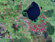
Map of Florida Cities and Roads

ADVERTISEMENT
City Maps for Neighboring States:
Alabama Georgia


Florida Cities:
Cities with populations over 10,000 include: Altamonte Springs, Apopka, Atlantic Beach, Bartow, Boca Raton, Boynton Beach, Bradenton, Callaway, Cape Coral, Clearwater, Cocoa, Cocoa Beach, Coral Gables, Coral Springs, Crestview, Daytona Beach, De Land, DeBary, Delray Beach, Deltona, Destin, Dunedin, Edgewater, Eustis, Fernandina Beach, Fort Lauderdale, Fort Myers, Fort Pierce, Fort Walton Beach, Gainesville, Gulfport, Haines City, Hialeah, Hollywood, Homestead, Jacksonville, Jacksonville Beach, Jupiter, Key West, Kissimmee, Lady Lake, Lake City, Lakeland, Largo, Leesburg, Lynn Haven, Melbourne, Miami, Miami Beach, Middleburg, Miramar, Naples, New Port Richey, New Smyrna Beach, Niceville, North Miami, North Port, Ocala, Oldsmar, Orange Park, Orlando, Ormond Beach, Palatka, Palm Bay, Palm Beach Gardens, Palm Valley, Palmetto, Panama City, Pembroke Pines, Pensacola, Pinellas Park, Plant City, Plantation, Pompano Beach, Port Orange, Port Saint Lucie, Punta Gorda, Rockledge, Saint Augustine, Saint Cloud, Saint Petersburg, Sanford, Sarasota, Satellite Beach, Sebastian, South Daytona, Stuart, Tallahassee, Tamarac, Tampa, Tarpon Springs, Titusville, Venice, Vero Beach, West Palm Beach, Winter Garden, Winter Haven and Winter Springs.
Florida Interstates:
North-South interstates include: Interstate 75, Interstate 95 and Interstate 275. East-West interstates include: Interstate 4 and Interstate 10.
Florida Routes:
US Highways and State Routes include: Route 1, Route 17, Route 19, Route 27, Route 29, Route 41, Route 90, Route 98, Route 129, Route 231, Route 301, Route 319, Route 331 and Route 441.
ADVERTISEMENT

