Home » US Maps » Washington » County Map
Washington County Map with County Seat Cities

ADVERTISEMENT
County Maps for Neighboring States:
Idaho Oregon


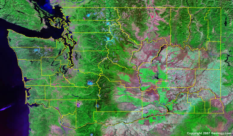
The map above is a Landsat satellite image of Washington with County boundaries superimposed. We have a more detailed satellite image of Washington without County boundaries.


ADVERTISEMENT
Washington Counties and County Seats |
|
|
Adams County - Ritzville Asotin County - Asotin Benton County - Prosser Chelan County - Wenatchee Clallam County - Port Angeles Clark County - Vancouver Columbia County - Dayton Cowlitz County - Kelso Douglas County - Waterville Ferry County - Republic Franklin County - Pasco Garfield County - Pomeroy Grant County - Ephrata Grays Harbor County - Montesano Island County - Coupeville Jefferson County - Port Townsend King County - Seattle Kitsap County - Port Orchard Kittitas County - Ellensburg Klickitat County - Goldendale |
Lewis County - Chehalis Lincoln County - Davenport Mason County - Shelton Okanogan County - Okanogan Pacific County - South Bend Pend Oreille County - Newport Pierce County - Tacoma San Juan County - Friday Harbor Skagit County - Mount Vernon Skamania County - Stevenson Snohomish County - Everett Spokane County - Spokane Stevens County - Colville Thurston County - Olympia Wahkiakum County - Cathlamet Walla Walla County - Walla Walla Whatcom County - Bellingham Whitman County - Colfax Yakima County - Yakima |
