Home » US Maps » Arizona » Lakes and Rivers
Arizona Lakes, Rivers and Water Resources
ADVERTISEMENT
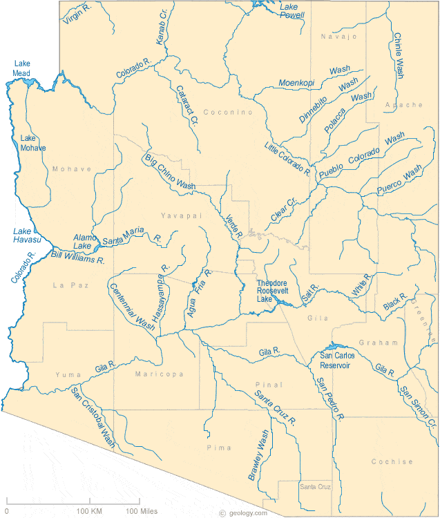
Arizona Rivers Shown on the Map: Agua Fria River, Big Chino Wash, Bill Williams River, Black River, Brawley Wash, Cataract Creek, Centennial Wash, Chinle Wash, Clear Creek, Colorado River, Dinnebito Wash, Gila River, Hassayampa River, Kanab Creek, Little Colorado River, Moenkopi Wash, Polacca Wash, Pueblo Colorado Wash, Puerco Wash, San Cristobal Wash, San Pedro River, San Simon Creek, Santa Cruz River, Santa Maria River, Virgin River and White River
Arizona Lakes Shown on the Map: Alamo Lake, Lake Havasu, Lake Mead, Lake Mohave, Lake Powell, San Carlos Reservoir and Theodore Roosevelt Lake.
| Arizona Stream and River Levels |
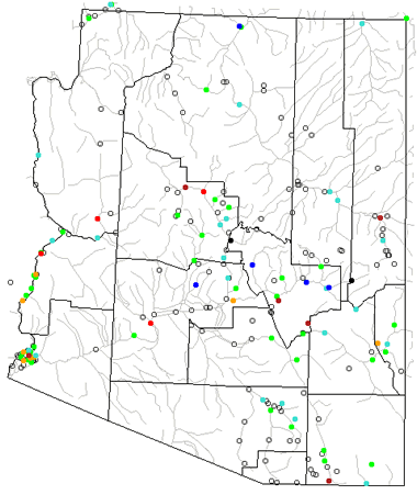 The United States Geological Survey has a number of stream gages located throughout Arizona. These estimate stream levels, discharges and record them over time. This data is published on the web and many stations allow users to plot custom graphs. Get updated Arizona river and stream levels from USGS here.
| Arizona Stream and River Level Alerts |
 The United States Geological Survey has a system that will send you an email message when flood levels are reached on any steam with USGS gaging equipment that you have selected. Sign up here to recieve Arizona stream and river level alerts.

| Arizona Drought Map |
 The United States Geological Survey publishes updated drought maps on their website. There you can view a map that shows where below normal 7-day average stream flow conditions were recently recorded. The maps are updated daily. Get a current Arizona drought map here.
| Arizona Water Publications |
 The United States Geological Survey has a number of publications related to water use and water resources in Arizona. Visit the Arizona Water Science Center here.
| Arizona Elevation Map |
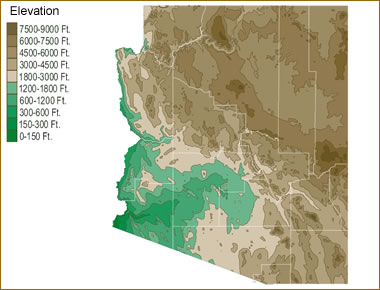 The topography of an area determines the direction of stream flow and often is a primary influence on the geographic distribution of precipitation. View a detailed Arizona elevation map.


Find Other Topics on Geology.com:

|

| ||

|

| ||

|

| ||

|

|