Home » US Maps » California » Lakes and Rivers
California Lakes, Rivers and Water Resources

ADVERTISEMENT
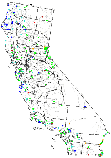
California Rivers Shown on the Map: Coachella Canal, Colorado River, Eel River, Feather River, Fraint-Kern Canal, Kern River, Kings River, Klamath River, Merced River, Mokelumne River, Owens River, Pit River, Russian River, Sacramento River, Salinas River, San Joaquin River, San Pedro Channel, Santa Barbara Channel, Stanislaus River and Trinity River.
California Lakes Shown on the Map: Buena Vista Lake, Clair Engle Lake, Clear Lake, Clear Lake Reservoir, Eagle Lake, Goose Lake, Honey Lake, Lake Almanor, Lake Havasu, Lake Oroville, Lake Tahoe, Mono Lake, Owens Lake, Salton Sea, San Luis Reservoir and Shasta Lake
| California Stream and River Levels |
 The United States Geological Survey has a number of stream gages located throughout California. These estimate stream levels, discharges and record them over time. This data is published on the web and many stations allow users to plot custom graphs. Get updated California river and stream levels from USGS here.
| California Stream and River Level Alerts |
 The United States Geological Survey has a system that will send you an email message when flood levels are reached on any steam with USGS gaging equipment that you have selected. Sign up here to recieve California stream and river level alerts.

| California Drought Map |
 The United States Geological Survey publishes updated drought maps on their website. There you can view a map that shows where below normal 7-day average stream flow conditions were recently recorded. The maps are updated daily. Get a current California drought map here.
| California Water Publications |
 The United States Geological Survey has a number of publications related to water use and water resources in California. Visit the California Water Science Center here.
| California Elevation Map |
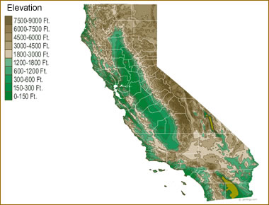 The topography of an area determines the direction of stream flow and often is a primary influence on the geographic distribution of precipitation. View a detailed California elevation map.


Find Other Topics on Geology.com:

|

| ||

|

| ||

|

| ||

|

|