Home » US Maps » Florida » Lakes and Rivers
Florida Lakes, Rivers and Water Resources

ADVERTISEMENT
Florida Rivers Shown on the Map: Apalachicola River, Caloosahatchee River, Chipola River, Escambia River, Hillsboro Canal, Kissimmee River, Miami Canal, Ochlockonee River, Peace River, Santa Fe River, St. Johns River, St. Marys River, Suwannee River and Withlacoochee River.
Florida Lakes Shown on the Map: Dead Lake, Lake Apopka, Lake George, Lake Harney, Lake Istokpoga, Lake Kissimmee, Lake Okeechobee and Lake Seminole.
| Florida Stream and River Levels |
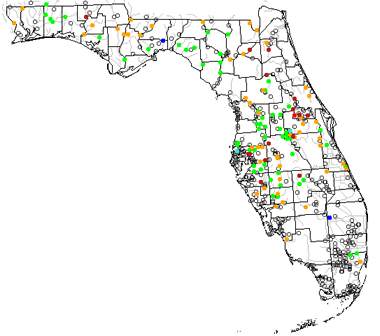 The United States Geological Survey has a number of stream gages located throughout Florida. These estimate stream levels, discharges and record them over time. This data is published on the web and many stations allow users to plot custom graphs. Get updated Florida river and stream levels from USGS here.
| Florida Stream and River Level Alerts |
 The United States Geological Survey has a system that will send you an email message when flood levels are reached on any steam with USGS gaging equipment that you have selected. Sign up here to recieve Florida stream and river level alerts.

| Florida Drought Map |
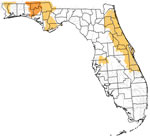 The United States Geological Survey publishes updated drought maps on their website. There you can view a map that shows where below normal 7-day average stream flow conditions were recently recorded. The maps are updated daily. Get a current Florida drought map here.
| Florida Water Publications |
 The United States Geological Survey has a number of publications related to water use and water resources in Florida. Visit the Caribbean-Florida Water Science Center here.
| Florida Elevation Map |
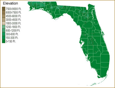 The topography of an area determines the direction of stream flow and often is a primary influence on the geographic distribution of precipitation. View a detailed Florida elevation map.


Find Other Topics on Geology.com:

|

| ||

|

| ||

|

| ||

|

|