Home » US Maps » Mississippi » Lakes and Rivers
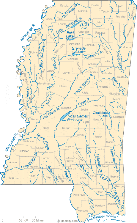
Mississippi Lakes, Rivers and Water Resources
ADVERTISEMENT
Mississippi Rivers Shown on the Map: Bayou Pierre, Big Black River, Big Sunflower River, Black River, Bogue Chitto, Chickasawhay River, Coldwater River, Deer Creek, Homochitto River, Leaf River, Little Tallahatchie River, Mississsippi River, Noxubee River, Pascagoula River, Pearl River, Tallahala Creek, Tombigbee River, Wolf River, Yalobusha River, Yazoo River and Yockanookany River.
Mississippi Lakes Shown on the Map: Enid Lake, Grenada Lake, Okatibbee Lake, Ross Barnett Reservoir and Sardis Lake.
| Mississippi Stream and River Levels |
 The United States Geological Survey has a number of stream gages located throughout Mississippi. These estimate stream levels, discharges and record them over time. This data is published on the web and many stations allow users to plot custom graphs. Get updated Mississippi river and stream levels from USGS here.
| Mississippi Stream and River Level Alerts |
 The United States Geological Survey has a system that will send you an email message when flood levels are reached on any stream with USGS gaging equipment that you have selected. Sign up here to receive Mississippi stream and river level alerts.

| Mississippi Drought Map |
 The United States Geological Survey publishes updated drought maps on their website. There you can view a map that shows where below normal 7-day average stream flow conditions were recently recorded. The maps are updated daily. Get a current Mississippi drought map here.
| Mississippi Water Publications |
 The United States Geological Survey has a number of publications related to water use and water resources in Mississippi. Visit the Lower Mississippi-Gulf Water Science Center here.
| Mississippi Elevation Map |
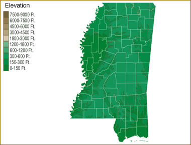 The topography of an area determines the direction of stream flow and often is a primary influence on the geographic distribution of precipitation. View a detailed Mississippi elevation map.


Find Other Topics on Geology.com:

|

| ||

|

| ||

|

| ||

|

|