Home » US Maps » New Mexico » Lakes and Rivers
New Mexico Lakes, Rivers and Water Resources

ADVERTISEMENT
New Mexico Rivers Shown on the Map: Canadian River, Cimarron River, Corrizo Creek, Gallinas River, Gila River, Mora River, Pecos River, Rio Chama, Rio Grande, Rio Hondo, Rio Penasco, Rio Puerco, Rio Salado, Rio San Jose, San Francisco River, San Juan River, Ute Creek and Vermejo River.
New Mexico Lakes Shown on the Map: Abiquiu Reservoir, Brantley Lake, Caballo Reservoir, Conchas Lake, Eagle Nest Lake, Elephant Butte Reservoir, Navajo Reservoir, Sumner Lake, Two Rivers Reservoir and Ute Reservoir.
| New Mexico Stream and River Levels |
 The United States Geological Survey has a number of stream gages located throughout New Mexico. These estimate stream levels, discharges and record them over time. This data is published on the web and many stations allow users to plot custom graphs. Get updated New Mexico river and stream levels from USGS here.
| New Mexico Stream and River Level Alerts |
 The United States Geological Survey has a system that will send you an email message when flood levels are reached on any steam with USGS gaging equipment that you have selected. Sign up here to recieve New Mexico stream and river level alerts.

| New Mexico Drought Map |
 The United States Geological Survey publishes updated drought maps on their website. There you can view a map that shows where below normal 7-day average stream flow conditions were recently recorded. The maps are updated daily. Get a current New Mexico drought map here.
| New Mexico Water Publications |
 The United States Geological Survey has a number of publications related to water use and water resources in New Mexico. Visit the New Mexico Water Science Center here.
| New Mexico Elevation Map |
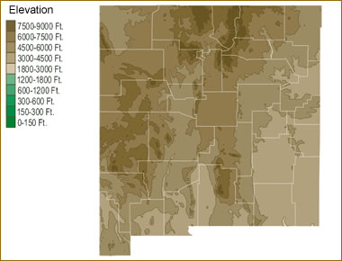 The topography of an area determines the direction of stream flow and often is a primary influence on the geographic distribution of precipitation. View a detailed New Mexico elevation map.


Find Other Topics on Geology.com:

|

| ||

|

| ||

|

| ||

|

|