Home » US Maps » New York » Lakes and Rivers
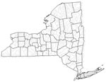
New York Lakes, Rivers and Water Resources

ADVERTISEMENT
New York Rivers Shown on the Map: Black River, Canisteo River, Cattaraugus Creek, Chemung River, Chenango River, Cohocton River, Delaware River, Erie Canal, Genesee River, Hudson River, Mohawk River, Raquette River, Saranac River, Schoharie Creek, Sesquehanna River, St. Lawrence River, St. Regis River, Tonawanda Creek and Wallkill River.
New York Lakes Shown on the Map: Allegheny Reservoir, Black Lake, Canandaigua lake, Cayuga Lake, Chatauqua Lake, Cranberry Lake, Great Sacandaga Lake, Keuka lake, Lake Champlain, Lake Erie, Lake George, Lake Ontario, Oneida Lake, Pepacton Reservoir, Seneca Lake, Skaneateles Lake and Stillwater Reservoir.
| New York Stream and River Levels |
 The United States Geological Survey has a number of stream gages located throughout New York. These estimate stream levels, discharges and record them over time. This data is published on the web and many stations allow users to plot custom graphs. Get updated New York river and stream levels from USGS here.
| New York Stream and River Level Alerts |
 The United States Geological Survey has a system that will send you an email message when flood levels are reached on any steam with USGS gaging equipment that you have selected. Sign up here to recieve New York stream and river level alerts.

| New York Drought Map |
 The United States Geological Survey publishes updated drought maps on their website. There you can view a map that shows where below normal 7-day average stream flow conditions were recently recorded. The maps are updated daily. Get a current New York drought map here.
| New York Water Publications |
 The United States Geological Survey has a number of publications related to water use and water resources in New York. Visit the New York Water Science Center here.
| New York Elevation Map |
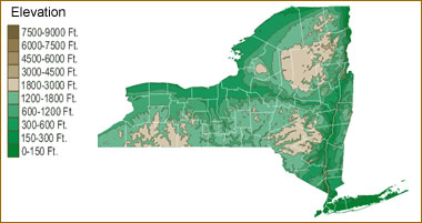 The topography of an area determines the direction of stream flow and often is a primary influence on the geographic distribution of precipitation. View a detailed New York elevation map.


Find Other Topics on Geology.com:

|

| ||

|

| ||

|

| ||

|

|