Home » US Maps » North Carolina » Lakes and Rivers
North Carolina Lakes, Rivers and Water Resources

ADVERTISEMENT
North Carolina Rivers Shown on the Map: Black River, Broad River, Cape Fear River, Catawba River, Chowan River, Deep River, Don River, French Broad River, Haw River, Lumber River, Neuse River, Northeast Cape Fear River, Pee Dee River, Roanoke River, Rocky River, South River, Tar River and Yadkin River.
North Carolina Lakes Shown on the Map: B. Everett Jordan Lake, Belews Lake, Chatuge Lake, Falls Lake, Fontana Lake, High Rock Lake, Hiwasee lake, John H. Kerr Reservoir, Lake Gaston, Lake James, Lake Mattamuskeet, Lake Norman, Long Bay, Onslow Bay and W. Kerr Scott Reservoir.
| North Carolina Stream and River Levels |
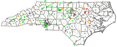 The United States Geological Survey has a number of stream gages located throughout North Carolina. These estimate stream levels, discharges and record them over time. This data is published on the web and many stations allow users to plot custom graphs. Get updated North Carolina river and stream levels from USGS here.
| North Carolina Stream and River Level Alerts |
 The United States Geological Survey has a system that will send you an email message when flood levels are reached on any steam with USGS gaging equipment that you have selected. Sign up here to recieve North Carolina stream and river level alerts.

| North Carolina Drought Map |
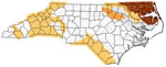 The United States Geological Survey publishes updated drought maps on their website. There you can view a map that shows where below normal 7-day average stream flow conditions were recently recorded. The maps are updated daily. Get a current North Carolina drought map here.
| North Carolina Water Publications |
 The United States Geological Survey has a number of publications related to water use and water resources in North Carolina. Visit the South Atlantic Water Science Center here.
| North Carolina Elevation Map |
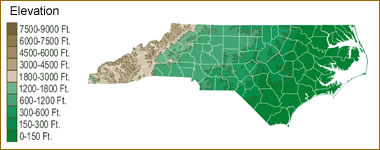 The topography of an area determines the direction of stream flow and often is a primary influence on the geographic distribution of precipitation. View a detailed North Carolina elevation map.


Find Other Topics on Geology.com:

|

| ||

|

| ||

|

| ||

|

|