Home » US Maps » Ohio » Lakes and Rivers
Ohio Lakes, Rivers and Water Resources

ADVERTISEMENT
Ohio Rivers Shown on the Map: Auglaize River, Big Darby Creek, Big Walnut Creek, Blanchard River, Cuyahoga River, Grand River, Great Miami River, Hoking River, Killbuck Creek, Licking River, Little Miami River,Mad River, Mahoning River, Maumee River, Muskingum River, Ohio River, Olentangy River, Paint Creek, Raccoon Creek, Sandusky River, Scioto River, St. Marys River and Tuscarawas River.
Ohio Lakes Shown on the Map: Grand Lake, Indian Lake, Mohawk Reservoir, Mosquito Creek Lake, Piedmont Lake, Pymatuning Reservoir, Senecaville Lake and William H. Harsha Lake.
| Ohio Stream and River Levels |
 The United States Geological Survey has a number of stream gages located throughout Ohio. These estimate stream levels, discharges and record them over time. This data is published on the web and many stations allow users to plot custom graphs. Get updated Ohio river and stream levels from USGS here.
| Ohio Stream and River Level Alerts |
 The United States Geological Survey has a system that will send you an email message when flood levels are reached on any steam with USGS gaging equipment that you have selected. Sign up here to recieve Ohio stream and river level alerts.

| Ohio Drought Map |
 The United States Geological Survey publishes updated drought maps on their website. There you can view a map that shows where below normal 7-day average stream flow conditions were recently recorded. The maps are updated daily. Get a current Ohio drought map here.
| Ohio Water Publications |
 The United States Geological Survey has a number of publications related to water use and water resources in Ohio. Visit the Ohio-Kentucky-Indiana Water Science Center here.
| Ohio Elevation Map |
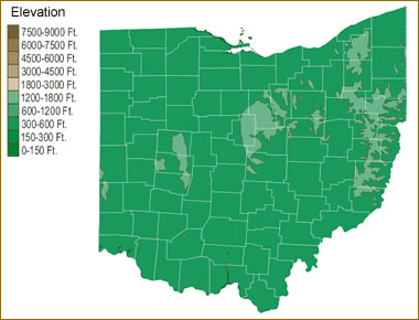 The topography of an area determines the direction of stream flow and often is a primary influence on the geographic distribution of precipitation. View a detailed Ohio elevation map.


Find Other Topics on Geology.com:

|

| ||

|

| ||

|

| ||

|

|