Home » US Maps » Oregon » Lakes and Rivers
Oregon Lakes, Rivers and Water Resources

ADVERTISEMENT
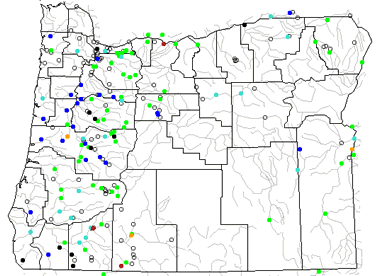
Oregon Rivers Shown on the Map: Bear Creek, Blitzen River, Burnt River, Butter Creek, Clackamas River, Columbia River, Coquille River, Crooked River, Deschutes River, Donner Und, Grande Ronde River, Illinois River, Imnaha River, John Day River, Klamath River, Lost River, Malheur River, McKenzie River, Nehalem River, North Umpqua River, Owyhee River, Powder River, Rogue River, Silver Creek, Silvies River, Siuslaw River, Snake River, South Santiam River, South Umpqua River, Sprague River, Umatilla River, Umpqua River, Wallowa River, Willamette River, Williamson River and Willow Creek.
Oregon Lakes Shown on the Map: Crater Lake, Fern Ridge Lake, Goose Lake, Harney lake, Lake Abert, Lake Billy Chinook, Lake Owyhee, Malheur Lake, Summer Lake, Upper Klamath Lake, Warner Lakes and Wickiup Reservoir.
| Oregon Stream and River Levels |
 The United States Geological Survey has a number of stream gages located throughout Oregon. These estimate stream levels, discharges and record them over time. This data is published on the web and many stations allow users to plot custom graphs. Get updated Oregon river and stream levels from USGS here.
| Oregon Stream and River Level Alerts |
 The United States Geological Survey has a system that will send you an email message when flood levels are reached on any steam with USGS gaging equipment that you have selected. Sign up here to recieve Oregon stream and river level alerts.
| Oregon Water Publications |
 The United States Geological Survey has a number of publications related to water use and water resources in Oregon. Visit the Oregon Water Science Center here.
| Oregon Elevation Map |
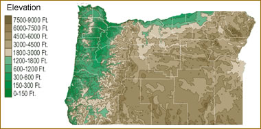 The topography of an area determines the direction of stream flow and often is a primary influence on the geographic distribution of precipitation. View a detailed Oregon elevation map.

| Oregon Waterfall: Multnomah Falls |
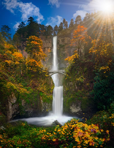 Multnomah Falls is the tallest waterfall in Oregon, with a total height of 620 feet. The source of the falls are underground springs in Larch Mountain, which feed Multnomah Creek. The creek flows to the Columbia River Gorge, where it spills over 2 tiers of steep basalt cliffs. The basalt at the top was more easily eroded, and this erosion is what caused the eventual formation of two tiers. The Benson Footbridge spans the lower falls at a height of 105 feet. Image copyright by iStockphoto / freebilly.
| Oregon Drought Map |
 The United States Geological Survey publishes updated drought maps on their website. There you can view a map that shows where below normal 7-day average stream flow conditions were recently recorded. The maps are updated daily. Get a current Oregon drought map here.


Find Other Topics on Geology.com:

|

| ||

|

| ||

|

| ||

|

|