Home » US Maps » Utah » Lakes and Rivers
Utah Lakes, Rivers and Water Resources

ADVERTISEMENT
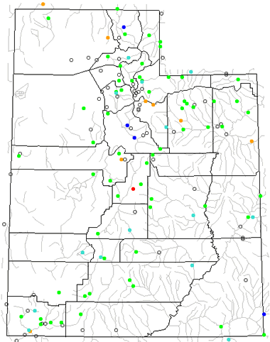
Utah Rivers Shown on the Map: Bear River, Colorado River, Dirty Devil River, Duchesne River, East Fork Sevier River, Escalante River, Fremont River, Green River, Lake Fork River, Muddy Creek, Otter Creek, Paria River, Price River, Provo River, San Juan River, San Pitch River, San Rafael River, Sevier River, Uinta River, Virgin River, Weber River, White River and Willow Creek.
Utah Lakes Shown on the Map: Bear lake, Flaming Gorge Reservoir, Great Salt Lake, Lake Powell, Piute Reservoir, Sevier Lake, Starvation Reservoir, Strawberry Reservoir and Utah Lake.
| Utah Stream and River Levels |
 The United States Geological Survey has a number of stream gages located throughout Utah. These estimate stream levels, discharges and record them over time. This data is published on the web and many stations allow users to plot custom graphs. Get updated Utah river and stream levels from USGS here.
| Utah Stream and River Level Alerts |
 The United States Geological Survey has a system that will send you an email message when flood levels are reached on any steam with USGS gaging equipment that you have selected. Sign up here to recieve Utah stream and river level alerts.

| Utah Drought Map |
 The United States Geological Survey publishes updated drought maps on their website. There you can view a map that shows where below normal 7-day average stream flow conditions were recently recorded. The maps are updated daily. Get a current Utah drought map here.
| Utah Water Publications |
 The United States Geological Survey has a number of publications related to water use and water resources in Utah. Visit the Utah Water Science Center here.
| Utah Elevation Map |
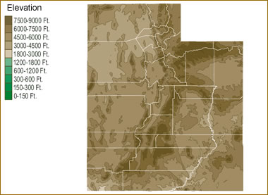 The topography of an area determines the direction of stream flow and often is a primary influence on the geographic distribution of precipitation. View a detailed Utah elevation map.


Find Other Topics on Geology.com:

|

| ||

|

| ||

|

| ||

|

|