Home » US Maps » Washington » Lakes and Rivers
Washington Lakes, Rivers and Water Resources

ADVERTISEMENT
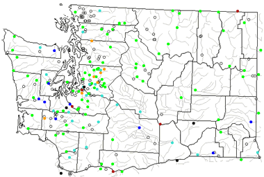
Washington Rivers Shown on the Map: Chehalis River, Columbia River, Cowlitz River, Entiat River, Hangman Creek, Klicktat River, Lewis River, Lower Crab Creek, Methow River, Naches River, Nisqually River, Nooksack River, Okanongan River, Palouse River, Pend Oreille River, Puyallup River, Quinault River, Rock Creek, Sanpoil River, Skagit River, Skykomish River, Snake River, Spokane River, Toppenish Creek, Touchet River, Tucannon River, Union Flat Creek, Wenatchee River and Yakima River.
Washington Lakes Shown on the Map: Banks Lake, Franklin D. Roosevelt Lake, Lake Chelan, Lake Crescent, Lake Sacajawea, Lake Wallula, Lake Washington, Moses Lake, Ozette Lake, Potholes Reservoir and Ross Lake.
| Washington Stream and River Levels |
 The United States Geological Survey has a number of stream gages located throughout Washington. These estimate stream levels, discharges and record them over time. This data is published on the web and many stations allow users to plot custom graphs. Get updated Washington river and stream levels from USGS here.
| Washington Stream and River Level Alerts |
 The United States Geological Survey has a system that will send you an email message when flood levels are reached on any steam with USGS gaging equipment that you have selected. Sign up here to recieve Washington stream and river level alerts.

| Washington Drought Map |
 The United States Geological Survey publishes updated drought maps on their website. There you can view a map that shows where below normal 7-day average stream flow conditions were recently recorded. The maps are updated daily. Get a current Washington drought map here.
| Washington Water Publications |
 The United States Geological Survey has a number of publications related to water use and water resources in Washington. Visit the Washington Water Science Center here.
| Washington Elevation Map |
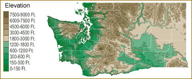 The topography of an area determines the direction of stream flow and often is a primary influence on the geographic distribution of precipitation. View a detailed Washington elevation map.


Find Other Topics on Geology.com:

|

| ||

|

| ||

|

| ||

|

|