Makes a great gift!
New Jersey DeLorme Atlas
Complete New Jersey Road Map and
Topographic Map Coverage
- Topo Maps with Back Roads
- 67 Pages of Maps
- 21 Pages of Attractions, Information and Places to Visit
- Scale: 1:77,000 (1" = 1.2 miles)
Some suggested ways to use this atlas:
|
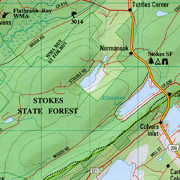
A Sample Map From This Book
Some of the Map Symbols
| Attractions | |
| Paddling | |
| Campgrounds | |
| Fishing | |
| Hunting | |
| Trails | |
| Recreation Areas | |
| Scenic Drives | |
| Historic Sites | |
| Ski Areas | |
| Golf Courses | |
| Wildlife Viewing | |
There are 21 pages of reference information that include: New Jersey's recreation areas, historic sites, attractions, casinos, golf courses, unique natural features, paddling, hiking, fishing, hunting and camping. Also included are street maps for Atlantic City, Newark and vicinity, Camden and Trenton. The extra features and details in this up-to-date map collection will make your trip-planning easy!