Home » Rocks » Oil Shale » Estonia and Sweden
Estonia and Sweden Oil-Shale Deposits
Reprint of: United States Geological Survey Scientific Investigations Report 2005-5294
By John R. Dyni
| Estonia and Sweden Oil Shale |
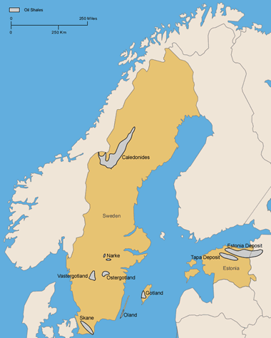
Map of kukersite deposits in northern Estonia and Russia (locations after Kattai and Lokk, 1998; and Bauert, 1994). Also, areas of Alum Shale in Sweden (locations after Andersson and others, 1985). Click to enlarge map.
Estonia
The Ordovician kukersite deposits of Estonia have been known since the 1700s. However, active exploration only began as a result of fuel shortages brought on by World War I. Full-scale mining began in 1918. Oil-shale production in that year was 17,000 tons by open-pit mining, and by 1940, the annual production reached 1.7 million tons. However, it was not until after World War II, during the Soviet era, that production climbed dramatically, peaking in 1980 when 31.4 million tons of oil shale were mined from eleven open-pit and underground mines.
The annual production of oil shale decreased after 1980 to about 14 million tons in 1994-95 (Katti and Lokk, 1998; Reinsalu, 1998a) then began to increase again. In 1997, 22 million tons of oil shale were produced from six room-and-pillar underground mines and three open-pit mines (Opik, 1998). Of this amount, 81 percent was used to fuel electric power plants, 16 percent was processed into petrochemicals, and the remainder was used to manufacture cement as well as other minor products. State subsidies for oil-shale companies in 1997 amounted to 132.4 million Estonian kroons (9.7 million U.S. dollars) (Reinsalu, 1998a).
The kukersite deposits occupy more than 50,000 km2 in northern Estonia and extend eastward into Russia toward St. Petersburg where it is known as the Leningrad deposit. In Estonia a somewhat younger deposit of kukersite, the Tapa deposit, overlies the Estonia deposit.
As many as 50 beds of kukersite and kerogen-rich limestone alternating with biomicritic limestone are in the Kõrgekallas and Viivikonna Formations of Middle Ordovician age. These beds form a 20- to 30-m-thick sequence in the middle of the Estonia field. Individual kukersite beds are commonly 10-40 cm thick and reach as much as 2.4 m. The organic content of the richest kukersite beds reaches 40-45 weight percent (Bauert, 1994).
Rock-Eval analyses of the richest-grade kukersite in Estonia show oil yields as high as 300 to 470 mg/g of shale, which is equivalent to about 320 to 500 l/t. The calorific value in seven open-pit mines ranges from 2,440 to 3,020 kcal/kg (Reinsalu, 1998a, his table 5). Most of the organic matter is derived from the fossil green alga, Gloeocapsomorpha prisca, which has affinities to the modern cyanobacterium, Entophysalis major, an extant species that forms algal mats in intertidal to very shallow subtidal waters (Bauert, 1994).
Matrix minerals in Estonian kukersite and interbedded limestones includes dominantly low-Mg calcite (>50 percent), dolomite (<10-15 percent), and siliciclastic minerals including quartz, feldspars, illite, chlorite, and pyrite (<10-15 percent). The kukersite beds and associated limestones are evidently not enriched in heavy metals, unlike the Lower Ordovician Dictyonema Shale of northern Estonia and Sweden (Bauert, 1994; Andersson and others, 1985).
Bauert (1994, p. 418-420) suggested that the kukersite and limestone sequence was deposited in a series of east-west "stacked belts" in a shallow subtidal marine basin adjacent to a shallow coastal area on the north side of the Baltic Sea near Finland. The abundance of marine macrofossils and low pyrite content indicate an oxygenated-water setting with negligible bottom currents as evidenced by widespread lateral continuity of uniformly thin beds of kukersite.
Kattai and Lokk (1998, p. 109) estimated the proved and probable reserves of kukersite to be 5.94 billion tons. A good review of the criteria for estimating Estonia's resources of kukersite oil shale was made by Reinsalu (1998b). In addition to thickness of overburden and thickness and grade of the oil shale, Reinsalu defined a given bed of kukersite as constituting a reserve, if the cost of mining and delivering the oil shale to the consumer was less than the cost of the delivery of the equivalent amount of coal having an energy value of 7,000 kcal/kg. He defined a bed of kukersite as a resource as one having an energy rating exceeding 25 GJ/m2 of bed area. On this basis, the total resources of Estonian kukersite in beds A through F (fig. 8) are estimated to be 6.3 billion tons, which includes 2 billion tons of "active" reserves (defined as oil shale "worth mining"). The Tapa deposit is not included in these estimates.
The number of exploratory drill holes in the Estonia field exceeds 10,000. The Estonia kukersite has been relatively thoroughly explored, whereas the Tapa deposit is currently in the prospecting stage.
-Dictyonema Shale
Another older oil-shale deposit, the marine Dictyonema Shale of Early Ordovician age, underlies most of northern Estonia. Until recently, little has been published about this unit because it was covertly mined for uranium during the Soviet era. The unit ranges from less than 0.5 to more than 5 m in thickness. A total of 22.5 tons of elemental uranium was produced from 271,575 tons of Dictyonema Shale from an underground mine near Sillamäe. The uranium (U3O8) was extracted from the ore in a processing plant at Sillamäe (Lippmaa and Maramäe, 1999, 2000, 2001).
The future of oil-shale mining in Estonia faces a number of problems including competition from natural gas, petroleum, and coal. The present open-pit mines in the kukersite deposits will eventually need to be converted to more expensive underground operations as the deeper oil shale is mined. Serious air and ground-water pollution have resulted from burning oil shale and leaching of trace metals and organic compounds from spoil piles left from many years of mining and processing the oil shales. Reclamation of mined-out areas and their associated piles of spent shale, and studies to ameliorate the environmental degradation of the mined lands by the oil-shale industry are underway. The geology, mining, and reclamation of the Estonia kukersite deposit were reviewed in detail by Kattai and others (2000).
| Oil Shale - Country Menu |
Sweden
The Alum Shale is a unit of black organic-rich marinite about 20-60 m thick that was deposited in a shallow marine-shelf environment on the tectonically stable Baltoscandian Platform in Cambrian to earliest Ordovician time in Sweden and adjacent areas. The Alum Shale is present in outliers, partly bounded by local faults, on Precambrian rocks in southern Sweden as well as in the tectonically disturbed Caledonides of western Sweden and Norway, where it reaches thicknesses of 200 m or more in repeated sequences owing to multiple thrust faults (fig. 14).
Black shales, equivalent in part to the Alum Shale, are present on the islands of Öland and Götland, underlie parts of the Baltic Sea, and crop out along the north shore of Estonia where they form the Dictyonema Shale of Early Ordovician (Tremadocian) age (Andersson and others, 1985, their figs. 3 and 4). The Alum Shale represents slow deposition in shallow, near-anoxic waters that were little disturbed by wave- and bottom-current action.
The Cambrian and Lower Ordovician Alum Shale of Sweden has been known for more than 350 years. It was a source of potassium aluminum sulfate that was used in the leather tanning industry, for fixing colors in textiles, and as a pharmaceutical astringent. Mining the shales for alum began in 1637 in Skåne. The Alum Shale was also recognized as a source of fossil energy and, toward the end of the 1800s, attempts were made to extract and refine hydrocarbons (Andersson and others, 1985, p. 8-9).
Before and during World War II, Alum Shale was retorted for its oil, but production ceased in 1966 owing to the availability of cheaper supplies of crude petroleum. During this period, about 50 million tons of shale was mined at Kinnekulle in Västergötland and at Närke.
The Alum Shale is remarkable for its high content of metals including uranium, vanadium, nickel, and molybdenum. Small amounts of vanadium were produced during World War II. A pilot plant built at Kvarntorp produced more than 62 tons of uranium between 1950 and 1961. Later, higher-grade ore was identified at Ranstad in Västergötland, where an open-pit mine and mill were established. About 50 tons of uranium per year were produced between 1965 and 1969. During the 1980s, production of uranium from high-grade deposits elsewhere in the world caused a drop in the world price of uranium to levels too low to profitably operate the Ranstad plant, and it closed in 1989 (Bergh, 1994).
Alum Shale was also burned with limestone to manufacture "breeze blocks," a lightweight porous building block that was used widely in the Swedish construction industry. Production stopped when it was realized that the blocks were radioactive and emitted unacceptably large amounts of radon. Nevertheless, the Alum Shale remains an important potential resource of fossil and nuclear energy, sulfur, fertilizer, metal alloy elements, and aluminum products for the future. The fossil energy resources of the Alum Shale in Sweden are summarized in table 6.
The organic content of Alum Shale ranges from a few percent to more than 20 percent, being highest in the upper part of the shale sequence. Oil yields, however, are not in proportion to the organic content from one area to another because of variations in the geothermal history of the areas underlain by the formation. For example, at Skåne and Jämtland in west-central Sweden, the Alum Shale is overmature and oil yields are nil, although the organic content of the shale is 11-12 percent. In areas less affected by geothermal alteration, oil yields range from 2 to 6 percent by Fischer assay. Hydroretorting can increase the Fischer assay yields by as much as 300 to 400 percent (Andersson and others, 1985, their fig. 24).
The uranium resources of the Alum Shale of Sweden, although low grade, are enormous. In the Ranstad area of Västergötland, for example, the uranium content of a 3.6-m-thick zone in the upper part of the formation reaches 306 ppm, and concentrations reach 2,000 to 5,000 ppm in small black coal-like lenses of hydrocarbon (kolm) that are scattered through the zone.
The Alum Shale in the Ranstad area underlies about 490 km2, of which the upper member, 8 to 9 m thick, contains an estimated 1.7 million tons of uranium metal (Andersson and others, 1985, their table 4).
| More Oil |
 |
Horizontal Drilling |
 |
Oil and Gas Rights |
 |
Shale Gas Resources |
 |
Gifts That Rock |
 |
What is LNG? |
 |
The Doorway to Hell |
 |
Natural Gas Investing |
 |
Helium |

Find Other Topics on Geology.com:

|

| ||

|

| ||

|

| ||

|

|