Home » World Maps » Arctic Ocean
Arctic Ocean Map and Bathymetric Chart

This map illustrates the Arctic Ocean, the names of the "seas" that on the northern borders of the contients, and is a political map of bordering countries. It also shows the Arctic Circle and areas that are sometimes covered with sea ice.
ADVERTISEMENT
Within the last several years, a significant amount of interest has developed in the Arctic Ocean and its seafloor features. Three factors are important in driving this new level of interest in the Arctic.
First, an enormous amount of oil, natural gas and other resources are thought to be held within the Arctic Ocean's floor. The United States Geological Survey estimates that up to 25% of the world's remaining oil and natural gas resource might be held within the Arctic Region.
Second, global warming is starting to reduce the extent and thickness of the Arctic's sea ice. If the current trend continues, the Northwest Passage (a route from the Atlantic to the Pacific through the islands of the Canadian archipelago) might be regularly traversed during the summer. Some forecasts indicate that the Arctic could be ice-free in summer by midway through the current century. Ships taking the Northwest Passage instead of other routes could cut their travel time by several days.
Third, the 1982 United Nations Convention on the Law of the Sea allows nations to extend their coastal economic zone beyond 350 nautical miles - if they can acquire scientific data that demonstrates that additional areas are a natural extension of their continent. Many nations are fielding scientific missions in hopes of extending their Arctic opportunities. For more information see: Who Owns the Arctic?
Shown below is the International Bathymetric Chart of the Arctic Ocean which was produced by a team of investigators from Canada, Denmark, Germany, Iceland, Norway, Russia, Sweden, and the United States. It can be considered a "physical map of the Arctic Ocean" as it shows the bathymetry, ridges and basins that are part of this important area.
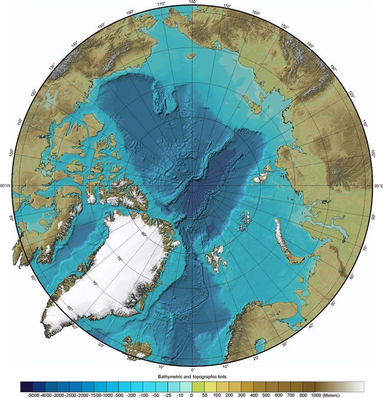
The International Bathymetric Chart of the Arctic Ocean was produced by investigators representing the Intergovernmental Oceanographic Commission (IOC), the International Arctic Science Committee (IASC), the International Hydrographic Organization (IHO), the US Office of Naval Research (ONR), and the US National Geophysical Data Center (NGDC).

ADVERTISEMENT