Home » World Maps » South America » Physical Map
South America Physical Map
| Click on a country to go to a political map of that country. |
| Google Earth: High Resolution Satellite Images - Worldwide Coverage - Free! |
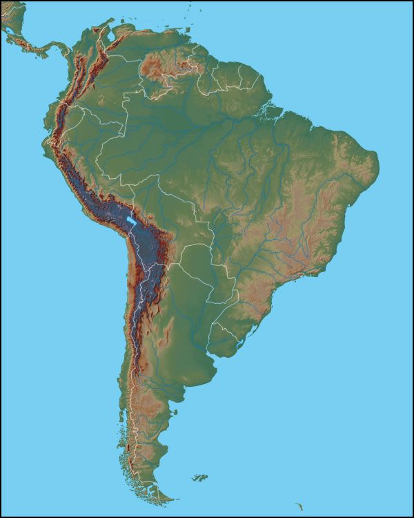
Physical Map of South America
The map above reveals the physical landscape of the South American Continent. Important mountainous areas are the Brazilian Highlands, the Guiana Highlands, the Serra Dois Irmaos and the Serra Grande. The most mountainous area is on the western side of the continent. Topography there is dominated by the Andes Mountains. Other important ranges include the Cordillera de Merida, the Coast Range, the Cordillera Oriental and the Cordillera Occidental.
Major South American lakes include Lake Maracaibo in Venezuela and Lake Titicaca in Peru.

| Click on a country to go to a more detailed map of that country. |
Copyright information: The images on this page were composed by Brad Cole and Angela King and are copyright by Geology.com. If you would like to share them with others please link to this page. They are not available for use beyond our websites. The maps were produced using data licensed from and copyright by Map Resources.
| More Geology Topics |
 |
General Geology |
 |
Plate Tectonics |
 |
Rocks |
 |
Oil and Gas |
 |
Earthquakes |
 |
Astronomy |
 |
Fossils |
 |
Geologic Hazards |

Find Other Topics on Geology.com:

|

| ||

|

| ||
|

| ||

|

|