 Makes a great gift!
Kentucky DeLorme Atlas
Complete Kentucky Road Map and
Topographic Map Coverage
- Large 11" x 15.5" Pages
- Topo Maps with Back Roads
- 67 Pages of Maps
- 21 Pages of Attractions, Information and Places to Visit
- Scale: 1:150,000 (1" = 2.4 miles)
Some suggested ways to use this atlas:
- Map a drive on the Horse Country Tour
- Plan your weekend hike at Daniel Boone National Forest
- Explore Louisville's museums, sights and culture!
- Plan your tour of Kentucky's distilleries
|
Ships right away by Priority Mail
A Sample Map From This Book
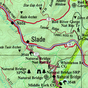
Some of the Map Symbols
 |
Attractions |
 |
Biking |
 |
Campgrounds |
 |
Covered Bridges |
 |
Fishing |
 |
Scenic Drives |
 |
State Lands |
 |
Wildlife Viewing |
 |
Historic Sites |
 |
Paddling |
 |
Hiking |
 |
Hunting |
The atlas has 21 pages of reference information on Kentucky's fishing, hunting, campgrounds, wildlife, scenic drives, covered bridges, paddling, biking, hiking, unique natural features, distilleries, historic sites and public lands. The extra features and detail of this up-to-date map collection will make your trip-planning easy!