Makes a great gift!
Louisiana DeLorme Atlas
Complete Louisiana Road Map and
Topographic Map Coverage
- Topo Maps with Back Roads
- 49 Pages of Maps
- 15 Pages of Attractions, Information and Places to Visit
- Scale: 1:182,000 (1" = 2.9 miles)
The DeLorme Atlas and Gazetteer can help you to:
|
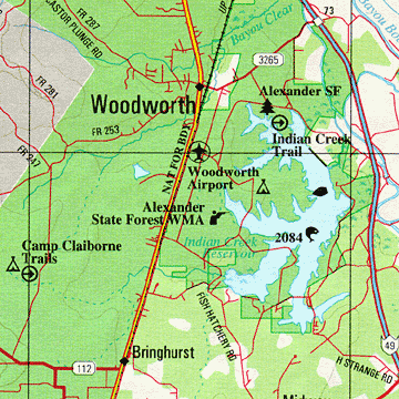
A Sample Map From This Book
Some of the Map Symbols
| Attractions | |
| Gardens | |
| Campgrounds | |
| Saltwater Fishing | |
| Freshwater Fishing | |
| Scenic Drives | |
| Recreation Areas | |
| Trails | |
| Museums/Historic Sites | |
| Canoeing | |
| Golf Courses | |
| Hunting | |
The back cover of this atlas has a large map of Louisiana with an overlying grid. Each cell of the grid contains the page number for a detailed map of that area. In addition, the atlas has an index of the state's place names and map features for easy look-up. The detailed maps in this atlas show both physical and man-made features. These include: rivers, lakes, reservoirs, creeks, bayous, bays, islands, forests, place names, airports, railroads, oil and gas fields, roads, highways, interstates, wildlife management areas and parks. State-wide topographic information is shown by contour lines with intervals of 60 or 120 feet, depending on the terrain. You will be impressed with the details and extras that the DeLorme Atlas and Gazetteer has to offer!