 Makes a great gift!
Ohio DeLorme Atlas
Complete Ohio Road Map and
Topographic Map Coverage
- Large 11" x 15.5" Pages
- Topo Maps with Back Roads
- 62 Pages of Maps
- 18 Pages of Attractions, Information and Places to Visit
- Scale: 1:160,000 (1" = 2.5 miles)
Some suggested ways to use this atlas:
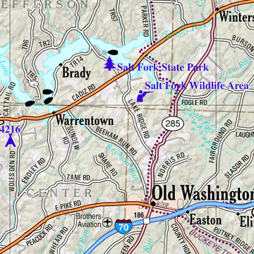
- Review recreation possibilities near Salt Fork State Park
- Find camping near Findley State Park
- Map bicycle routes along the Little Miami Scenic River
- Find museums and science centers in Cincinnati
|
Ships right away by Priority Mail
A Sample Map From This Book
Some of the Map Symbols
 |
Campgrounds |
 |
Family Outings |
 |
Fishing |
 |
Boat Launch Site |
 |
Hunting |
 |
Outdoor Adventures |
 |
Recreation Areas |
 |
Unique Natural Features |
 |
Lighthouse |
 |
Golf Course |
 |
Windmill |
 |
Information Center |
This atlas has 18 additional pages of reference information on the state's recreation and attractions. These pages include information on Ohio's fishing, hunting, hiking, biking, paddling, campgrounds, family outings and unique natural features. There are so many details and extras you will not be disappointed with the DeLorme Atlas and Gazetteer!