Wall Map of Antarctica and the Southern Ocean
Laminated Political, Physical, Bathymetric Map of Antarctica and the Southern Ocean
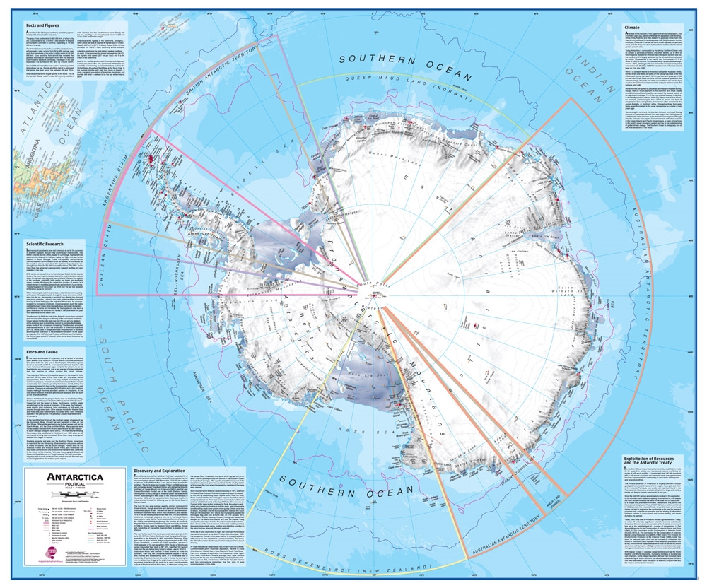
Map Dimensions: 47 inches wide x 39 inches tall. Click here for more detail.
Approximate Scale: 1 : 7,000,000
The South Polar Lands and Oceans in Great Detail
This is the largest and most detailed map of Antarctica and the Southern Ocean that we have seen at a price of under $100. It is perfect for students, schools, researchers and anyone who needs a high-quality map of Antarctica - and this one is laminated to make it durable. It is an extremely detailed presentation of political, physical and bathymetric information.ADVERTISEMENT
If you have a special interest in the South Polar area, this is a great map to display on your wall. Or, you can store it safely in its sturdy tube - to keep it quickly available for reference.
This document is much more than a map. It features special text boxes in each corner of the map. These summarize the region’s climate, flora, fauna, discovery, exploration, and potential resource exploitation.
Political Map Features
The Antarctic Region is defined as all of the land and ice shelves that exist south of 60 degrees south latitude. Antarctica is not divided into "countries" like other parts of the world. Instead, the continent has been tentatively divided into territorial "claims" by seven nations: Norway, Australia, France, New Zealand, Chile, Argentina, and the United Kingdom.Most of these claims are sectors of the region. These begin at 60 degrees south latitude and extend to the South Pole along lines of longitude. Twenty-eight other countries have not made formal claims on portions of the Antarctic Territory. These countries, including Russia and the United States, have reserved their right to make claims, and most of these 28 countries do not recognize claims already made by other nations.
The map shows the location of numerous base camps, each attributed to the country that utilizes them. Numerous ice stations, weather stations and aircraft landing areas are also shown. Historical annotations include major expedition routes taken by Scott (1902-1903 and 1911-1912), Shackleton (1908-1909), and Amundsen (1911-1912).
"Land" and Sea Ice Features and Extents
Most of the "land" area of Antarctica is covered by snow and ice, and much of what appears to be "land" on the map is actually glacial ice slowly flowing across bedrock that is above sea level. A significant portion is "anchor ice" that is resting on a bedrock surface that is below sea level. These areas are shown on the map in white with tints of brown that show physical relief.Much of Antarctica is surrounded by the Antarctic Ice Pack. The ice pack (also known as "sea ice") is a frozen sea surface or broken pieces of ice that often have a cover of snow. The size of the ice pack expands and melts in an annual cycle as the seasons of the South Polar area change. The ice pack is of minimal extent near the end of the Antarctic summer and of maximum extent near the end of the Antarctic winter. The typical winter (maximum) ice extent is shown as a black line on the surface of the Southern Ocean and other water bodies. The typical summer extent (minimum) ice extent is shown as a red line. The generalized shapes of the important ice shelves are shown with a variable gray tint. These include the Ronne, Ross, Larsen and numerous other ice shelves.
Topographic and Bathymetric Map Features
The mountains, mountain ranges and elevated glacial surfaces of Antarctica are shown in shaded relief. Unannotated contour lines provide a perspective of local relief. Significant peaks are shown with triangular symbols with elevation annotations. Generalized bathymetry of the Southern Ocean and the numerous seas surrounding Antarctica are shown in shades of blue.This is a great map for display, study, research or reference.