Political Map of Africa - Laminated Wall Map
Laminated Political Wall Map of Africa
Map Dimensions: 47 inches tall x 39 inches wide. Click here for more detail.
A Spectacular Map of Africa
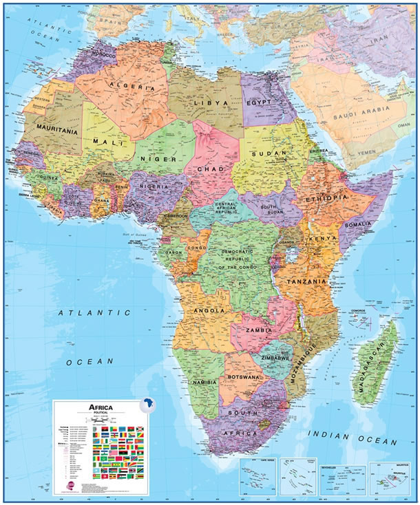
This is a great map of Africa for students, schools, homes or offices. It shows the countries of Africa in great detail along with their boundaries, important cities, major transportation features, lakes, rivers, mountains, deserts and other cultural and physical features. It is large, colorful, beautiful, and its lamination makes a durable map. You can write on it with dry-erase markers and wipe them off when finished. Post-It notes make great markers that cleanly remove when you are finished.
ADVERTISEMENT
This map will be an attractive and functional addition to your room, or keep it rolled in its tube for occasional use. It has wonderful blue oceans, brightly colored countries, and excellent geographic detail. Use it anywhere that a map is needed for education, display, or decor. Lamination makes it easy to hang and protects it during handling.
Geography of Continents, Countries and Cities
The Africa Political Map shows the major cities and capital cities of Africa. They are marked with symbols that indicate their relative population. Major highways and important roads are marked on the map as red lines. Country boundaries are shown as magenta lines. Red symbols are used for important airports. Mount Kilimanjaro, the highest mountain in Africa, is marked along with numerous other significant peaks. Major mountain ranges are shown in shaded relief. The map represents the continent of Africa at a 1:8,000,000 equatorial scale using a Miller Oblated projection.
Plan or share your trip to Africa on this map!
Use pins or removable tape to attach photos, tickets, notes, signs, flags and more.
Ocean and Freshwater Detail
Ocean depths are shown with blue color shading. This allows you to easily see the areas along the East African Coast that are shallow enough for oil and gas drilling; the areas off the southwestern coast that are shallow enough for diamond dredging; and, areas where other subsea mineral exploration might occur. On the continent you can see Africa's numerous major lakes and rivers. You can trace the Nile River from its delta, over one thousand miles inland, and see it branch into the Blue and White Niles. You can follow the East Africa Rift Valley from the Red Sea, through Ethiopia, Kenya, Uganda, Tanzania, and into Mozambique - all along the way, important freshwater lakes are marking its route. Offshore, you can see many tiny islands that you probably didn't know existed. Inset maps are provided for details of the Cape Verde, Azores, Seychelles, and Mauritius Islands. Offshore you can see the Comoros, Sao Tome & Principe, and Canary Islands. Ocean depths are marked at significant locations. Latitude and longitude lines are clearly marked.
African Countries Shown on this Map
A total of fifty-five African countries are shown on the map. They include: Algeria, Angola, Benin, Botswana, Burkina Faso, Burundi, Cameroon, Cape Verde, Central African Republic, Chad, Comoros Islands, Congo, Democratic Republic of the Congo, Djibouti, Egypt, Equatorial Guinea, Guinea-Bissau, Ivory Coast, Kenya, Lesotho, Liberia, Libya, Madagascar, Malawi, Mali, Mauritania, Mauritius, Morocco, Mozambique, Namibia, Niger, Nigeria, Rwanda, Sao Tome & Principe, Senegal, Seychelles, Sierra Leone, Somalia, South Africa, South Sudan, Sudan, Swaziland, Tanzania, Togo, Tunisia, Uganda, Western Sahara, Zambia, and Zimbabwe.
A Great Map for Home Learning
One of the most valuable uses of a map like this is in the home. When you learn about an important event in Africa while watching the news or reading a news website, you can find its location on the map. This will enrich your understanding of the event and your knowledge of African geography. This is a great map for those who are home schooling.
How We Ship This Map to You
This is a large map and we want you to receive it in perfect condition. To do that we neatly roll it - face-inwards - and insert it into a sturdy map tube. We ship all of our laminated maps through the United States Postal Service using Ground Advantage. Your map will ship no later than the next business day after your order is placed. We ship Ground Advantage to all customer addresses in the contiguous United States, Hawaii, Alaska, APO, FPO, and all official United States Territories. (Sorry, we are unable to ship any purchases to countries outside of the United States.) If you order other items at the same time, your map will be shipped in a separate tube.
