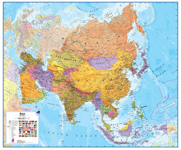
Political Map of Asia - Laminated Wall Map

Laminated Political Wall Map of Asia
Map Dimensions: 39 inches tall x 47 inches wide. Click here for more detail.
A Spectacular Map of Asia
This is a great map of Asia for students, schools, homes or offices. It shows the countries of Asia in great detail along with their boundaries, important cities, major transportation features, lakes, rivers, mountains, deserts, and other cultural and physical features. It is large, colorful, and beautiful.ADVERTISEMENT
The lamination makes it a durable map that will last for many years. You can write on it with dry-erase markers and wipe them off when finished. Post-It notes make great markers that cleanly remove when you are done with your project.
This map will be an attractive and functional addition to your room, or keep it rolled in its sturdy map tube for occasional use. It has wonderful blue oceans, brightly colored countries, and accurate geographic detail. Use it anywhere that a map is needed for education, display, or decor. Lamination makes it easy to hang and display.
Plan or share your trip to Asia on this map!
Use pins or removable tape to attach photos, tickets, notes, signs, flags and more.
Use pins or removable tape to attach photos, tickets, notes, signs, flags and more.
Geography of Continents, Countries and Cities
This map depicts the countries of Asia in bright colors with red borders. The capital city and major cities of each country are shown with different size symbols that indicate their relative population. Thousands of cities are shown. Major highways and important roads are marked as red lines.Major mountain ranges are shown in shaded relief and labeled by name. Asia is home to the Himalaya Mountain Range, the range that contains many of the world's tallest peaks. Many important inland lakes are in Asia, including Lake Baikal in Siberia. It is the largest lake in the world on the basis of volume.
The map represents the continent of Asia at a 1:11,000,000 equatorial scale using a Lambert Azimuthal Equal Area projection.
Ocean and Freshwater Detail
Unlike many other maps of Asia, this one shows large portions of the Arctic Ocean where Russia claims exclusive economic rights to important energy resources. It also shows the waters of the Northern Sea Route that connects the Atlantic and Pacific Oceans through icy Arctic waters.The oceans and major seas are shown in a gradient of blue colors that represent different water depths. This allows you to see ocean trenches, mid-ocean ridges, and continental shelf areas at a glance. The South China Sea and Sea of Japan are in these shallow-water areas, where the sovereignty of tiny islands is hotly contested because of the seafloor resources that surround them.
