Political Map of Europe - Laminated Wall Map

Laminated Political Wall Map of Europe
Map Dimensions: 39 inches tall x 55 inches wide. Click here for more detail.
A Spectacular Map of Europe
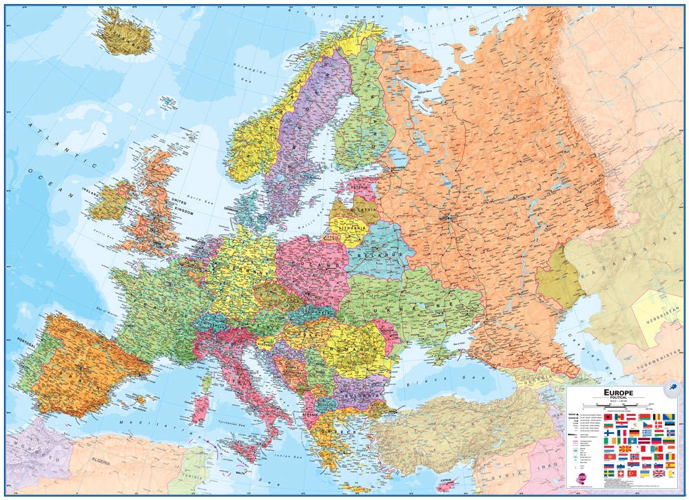
Europe is a continent of political, cultural, and physiographic diversity. This map of Europe clearly shows the continent's countries, major cities, capital cities, transportation networks, and major physical features. It is plotted at a scale of 1:4,300,000 using a Lambert Conformal Conic projection.
ADVERTISEMENT
This colorful wall map of Europe will be a great addition to your home, school, office, or conference room. Use it anywhere that a map is needed for education, display, or decor. The lamination makes it easy to hang and protects it when handled. You can also mark on it with dry erase markers and wipe it clean with a damp cloth. Many people use Post-It Notes to annotate the map, since they can be cleanly removed when finished. You can mount the map on the wall for display and quick reference, or store it rolled in its tube for occasional use.
Plan or share your trip to Europe on this map!
Use pins or removable tape to attach photos, tickets, notes, signs, flags and more.
Geography of Europe's Land and Cultural Features
This map shows all of the major cities and highway systems of Europe. City locations are indicated with symbols that are sized according to the city's population. Major highways are marked on the map as red lines, and E roads, A roads, and Motorways are marked with green route number signs. Country boundaries are solid magenta lines.
Major mountain ranges such as the Alps, Carpathians, Pyrenees, and Urals stand up boldly in shaded relief. Many other mountain ranges are visible in shaded relief and are marked by name.
Ocean and Freshwater Detail
The Europe Political Map shows ocean depths with blue color shading. Shallow areas are marked with pale blue colors and deeper areas are darker blue. This allows you to easily see that the North Sea and Barents Sea are very shallow, which is why they can support oil and natural gas drilling. Europe's many important rivers, inland lakes, and the Fjords of Scandinavia are visible on this map. In some areas like the Aegean Sea or the Croatian coast on the Adriatic Sea, there are large numbers of islands.
About the Geography of Europe
Europe occupies the western portion of the landmass known as "Eurasia". It has a broad land connection to Asia, the other half of the Eurasian landmass. Europe and Asia are unusual as continents because of this broad connection. In addition, many islands in the Atlantic Ocean, Arctic Ocean, Mediterranean Sea, Baltic Sea, and other bodies of water are considered to be part of "Europe". Because of these broad boundaries, the area known as "Europe" is arbitrarily defined and subject to disagreement among scholars, geographers and nations.
A Great Map for Home Learning
One of the most valuable uses of a map like this is in the home. When you learn about an important event in Europe while watching the news or reading a news website, you can find the location on the map. This will enrich your understanding of the event and your knowledge of European geography. This is a great map for those who are home schooling.
European Countries Shown on this Map
A total of forty-seven European countries are shown on the map. They include: Albania, Andorra, Austria, Belarus, Belgium, Bosnia and Herzegovina, Bulgaria, Croatia, Cyprus, Czech Republic, Denmark, Estonia, Finland, France, Germany, Greece, Hungary, Iceland, Ireland, Italy, Kosovo, Latvia, Liechtenstein, Lithuania, Luxembourg, Macedonia, Malta, Moldova, Monaco, Montenegro, Netherlands, Norway, Poland, Portugal, Romania, Russia, San Marino, Serbia, Slovakia, Slovenia, Spain, Sweden, Switzerland, Turkey, Ukraine, United Kingdom, and Vatican City.
How We Ship This Map to You
This is a large map and we want you to receive it in perfect condition. To do that we neatly roll it - face-inwards - and insert it into a sturdy map tube. We ship all of our laminated maps through the United States Postal Service using Ground Advantage. We ship no later than the next business day after your order is placed. We ship Ground Advantage to all customer addresses in the United States, Alaska, Hawaii, APO, FPO, and all official United States Territories. (We're sorry, but we are unable to ship any purchases to countries outside of the United States). If you order other items at the same time, your map will be shipped in a separate tube.