 Makes a great gift!
Alaska DeLorme Atlas
Complete Alaska Road Map and
Topographic Map Coverage
- Large 11" x 15.5" Pages
- Topo Maps with Back Roads
- 126 Pages of Maps
- 15 Pages of Attractions, Information and Places to Visit
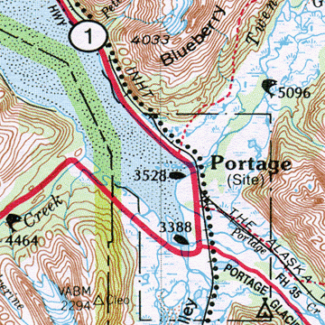
- Scale pg 16-129: 1:300,000 (1" = 4.8 miles)
- Scale pg 130-141: 1:1,400,000 (1" = 22 miles)
You can use this atlas to:
- Find RV camping sites near Willow
- Look up the daylight hours for Barrow, in September
- Explore back roads of the Alaska Panhandle
- Check the mileage between Homer and Skagway
|
Ships right away by Priority Mail
A Sample Map From This Book
Some of the Map Symbols
 |
Hiking |
 |
Campgrounds |
 |
Downhill Ski Areas |
 |
Freshwater Fishing |
 |
Float Trips |
 |
Historic Sites/Museums |
 |
Hunting - Fish & Game Offices |
 |
Highest Peaks |
 |
Saltwater Fishing |
 |
National Lands |
 |
Wildlife Refuges |
 |
Scenic Drives |
Alaska's place names and physical features, such as lakes, rivers and mountains are indexed for easy look-up. The vastness of the state is detailed in this up-to-date atlas, from the Gulf of Alaska to Barrow, the northernmost point of the United States.