Home » US Maps » Alabama » Lakes and Rivers
Alabama Lakes, Rivers and Water Resources

ADVERTISEMENT
Alabama Rivers Shown on the Map: Alabama River, Black Warrior River, Cahaba River, Chattahoochee River, Choctawhatchee River, Conecuh River, Coosa River, Locust Fork, Mulberry Fork, Pea River, Sipsey River, Tallapoosa River, Tennessee River and Tombigbee River.
Alabama Lakes Shown on the Map: Guntersville Lake, Lewis Smith Lake, Logan Martin Lake, Martin Lake, Pickwick Lake, Walter F. George Reservoir, Weiss Lake, West Point Lake, Wheeler Lake and William Dannelly Reservoir.
| Alabama Stream and River Levels |
 The United States Geological Survey has a number of stream gages located throughout Alabama. These estimate stream levels, discharges and record them over time. This data is published on the web and many stations allow users to plot custom graphs. Get updated Alabama river and stream levels from USGS here.
| Alabama Stream and River Level Alerts |
 The United States Geological Survey has a system that will send you an email message when flood levels are reached on any stream with USGS gaging equipment that you have selected. Sign up here to receive Alabama stream and river level alerts.

| Alabama Drought Map |
 The United States Geological Survey publishes updated drought maps on their website. There you can view a map that shows where below normal 7-day average stream flow conditions were recently recorded. The maps are updated daily. Get a current Alabama drought map here.
| Alabama Water Publications |
 The United States Geological Survey has a number of publications related to water use and water resources in Alabama. Visit the Lower Mississippi-Gulf Water Science Center here.
| Alabama Elevation Map |
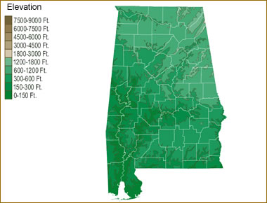 The topography of an area determines the direction of stream flow and often is a primary influence on the geographic distribution of precipitation. View a detailed Alabama elevation map.


Find Other Topics on Geology.com:

|

| ||

|

| ||

|

| ||

|

|