DNA in Ocean Water Reveals Giant Squid and Other Animals Off Australia's Coast
Smithsonian Magazine
Mucus, feces, skin and other shed tissue allowed researchers to investigate which creatures have been swimming in two deep-sea canyons without having to observe or catch them. Think about dilution and detection limits !!
Smithsonian Magazine
Mucus, feces, skin and other shed tissue allowed researchers to investigate which creatures have been swimming in two deep-sea canyons without having to observe or catch them. Think about dilution and detection limits !!
Watch: Green Fireball Meteor Lights Up the Sky Behind Mayon Volcano in Eruption
NDTV.com
Video of a rare green fireball descending behind Mayon Volcano in the Philippines on May 25, 2026 at 10:33 PM local time.
NDTV.com
Video of a rare green fireball descending behind Mayon Volcano in the Philippines on May 25, 2026 at 10:33 PM local time.
This Canadian Mine Might Release Enough Natural Hydrogen Each Year to Power 400 Homes
Smithsonian Magazine
From the article: "Many of the country's metal mines are embedded in an ancient rock formation that probably also houses a lot of the resource, referred to as 'white hydrogen'"
Smithsonian Magazine
From the article: "Many of the country's metal mines are embedded in an ancient rock formation that probably also houses a lot of the resource, referred to as 'white hydrogen'"
NOAA Forecasts a Below-Average Hurricane Season
EOS
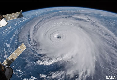
The image above is a view of Hurricane Florence strengthening as it moved above the Atlantic Ocean on September 12, 2018. It made landfall in North and South Carolina with wind speeds of 130 miles per hour on September 14, 2018. The image is an astronaut photo taken from the International Space Station. Image by NASA / Goddard Space Flight Center, displayed here under a Creative Commons License.
EOS
The image above is a view of Hurricane Florence strengthening as it moved above the Atlantic Ocean on September 12, 2018. It made landfall in North and South Carolina with wind speeds of 130 miles per hour on September 14, 2018. The image is an astronaut photo taken from the International Space Station. Image by NASA / Goddard Space Flight Center, displayed here under a Creative Commons License.
_(cropped).jpg)
AI's Insatiable Appetite for Electricity Could Revive the Use of Coal
CNBC
Quote from the article: "...the power demands (from AI data centers) are so great that the once-forsaken energy source of coal is going to come back in a big way if the utilities don’t stop President Donald Trump and the Department of Energy from forcing coal-based or coal-using companies to continue using it."
UAE to Complete the Habshan-Fujairah Pipeline Bypassing Strait of Hormuz by 2027
The Guardian
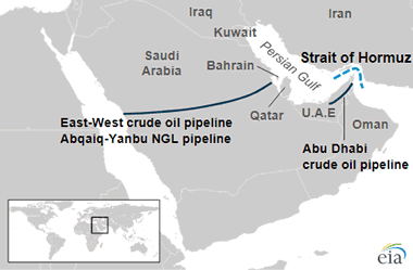
From the article: "State oil company fast-tracks previously undisclosed project, which is expected to double export capacity - but will not be ready until 2027. Map by the United States Energy Information Administration."
The Guardian
From the article: "State oil company fast-tracks previously undisclosed project, which is expected to double export capacity - but will not be ready until 2027. Map by the United States Energy Information Administration."
Extensive Desert ‘Lava Tubes’ Sheltered Humans for 7,000 Years
Smithsonian Magazine
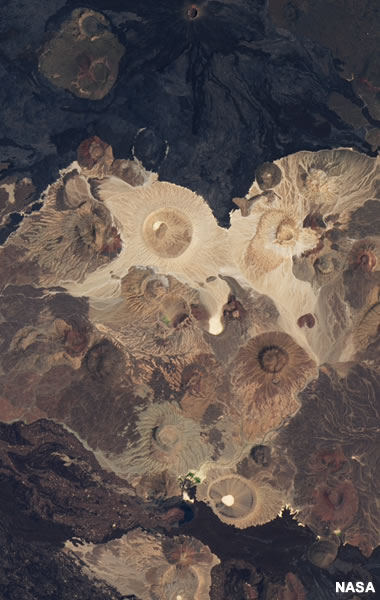
From the article: "Formed after volcanic activity, the underground caves periodically hosted early humans and their livestock in Saudi Arabia, facilitating cultural exchange." The satellite image of a portion of the Harrat Khaybar lava fields - public domain image by NASA.
More! Photos of rock art from Umm Jarsan, a cave in the Harrat Khaybar Lava Fields.
Smithsonian Magazine
From the article: "Formed after volcanic activity, the underground caves periodically hosted early humans and their livestock in Saudi Arabia, facilitating cultural exchange." The satellite image of a portion of the Harrat Khaybar lava fields - public domain image by NASA.
More! Photos of rock art from Umm Jarsan, a cave in the Harrat Khaybar Lava Fields.
Cave of the Hands
Geology.com

Cave of the Hands is a series of caves in Argentina where ancient people painted on the walls thousands of years ago. Image copyright iStockphoto / edurivero.
Geology.com
Cave of the Hands is a series of caves in Argentina where ancient people painted on the walls thousands of years ago. Image copyright iStockphoto / edurivero.
Keshia Smith Found a 3-Carat Uncut Diamond in an Arkansas State Park
The Washington Post
From the article: "Crater of Diamonds State Park is located near Murfreesboro, Arkansas and draws about 100,000 visitors annually."
The Washington Post
From the article: "Crater of Diamonds State Park is located near Murfreesboro, Arkansas and draws about 100,000 visitors annually."
Diamond Mines in the United States
Geology.com
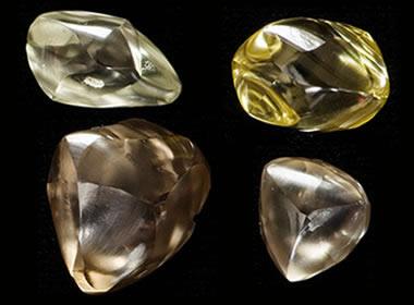
A photograph of several diamonds found at the Crater of Diamonds State Park, near Murfreesboro, Arkansas. These diamonds were probably nicely formed crystals when they were in the Earth's mantle. Their shapes were modified by corrosive fluids during their rapid ascent to Earth's surface. Photo used with permission of Crater of Diamonds State Park.
NOTE: Crater of Diamonds is a fee mining site where you can pay a fee and look for diamonds. It is the only diamond mine in the world where YOU can be the miner.
Geology.com
A photograph of several diamonds found at the Crater of Diamonds State Park, near Murfreesboro, Arkansas. These diamonds were probably nicely formed crystals when they were in the Earth's mantle. Their shapes were modified by corrosive fluids during their rapid ascent to Earth's surface. Photo used with permission of Crater of Diamonds State Park.
NOTE: Crater of Diamonds is a fee mining site where you can pay a fee and look for diamonds. It is the only diamond mine in the world where YOU can be the miner.
10 Winning Photos from the 2026 Milky Way Photographer of the Year Contest
Smithsonian Magazine
See ten amazing photos that capture the beauty of our galaxy. The scenes were photographed from locations that include Australia, Botswana, Italy, New Zealand, and the U.S. state of Florida.
Smithsonian Magazine
See ten amazing photos that capture the beauty of our galaxy. The scenes were photographed from locations that include Australia, Botswana, Italy, New Zealand, and the U.S. state of Florida.
Aurora Australis from Space
Geology.com
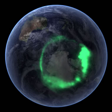
Aurora Australis: A composite satellite image of the Aurora Australis (southern lights) over Antarctica from space. The image was compiled by superimposing data of the Aurora Australis collected by NASA's IMAGE satellite atop of an image of Earth from a south polar perspective from the Blue Marble project. The result simulates what the Aurora Australis would look like from a satellite orbiting above. Image by NASA.
Geology.com
Aurora Australis: A composite satellite image of the Aurora Australis (southern lights) over Antarctica from space. The image was compiled by superimposing data of the Aurora Australis collected by NASA's IMAGE satellite atop of an image of Earth from a south polar perspective from the Blue Marble project. The result simulates what the Aurora Australis would look like from a satellite orbiting above. Image by NASA.
Mexico City Is Sinking so Quickly, It Can Be Seen From Space
AP
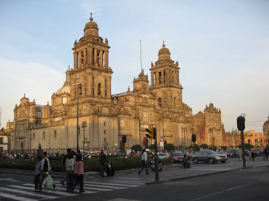
Quote from the article: "Mexico City is sinking by nearly 10 inches (about 25 centimeters) a year, according to new satellite imagery released this week by NASA, making it one of the world’s fastest-subsiding metropolises." About the photo: The Metropolitan Cathedral in Mexico City. Photograph by Juan Fernando Ibarra and released into the Public Domain.
AP
Quote from the article: "Mexico City is sinking by nearly 10 inches (about 25 centimeters) a year, according to new satellite imagery released this week by NASA, making it one of the world’s fastest-subsiding metropolises." About the photo: The Metropolitan Cathedral in Mexico City. Photograph by Juan Fernando Ibarra and released into the Public Domain.
US-Indian Space Mission Maps Extreme Subsidence in Mexico City
NASA
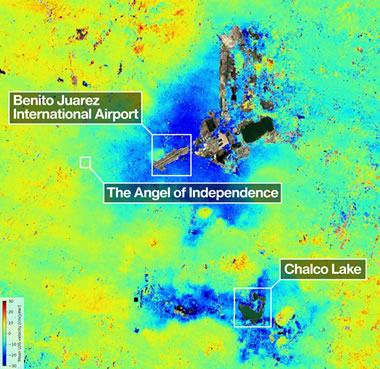
From the article: "One of the most powerful radar systems ever launched into space has mapped the ground moving beneath one of fastest subsiding capitals in the world: Mexico City. "
NASA
From the article: "One of the most powerful radar systems ever launched into space has mapped the ground moving beneath one of fastest subsiding capitals in the world: Mexico City. "
New Earthquake Model Goes Against the Grain
Eos
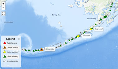
From the article: "Subducting plates are stronger in certain directions than in others, which may be a factor in how earthquakes occur and how seismic waves propagate." The accompanying map shows volcanic islands along the Aleutian Trench. Map by the Alaska Volcano Observatory, United States Geological Survey.
Eos
From the article: "Subducting plates are stronger in certain directions than in others, which may be a factor in how earthquakes occur and how seismic waves propagate." The accompanying map shows volcanic islands along the Aleutian Trench. Map by the Alaska Volcano Observatory, United States Geological Survey.
What a Solar Superstorm Could Mean for the United States
United States Geological Survey
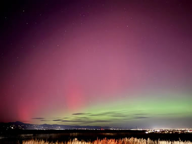
From the article: "If a geomagnetic storm as large as the famed “Carrington Event” of 1859 were to occur today, it could adversely affect telecommunications and electric power transmission systems across the U.S., especially in the Midwest and the East Coast." About the photo: Northern lights draping across the Colorado Sky, November, 2025. Photograph by Gavin P. Hayes, United States Geological Survey, Public Domain.
United States Geological Survey
From the article: "If a geomagnetic storm as large as the famed “Carrington Event” of 1859 were to occur today, it could adversely affect telecommunications and electric power transmission systems across the U.S., especially in the Midwest and the East Coast." About the photo: Northern lights draping across the Colorado Sky, November, 2025. Photograph by Gavin P. Hayes, United States Geological Survey, Public Domain.
It Took Millions of Years for Australia’s Twelve Apostles Landmark to Rise Out of the Sea
Smithsonian Magazine
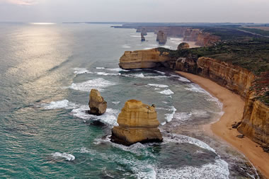
From the article: "The iconic tourist destination provides a beautiful view, but also represents a physical record of Earth’s climate history." About the photo: A photograph of The Twelve Apostles, Port Campbell National Park, Victoria, Australia. Photo by Michael J. Fromholtz, displayed here under a Creative Commons License.
Smithsonian Magazine
From the article: "The iconic tourist destination provides a beautiful view, but also represents a physical record of Earth’s climate history." About the photo: A photograph of The Twelve Apostles, Port Campbell National Park, Victoria, Australia. Photo by Michael J. Fromholtz, displayed here under a Creative Commons License.
Before Planning International Travel, Check this Travel Advisories Map
U.S. Department of State

If you're an American who is planning a trip outside of the U.S., first you should check out this travel advisories map. You can click on a country to see what security risks may be present there, including crime, civil unrest, or natural disasters, as well as any specific areas to avoid. There is also country-specific information about local laws and customs, travel requirements, health and transportation, U.S. Embassy locations, and more. The interactive map on the government website is updated daily.
U.S. Department of State
If you're an American who is planning a trip outside of the U.S., first you should check out this travel advisories map. You can click on a country to see what security risks may be present there, including crime, civil unrest, or natural disasters, as well as any specific areas to avoid. There is also country-specific information about local laws and customs, travel requirements, health and transportation, U.S. Embassy locations, and more. The interactive map on the government website is updated daily.
Scientists Training to Dive Beneath Polar Ice
Associated Press
From the article: "As the Arctic is warming four times faster than the rest of the planet, the Finnish Scientific Diving Academy is on a mission to train the next generation of scientists and researchers to dive beneath the Arctic and Antarctic ice to study the flora and fauna below. It also aims to convince the world that the polar ice crisis requires additional research."
Climbers Attempting to Climb Everest Despite Increasing Challenges
Associated Press
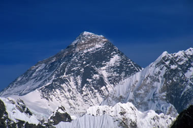
From the article: "Hundreds of climbers are attempting to scale Mount Everest, the world’s highest peak, despite an unstable ice block dangerously hanging over the key trail, high travel costs and increased permit fees." About the photo: Everest from Gokyo Ri: A clear-sky view of the Mount Everest summit through a telephoto lens from the summit of Gokyo Ri. Image copyright iStockphoto / Grazyna Niedzieska.
Associated Press
From the article: "Hundreds of climbers are attempting to scale Mount Everest, the world’s highest peak, despite an unstable ice block dangerously hanging over the key trail, high travel costs and increased permit fees." About the photo: Everest from Gokyo Ri: A clear-sky view of the Mount Everest summit through a telephoto lens from the summit of Gokyo Ri. Image copyright iStockphoto / Grazyna Niedzieska.
France’s Deepest Shipwreck, a 16th-Century Merchant Vessel Under the Mediterranean
Smithsonian Magazine
From the article: "Known as the “Camarat 4,” the ship was loaded with cannons, cauldrons and hundreds of ceramics—which are still visible on the seafloor. Researchers are surveying the site and carefully recovering a small selection of artifacts."
Smithsonian Magazine
From the article: "Known as the “Camarat 4,” the ship was loaded with cannons, cauldrons and hundreds of ceramics—which are still visible on the seafloor. Researchers are surveying the site and carefully recovering a small selection of artifacts."
East Africa Might Break from the Continent Sooner Than Thought
-- and a New Ocean May Fill the Gap
Smithsonian Magazine
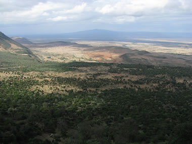
From the article: "A new study suggests that a rift in Kenya and Ethiopia has reached a critical stage in the split-up process, and that water may flood it in a few million years." About the photo: "A view of the Great Rift Valley in Kenya. The Great Rift Valley is a name given in the late 19th century by British explorer John Walter Gregory to the continuous geographic trench, approximately 6,000 kilometres (3,700 mi) in length, that runs from northern Syria in Southwest Asia to central Mozambique in East Africa. Photograph by Shankar S., used here under a Creative Commons License.
-- and a New Ocean May Fill the Gap
Smithsonian Magazine
From the article: "A new study suggests that a rift in Kenya and Ethiopia has reached a critical stage in the split-up process, and that water may flood it in a few million years." About the photo: "A view of the Great Rift Valley in Kenya. The Great Rift Valley is a name given in the late 19th century by British explorer John Walter Gregory to the continuous geographic trench, approximately 6,000 kilometres (3,700 mi) in length, that runs from northern Syria in Southwest Asia to central Mozambique in East Africa. Photograph by Shankar S., used here under a Creative Commons License.
.jpg)
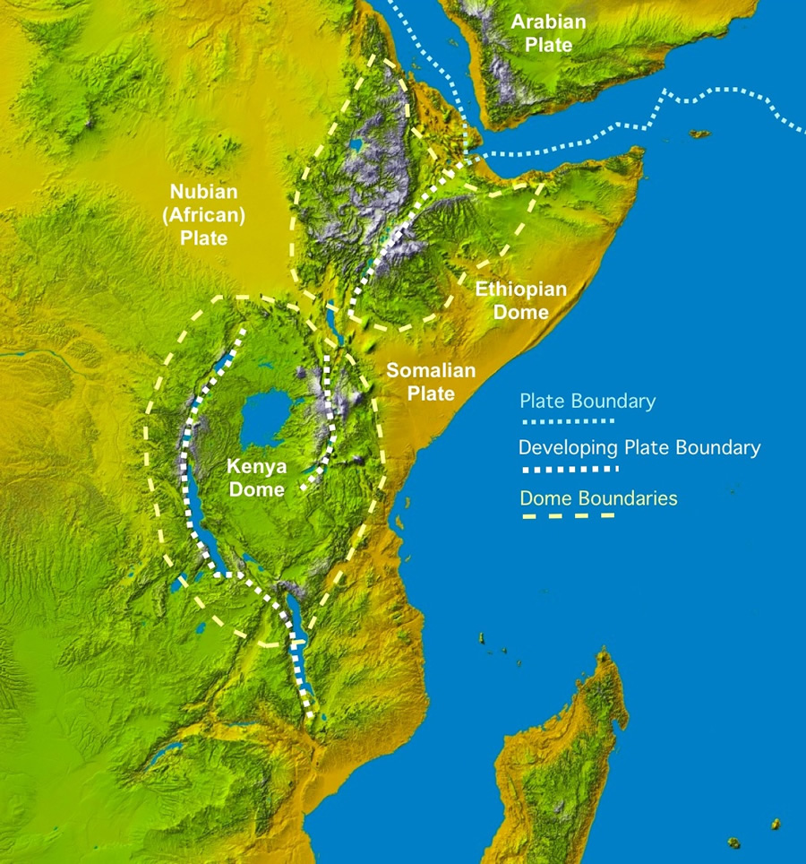
East Africa's Great Rift Valley: A Complex Rift System
Geology.com
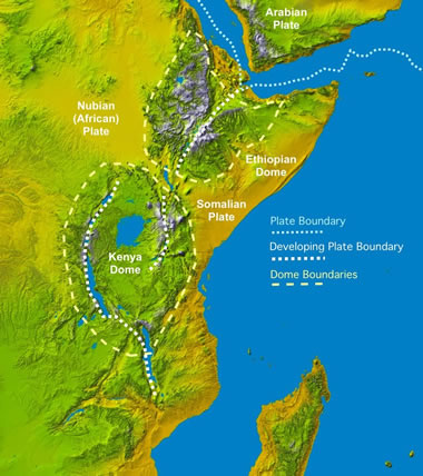
Colored Digital Elevation Model showing tectonic plate boundaries, outlines of the elevation highs demonstrating the thermal bulges and large lakes of East Africa. Enlarge Image. The basemap is a Space Shuttle radar topography image by NASA.
Geology.com
Colored Digital Elevation Model showing tectonic plate boundaries, outlines of the elevation highs demonstrating the thermal bulges and large lakes of East Africa. Enlarge Image. The basemap is a Space Shuttle radar topography image by NASA.
Color Off the Mid-Atlantic Coast
NASA Earth Observatory
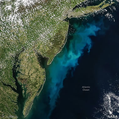
Shown above is a large phytoplankton bloom in the Atlantic Ocean, off the coasts of Delaware, Maryland, New Jersey, and Virginia. This image was captured by the MODIS (Moderate Resolution Imaging Spectroradiometer) on NASA's Aqua satellite on May 3, 2026. Image by NASA Earth Observatory / Michala Garrison.
NASA Earth Observatory
Shown above is a large phytoplankton bloom in the Atlantic Ocean, off the coasts of Delaware, Maryland, New Jersey, and Virginia. This image was captured by the MODIS (Moderate Resolution Imaging Spectroradiometer) on NASA's Aqua satellite on May 3, 2026. Image by NASA Earth Observatory / Michala Garrison.
Satellite Views of Phytoplankton Blooms in Oceans and Seas
Geology.com

Phytoplankton Bloom Off New Jersey: An unusual phytoplankton bloom occurred in the Atlantic Ocean off the coast of New Jersey on July 6, 2016. This bloom received nutrients from a process known as "upwelling". Strong, persistent winds, blowing off the continent and towards the east, carried surface waters away from the coast. This brought cold, nutrient-rich waters up the continental slope to replace the waters that were blown out to sea. The result was a near-shore phytoplankton bloom. Similar blooms occur periodically along the Atlantic coast in the summer. This NASA satellite image was prepared by Jeff Schmaltz.
Geology.com
Phytoplankton Bloom Off New Jersey: An unusual phytoplankton bloom occurred in the Atlantic Ocean off the coast of New Jersey on July 6, 2016. This bloom received nutrients from a process known as "upwelling". Strong, persistent winds, blowing off the continent and towards the east, carried surface waters away from the coast. This brought cold, nutrient-rich waters up the continental slope to replace the waters that were blown out to sea. The result was a near-shore phytoplankton bloom. Similar blooms occur periodically along the Atlantic coast in the summer. This NASA satellite image was prepared by Jeff Schmaltz.
10 Interesting Creatures Named After Sir David Attenborough
Smithsonian Magazine

Sir David Attenborough is an English broadcaster and naturalist. His documentaries have captivated audiences for over 70 years. To celebrate David's 100th birthday, Smithsonian highlights a few of the many organisms that have been given his namesake. Shown above is Euptychia attenboroughi, a rare butterfly from the Amazon basin. Image by A.F.E. Neild et al., ZooKeys, 2015, displayed here under a Creative Commons License.
Smithsonian Magazine
Sir David Attenborough is an English broadcaster and naturalist. His documentaries have captivated audiences for over 70 years. To celebrate David's 100th birthday, Smithsonian highlights a few of the many organisms that have been given his namesake. Shown above is Euptychia attenboroughi, a rare butterfly from the Amazon basin. Image by A.F.E. Neild et al., ZooKeys, 2015, displayed here under a Creative Commons License.
_en_ventral_(right).jpg)
Could Pluto Once Again Be Considered a Planet?
Smithsonian Magazine
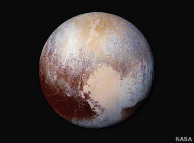
From the article: "Two decades ago, the International Astronomical Union - which defines and names celestial bodies - redefined the criteria for being a planet, putting Pluto into the new category of dwarf planet." Shown above is an image of Pluto captured by the New Horizons expedition, the first expedition to explore Pluto "up close". Image by the NASA New Horizons Mission.
Smithsonian Magazine
From the article: "Two decades ago, the International Astronomical Union - which defines and names celestial bodies - redefined the criteria for being a planet, putting Pluto into the new category of dwarf planet." Shown above is an image of Pluto captured by the New Horizons expedition, the first expedition to explore Pluto "up close". Image by the NASA New Horizons Mission.
The Largest Viking Age Hoard Ever Found in Norway
Smithsonian Magazine
Quote from the article: "Buried in the mid-11th century, the stash includes silver pieces minted under rulers such as Cnut the Great, Aethelred the Unready and Harald Hardrada."
Smithsonian Magazine
Quote from the article: "Buried in the mid-11th century, the stash includes silver pieces minted under rulers such as Cnut the Great, Aethelred the Unready and Harald Hardrada."
Where Is Norway?
Geology.com
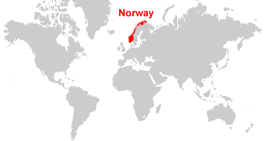
Norway is located in northern Europe. Norway is bordered by the North Sea and the Norwegian Sea, and Sweden to the east.
Geology.com
Norway is located in northern Europe. Norway is bordered by the North Sea and the Norwegian Sea, and Sweden to the east.
The Many Uses of Silver
Geology.com

When most people hear the word "silver", they probably think of jewelry and coins. However, silver has unique properties that make it very useful for many different industrial applications. Images copyright iStockphoto / Jorge Farres Sanchez, Tatiana Buzuleac, Nigel Spooner, and Stephanie Frey.
Geology.com
When most people hear the word "silver", they probably think of jewelry and coins. However, silver has unique properties that make it very useful for many different industrial applications. Images copyright iStockphoto / Jorge Farres Sanchez, Tatiana Buzuleac, Nigel Spooner, and Stephanie Frey.
An Atmosphere Around a Tiny, Icy World Beyond Pluto?
NBC News
Quote from the article: "A new study suggests that a tiny, icy world beyond Pluto harbors a thin, delicate atmosphere that may have been created by volcanic eruptions or a comet strike."
NBC News
Quote from the article: "A new study suggests that a tiny, icy world beyond Pluto harbors a thin, delicate atmosphere that may have been created by volcanic eruptions or a comet strike."
Zircon Crystals Hint at a Possible Origin Story for the Grand Canyon
Smithsonian Magazine
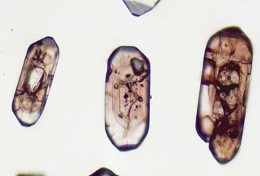
Many zircon crystals contain traces of uranium and thorium. These elements decay at a predictable rate and can be used to estimate the age of the crystals. Scientists found that sandstone samples from the Bidahochi Basin of Arizona contained zircon crystals that are a close match to crystals from early Colorado River sediments. Quote from the article: "This discovery suggests that the sandstone in the Bidahochi Basin was once sediment deposited by the Colorado River." The image above shows zircon grains that are over a billion years old. If you look closely, you can see "age zones" within the grains. Image by John Aleinikoff, USGS.
Smithsonian Magazine
Many zircon crystals contain traces of uranium and thorium. These elements decay at a predictable rate and can be used to estimate the age of the crystals. Scientists found that sandstone samples from the Bidahochi Basin of Arizona contained zircon crystals that are a close match to crystals from early Colorado River sediments. Quote from the article: "This discovery suggests that the sandstone in the Bidahochi Basin was once sediment deposited by the Colorado River." The image above shows zircon grains that are over a billion years old. If you look closely, you can see "age zones" within the grains. Image by John Aleinikoff, USGS.
Zircon - Gemstone, Mineral, and Ore of Zirconium
Geology.com
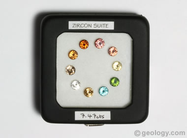
Zircon is a mineral and is the primary ore of zirconium. It is also a gemstone that is available in many colors. In 1952, zircon was designated as a birthstone for the month of December.
Geology.com
Zircon is a mineral and is the primary ore of zirconium. It is also a gemstone that is available in many colors. In 1952, zircon was designated as a birthstone for the month of December.
How Old Is the Grand Canyon?
Geology.com
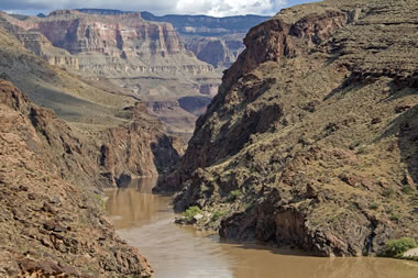
In this article, award-winning author Wayne Ranney explores the Grand Canyon's age. The photo above shows the Colorado River flowing through the Grand Canyon. Photo copyright Wayne Ranney.
Geology.com
In this article, award-winning author Wayne Ranney explores the Grand Canyon's age. The photo above shows the Colorado River flowing through the Grand Canyon. Photo copyright Wayne Ranney.
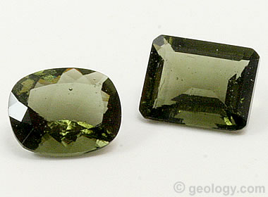
Emerald: Birthstone for May
Geology.com
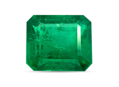
Emerald is the traditional birthstone for the month of May. Emerald is a green variety of the beryl mineral family. It is the world's most popular green gem. Image copyright iStockphoto / mikheewnik.
Geology.com
Emerald is the traditional birthstone for the month of May. Emerald is a green variety of the beryl mineral family. It is the world's most popular green gem. Image copyright iStockphoto / mikheewnik.
Sherpas Cross Icefall, Open Route for Climbers to Move Up on Everest
Reuters
For the past two weeks, hundreds of hopeful mountaineers have been stuck at Mount Everest base camp because a huge column of glacial ice (called a "serac") was blocking the path. Now, the serac is finally melting, allowing the highly skilled "icefall doctors" to begin creating a path of ropes and ladders up the mountain. This is great news for the eager climbers. However, the delay could lead to dangerous crowding along the route, since a larger number of climbers will now be attempting to summit the mountain within a smaller window of time.
The Highest Mountain in the World
Geology.com
Mount Everest is the highest mountain in the world... or is it? Depending upon how you define "highest mountain," Mount Everest has some rivals! Shown above is a clear-sky view of the Mount Everest summit. Image copyright iStockphoto / Grazyna Niedzieska.
Geology.com
Mount Everest is the highest mountain in the world... or is it? Depending upon how you define "highest mountain," Mount Everest has some rivals! Shown above is a clear-sky view of the Mount Everest summit. Image copyright iStockphoto / Grazyna Niedzieska.
These Modern-Day Photographs Highlight Why, Centuries Later,
Pompeii Still Attracts Throngs of Tourists and Archaeologists
Smithsonian Magazine
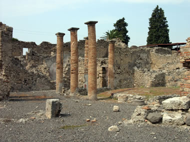
Quote from the article: "The eruption of Mt. Vesuvius froze the ancient Roman city in time, giving modern-day humans a remarkable vision into the past." About the photo: Brick columns stand among ruins of the ancient city of Pompeii. Image copyright iStockphoto / Evgeny Bortnikov.
Pompeii Still Attracts Throngs of Tourists and Archaeologists
Smithsonian Magazine
Quote from the article: "The eruption of Mt. Vesuvius froze the ancient Roman city in time, giving modern-day humans a remarkable vision into the past." About the photo: Brick columns stand among ruins of the ancient city of Pompeii. Image copyright iStockphoto / Evgeny Bortnikov.
Mount Vesuvius: The Volcano that Buried Pompeii
Geology.com
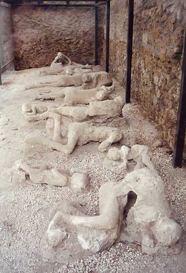
Plaster casts of people who died in the city of Pompeii during the 79 AD eruption of Mount Vesuvius. They were buried in volcanic ash. Image: Garden of the Fugitives. This photo was taken by Lancevortex and is distributed under a GNU Free Documentation License.
Geology.com
Plaster casts of people who died in the city of Pompeii during the 79 AD eruption of Mount Vesuvius. They were buried in volcanic ash. Image: Garden of the Fugitives. This photo was taken by Lancevortex and is distributed under a GNU Free Documentation License.
Thríhnúkagígur: The Only Volcano on Earth Where You Can Descend into a Magma Chamber
Live Science
Quote from the article: "Thríhnúkagígur is a volcano near Reykjavík in Iceland with an empty magma chamber decorated with vivid colors that scientists and tourists can access via an open cable elevator."
Live Science
Quote from the article: "Thríhnúkagígur is a volcano near Reykjavík in Iceland with an empty magma chamber decorated with vivid colors that scientists and tourists can access via an open cable elevator."
Strait of Hormuz: With Hunger Looming, Life-Saving Fertilizer Shipments Cannot Wait
United Nations
Quote from the article: "The purpose is to avoid a humanitarian crisis...There is a clear nexus between the lack of access to fertilizers and the disruption of food systems."
United Nations
Quote from the article: "The purpose is to avoid a humanitarian crisis...There is a clear nexus between the lack of access to fertilizers and the disruption of food systems."
Why the Strait of Hormuz Is Disrupting Global Agriculture
Democracy Now!
Quote from the article.... "closure of the Strait of Hormuz has raised fuel costs and caused shortages of key fertilizers around the world, wreaking havoc on the agricultural industry."
Democracy Now!
Quote from the article.... "closure of the Strait of Hormuz has raised fuel costs and caused shortages of key fertilizers around the world, wreaking havoc on the agricultural industry."
Scientists Make Breakthrough in Solving the Mystery of Volcanic Lightning
The Guardian
From the article: "Research shows fine carbon coating on silica in updraught causes electrical charge – and spectacular display"
The Guardian
From the article: "Research shows fine carbon coating on silica in updraught causes electrical charge – and spectacular display"
A School of Mud Volcano Islands in Azerbaijan
NASA Earth Observatory
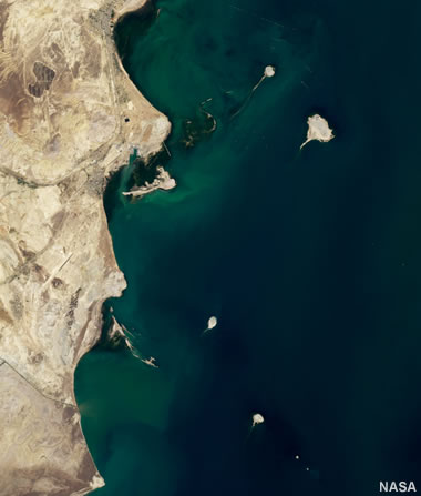
There are hundreds of mud volcanoes in the country of Azerbaijan. In the satellite image above, we see four tadpole-shaped islands that were created by eruptions from underwater mud volcanoes. These mud volcanoes can erupt violently and without warning, sometimes creating brand-new islands in a matter of minutes.
NASA Earth Observatory
There are hundreds of mud volcanoes in the country of Azerbaijan. In the satellite image above, we see four tadpole-shaped islands that were created by eruptions from underwater mud volcanoes. These mud volcanoes can erupt violently and without warning, sometimes creating brand-new islands in a matter of minutes.
Where Is Azerbaijan?
Geology.com
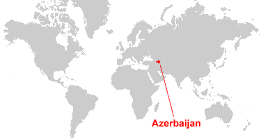
Azerbaijan is located in southwestern Asia. Azerbaijan is bordered by the Caspian Sea to the east, Russia and Georgia to the north, Armenia and Turkey to the west, and Iran to the south.
Geology.com
Azerbaijan is located in southwestern Asia. Azerbaijan is bordered by the Caspian Sea to the east, Russia and Georgia to the north, Armenia and Turkey to the west, and Iran to the south.
Celebrate Earth Day!
EARTHDAY.ORG

April 22 is Earth Day, and EARTHDAY.ORG has compiled a variety of resources "designed for students, families, workplaces, faith groups, and communities everywhere." Find toolkits, quizzes, fact sheets, ways to take action, and more. Shown above is an image from Google Earth, a free program that you can use to explore the surface of our planet.
EARTHDAY.ORG
April 22 is Earth Day, and EARTHDAY.ORG has compiled a variety of resources "designed for students, families, workplaces, faith groups, and communities everywhere." Find toolkits, quizzes, fact sheets, ways to take action, and more. Shown above is an image from Google Earth, a free program that you can use to explore the surface of our planet.
Newly Discovered Prehistoric Stone Tools Were Made from Geodes and Fossils
Smithsonian Magazine
Archaeologists discovered a cache of hand axes in the Sakhnin Valley of Israel. Some of the tools were crafted from rocks which contain fossils or geodes. From the article: "The researchers say the cache represents the largest concentration of fossil- and geode-bearing stone tools discovered to date."
Mars Curiosity Rover Stumbles Upon Evidence of Ancient Martian Winds
EOS
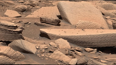
Quote from the article: "Researchers have found evidence of a sandstorm on Mars that occurred about 3.6 billion years ago, marking the first time a sandstorm has been recognized in the Martian stratigraphic record." Photograph of rocks found on the surface of Mars that recorded evidence of a sandstorm which occurred over 3 billion years ago. Photo by NASA/JPL-Caltech/MSSS.
EOS
Quote from the article: "Researchers have found evidence of a sandstorm on Mars that occurred about 3.6 billion years ago, marking the first time a sandstorm has been recognized in the Martian stratigraphic record." Photograph of rocks found on the surface of Mars that recorded evidence of a sandstorm which occurred over 3 billion years ago. Photo by NASA/JPL-Caltech/MSSS.
Landsat 9: More Than Just A Picture
NASA
This is a brief history of NASA's Landsat program. Satellite imagery provides 24/7 data about our ever-changing planet. These images and data are useful for a wide variety of applications.
NASA
This is a brief history of NASA's Landsat program. Satellite imagery provides 24/7 data about our ever-changing planet. These images and data are useful for a wide variety of applications.
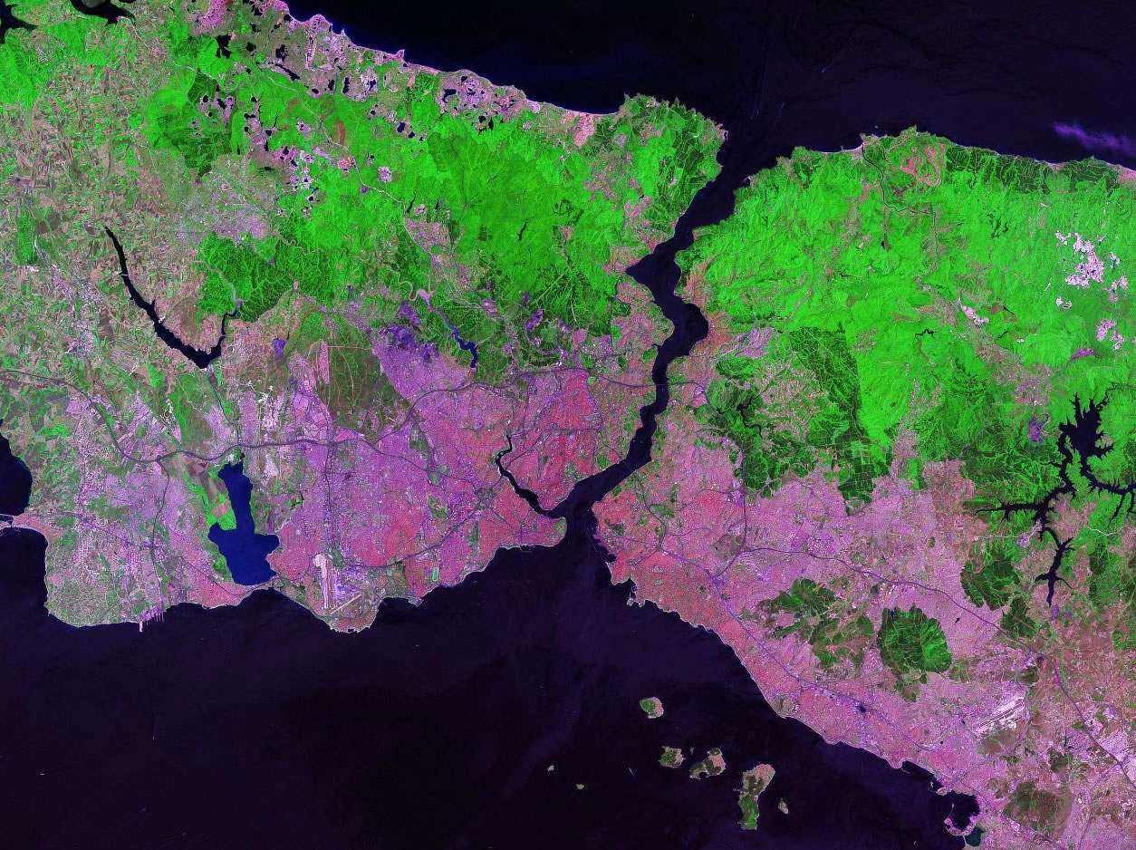
Satellite Images on Geology.com
Geology.com

Our website has hundreds of satellite images for you to browse, including images of U.S. States, U.S. Cities, World Cities, phytoplankton blooms, and more.
Shown above, clockwise from top left: New Orleans, Louisiana; the state of Oregon; Europe at night; Istanbul, Turkey; Egypt; and man-made islands of Dubai, U.A.E.
Geology.com
Our website has hundreds of satellite images for you to browse, including images of U.S. States, U.S. Cities, World Cities, phytoplankton blooms, and more.
Shown above, clockwise from top left: New Orleans, Louisiana; the state of Oregon; Europe at night; Istanbul, Turkey; Egypt; and man-made islands of Dubai, U.A.E.
Top 5 Discoveries from the Hell Creek Formation Fossil Bed
Smithsonian Magazine
The Hell Creek Formation stretches across the states of Montana, North Dakota, South Dakota, and Wyoming. Countless important fossils have been found in this geologic formation. This article highlights "a sampling of the Hell Creek Formation discoveries that have changed the way we understand the prehistoric past."
Super Typhoon Sinlaku
NASA Earth Observatory
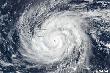
Super Typhoon Sinlaku is unusual because for this time of year, it is an exceptionally strong storm (equivalent to a Saffir-Simpson category 5). In the image above, the storm spins over the U.S. Territories of the Mariana Islands and Guam in the North Pacific Ocean. NASA Earth Observatory image by Michala Garrison, using VIIRS data from NASA EOSDIS LANCE, GIBS/Worldview, and the Suomi National Polar-orbiting Partnership.
NASA Earth Observatory
Super Typhoon Sinlaku is unusual because for this time of year, it is an exceptionally strong storm (equivalent to a Saffir-Simpson category 5). In the image above, the storm spins over the U.S. Territories of the Mariana Islands and Guam in the North Pacific Ocean. NASA Earth Observatory image by Michala Garrison, using VIIRS data from NASA EOSDIS LANCE, GIBS/Worldview, and the Suomi National Polar-orbiting Partnership.
U.S. Territories Map
Geology.com
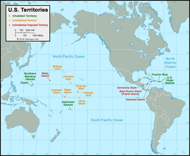
Did you know that the United States holds claim to 16 territories? How many of them can you name? Brush up on your geography with this map and article.
Geology.com
Did you know that the United States holds claim to 16 territories? How many of them can you name? Brush up on your geography with this map and article.
See the 2,000-Year-Old Ancient Roman Cargo From an Accidental Shipwreck
Discovered at the Bottom of a Lake in Switzerland
Smithsonian Magazine
Divers discovered a variety of items that may have been cargo on a civilian merchant ship, including ceramic plates and goblets, two swords, metal tools, chariot wheels, a belt buckle, a wicker basket, fragments of amphora jugs, and more. The artifacts were found at the bottom of Lake Neuchatel, located in the northwestern part of Switzerland.
Faster Detection of Tropical Forest Loss
NASA Earth Observatory
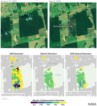
According to the United Nations Environment Programme, an average of 10 million hectacres of tropical forests are lost each year - that's an area about the size of Kentucky. To help stop unregulated forest clearing in the Brazilian Amazon, scientists at NASA have developed a new method of monitoring that combines traditional satellite imagery with radar data. The radar can "see" through cloud cover to detect deforestation in its early stages, before extensive damage has occurred. NASA Earth Observatory images by Michala Garrison, using MODIS data from NASA EOSDIS LANCE and GIBS/Worldview, the Harmonized Landsat and Sentinel-2 (HLS) product, and model data provided by Flores-Anderson et al.
NASA Earth Observatory
According to the United Nations Environment Programme, an average of 10 million hectacres of tropical forests are lost each year - that's an area about the size of Kentucky. To help stop unregulated forest clearing in the Brazilian Amazon, scientists at NASA have developed a new method of monitoring that combines traditional satellite imagery with radar data. The radar can "see" through cloud cover to detect deforestation in its early stages, before extensive damage has occurred. NASA Earth Observatory images by Michala Garrison, using MODIS data from NASA EOSDIS LANCE and GIBS/Worldview, the Harmonized Landsat and Sentinel-2 (HLS) product, and model data provided by Flores-Anderson et al.
What Will Happen to the Final Diavik Diamond?
JCK Online
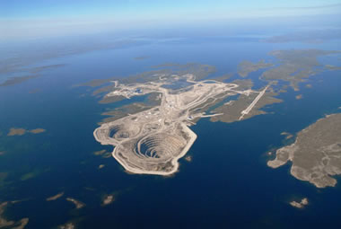
After 23 years, Canada's Diavik Diamond Mine has extracted its final batch of ore. As operations are being wrapped up, some people wonder what will become of the very last Diavik diamonds. The image above is an aerial photo of the mine, courtesy of The Diavik Diamond Mine.
JCK Online
After 23 years, Canada's Diavik Diamond Mine has extracted its final batch of ore. As operations are being wrapped up, some people wonder what will become of the very last Diavik diamonds. The image above is an aerial photo of the mine, courtesy of The Diavik Diamond Mine.
Diamond Mines in Canada
Geology.com
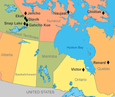
A map of Canadian diamond mines showing the approximate location of nine mines. Since producing its first commercial diamond in 1998, Canada has become one of the world's most important producers of gem-quality diamonds. Map by Geology.com and MapResources.
Geology.com
A map of Canadian diamond mines showing the approximate location of nine mines. Since producing its first commercial diamond in 1998, Canada has become one of the world's most important producers of gem-quality diamonds. Map by Geology.com and MapResources.
Trove of Fossils Found in Texas Cave
Smithsonian Magazine
A man exploring a cavern near San Antonio, Texas was surprised to find a multitude of fossils in an underground stream. Some of the fossils are unusual because they belong to animals that are not typically associated with this geographic region.
Smithsonian Magazine
A man exploring a cavern near San Antonio, Texas was surprised to find a multitude of fossils in an underground stream. Some of the fossils are unusual because they belong to animals that are not typically associated with this geographic region.
Articles About Fossils
Geology.com
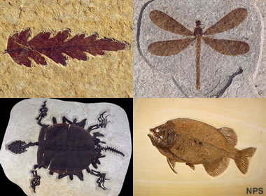
Visit our Fossils page to learn about different kinds of fossils and fossilized materials! Shown above are examples of a fossilized leaf, insect, fish, and turtle from the Green River Formation. Photos by the National Park Service.
Geology.com
Visit our Fossils page to learn about different kinds of fossils and fossilized materials! Shown above are examples of a fossilized leaf, insect, fish, and turtle from the Green River Formation. Photos by the National Park Service.
Diamond: Birthstone for April
Geology.com

Diamond is the traditional birthstone for the month of April. These days, a person born in April has many options for birthstone jewelry. Lab-grown diamonds are more affordable than natural diamonds, and they are available in a variety of colors. Another option is a natural colored diamond - if you are willing to pay a premium price. Image copyright iStockphoto / Greg Stanfield.
Geology.com
Diamond is the traditional birthstone for the month of April. These days, a person born in April has many options for birthstone jewelry. Lab-grown diamonds are more affordable than natural diamonds, and they are available in a variety of colors. Another option is a natural colored diamond - if you are willing to pay a premium price. Image copyright iStockphoto / Greg Stanfield.
Diamond Mines in the United States
Geology.com
A photograph of several diamonds found at the Crater of Diamonds State Park, near Murfreesboro, Arkansas. These diamonds were probably nicely formed crystals when they were in the Earth's mantle. Their shapes were modified by corrosive fluids during their rapid ascent to Earth's surface. Photo used with permission of Crater of Diamonds State Park.
NOTE: Crater of Diamonds is a fee mining site where you can pay a fee and look for diamonds. It is the only diamond mine in the world where YOU can be the miner.
National Gas Average Jumps One Dollar in One Month
American Automobile Association
Most Americans who drive a gas-powered vehicle have witnessed rising prices at the pump. At the time of this post, the National Average Gas Price has surpassed $4 per gallon - a price that hasn't been seen since August 2022. This article from AAA provides some context and details.
AAA has also created a color-coded map of the United States that shows which states have the highest and lowest gas prices. Click here to see the AAA gas prices map (updated daily).
What Determines Gas Prices?
EIA.gov on YouTube
Did you know that the cost of crude oil only accounts for about 55% of the price of gasoline? Other things that affect the price are the costs of refining the crude oil, distribution and marketing costs, and taxes. This short video shows how these different factors add up to the final price you pay at the pump.
Arctic Sea Ice Hits Lowest Winter Level
as Unprecedented Heat Smashes Records All Over Earth
NBC News
From the article: "The sea ice is crucial to Earth's climate because without it reflecting sunlight, more heat energy goes into the oceans. Ice of all kinds around the poles acts as Earth's refrigerator."
as Unprecedented Heat Smashes Records All Over Earth
NBC News
From the article: "The sea ice is crucial to Earth's climate because without it reflecting sunlight, more heat energy goes into the oceans. Ice of all kinds around the poles acts as Earth's refrigerator."
First South American Tektite Field Discovered in Brazil
EOS
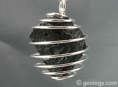
In a rare find, researchers have identified the first known tektite field in South America. The field stretches over 900 kilometers through several states in Brazil. Tektites are a type of impactite created by the intense heat of an asteroid impact. The image above shows a pendant made with a tektite from the Indochina strewn field.
EOS
In a rare find, researchers have identified the first known tektite field in South America. The field stretches over 900 kilometers through several states in Brazil. Tektites are a type of impactite created by the intense heat of an asteroid impact. The image above shows a pendant made with a tektite from the Indochina strewn field.
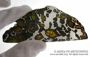
Gems from Space
Geology.com
Meteorites and impactites are sometimes used to create unique jewelry items. The image above, we see two gems that were faceted from pieces of moldavite, which is a natural glass that is thought to have formed from an ancient asteroid impact.
Geology.com
Meteorites and impactites are sometimes used to create unique jewelry items. The image above, we see two gems that were faceted from pieces of moldavite, which is a natural glass that is thought to have formed from an ancient asteroid impact.
Suspected Meteorite Hits Houston-Area Home
KPRC 2 Click2Houston on YouTube
A woman who lives near Houston, Texas was surprised to find that a suspected meteorite had crashed through the roof of her home on March 21. In this video, the homeowner, Sherrie James, recounts the incident.
KPRC 2 Click2Houston on YouTube
A woman who lives near Houston, Texas was surprised to find that a suspected meteorite had crashed through the roof of her home on March 21. In this video, the homeowner, Sherrie James, recounts the incident.
How Much Are Meteorites Worth?
Geoffrey Notkin's Meteorwritings
A 67.9-gram half slice of the Imilac pallasite from Chile's Atacama Desert. This meteorite has been sectioned and polished to reveal beautiful translucent olivine crystals. Pallasites are believed to have formed at the core/mantle boundary of large asteroids and are among the most sought after of meteorite collectibles. Imilac is a particularly stable pallasite and examples such as this one, with clear and colorful crystals, are highly prized by collectors and can sell for over $40/gram. Photograph by Leigh Anne DelRay, copyright Aerolite Meteorites.
Tropical Cyclone Narelle Crosses Australia
NASA Earth Observatory
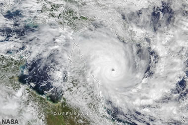
The NASA satellite image above shows Tropical Cyclone Narelle approaching the Cape York Peninsula in Queensland on March 20. NASA Earth Observatory images by Michala Garrison, using VIIRS data from NASA EOSDIS LANCE, GIBS/Worldview, and the Joint Polar Satellite System (JPSS).
NASA Earth Observatory
The NASA satellite image above shows Tropical Cyclone Narelle approaching the Cape York Peninsula in Queensland on March 20. NASA Earth Observatory images by Michala Garrison, using VIIRS data from NASA EOSDIS LANCE, GIBS/Worldview, and the Joint Polar Satellite System (JPSS).
Life's Genetic Code Has 5 Key Ingredients. Asteroid Ryugu Has All of Them
Smithsonian Magazine
From the article: "The findings further hint that space rocks may have brought the building blocks of RNA and DNA to Earth long ago". Image by Kevin M. Gill, JAXA, displayed here under a Creative Commons License.
Smithsonian Magazine
From the article: "The findings further hint that space rocks may have brought the building blocks of RNA and DNA to Earth long ago". Image by Kevin M. Gill, JAXA, displayed here under a Creative Commons License.
.png)
Watch the Meteor that Shook Cleveland and Soared Over 6+ States
The Weather Channel
Blue sky dashcam videos of the meteor streaking over Ohio and neighboring states. When it exploded in the atmosphere, the noise and the body sensation produced by the pressure wave gave some people the fright of their life. Plus, see what a meteor looks like on a still Doppler radar image.
Pompeii Plaster Casts on Display in a New Museum Exhibition
Smithsonian Magazine
From the article: "The casts preserve residents' final moments before the eruption covered Pompeii in thick layers of ash and volcanic debris, freezing the ancient city in time."
Smithsonian Magazine
From the article: "The casts preserve residents' final moments before the eruption covered Pompeii in thick layers of ash and volcanic debris, freezing the ancient city in time."
Mount Vesuvius: The Volcano that Buried Pompeii
Geology.com
Plaster casts of people who died in the city of Pompeii during the 79 AD eruption of Mount Vesuvius. They were buried in volcanic ash. Image: Garden of the Fugitives. This photo was taken by Lancevortex and is distributed under a GNU Free Documentation License.
Geology.com
Plaster casts of people who died in the city of Pompeii during the 79 AD eruption of Mount Vesuvius. They were buried in volcanic ash. Image: Garden of the Fugitives. This photo was taken by Lancevortex and is distributed under a GNU Free Documentation License.
Mount Vesuvius: All About the Volcano
Geology.com
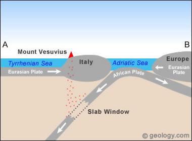
Map showing the location of Mount Vesuvius on the west coast of Italy. Other nearby volcanoes: Etna, Stromboli.
Geology.com
Map showing the location of Mount Vesuvius on the west coast of Italy. Other nearby volcanoes: Etna, Stromboli.
Lake Coatepeque Caldera
NASA Earth Observatory
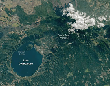
Lake Coatepeque formed during a series of explosive volcanic eruptions between 72,000 and 51,000 years ago. It is located just inland from the Pacific coast of El Salvador. This photo was captured by an astronaut onboard the International Space Station in February, 2026. The link above will take you to an article about the lake and its surrounding landscape. Additional images taken by astronauts and cosmonauts can be viewed at the NASA/JSC Gateway to Astronaut Photography of Earth. Story by Kathryn Hansen.
NASA Earth Observatory
Lake Coatepeque formed during a series of explosive volcanic eruptions between 72,000 and 51,000 years ago. It is located just inland from the Pacific coast of El Salvador. This photo was captured by an astronaut onboard the International Space Station in February, 2026. The link above will take you to an article about the lake and its surrounding landscape. Additional images taken by astronauts and cosmonauts can be viewed at the NASA/JSC Gateway to Astronaut Photography of Earth. Story by Kathryn Hansen.
What is a Caldera? How Do Calderas Form?
Geology.com
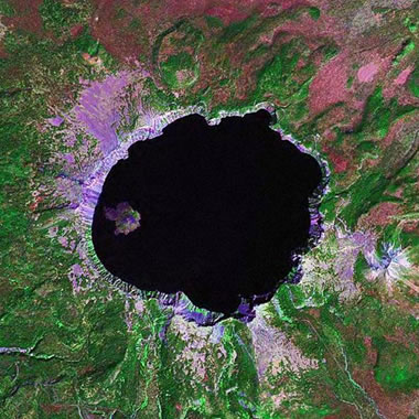
Calderas are some of the most spectacular features on Earth. They are large volcanic craters that form by two different methods: 1) an explosive volcanic eruption; or, 2) collapse of surface rock into an empty magma chamber. The image above is a satellite view of Crater Lake, one of the world's most famous calderas. The image was produced by Angela King of Geology.com using Landsat GeoCover data from NASA.
Geology.com
Calderas are some of the most spectacular features on Earth. They are large volcanic craters that form by two different methods: 1) an explosive volcanic eruption; or, 2) collapse of surface rock into an empty magma chamber. The image above is a satellite view of Crater Lake, one of the world's most famous calderas. The image was produced by Angela King of Geology.com using Landsat GeoCover data from NASA.
Ailing "Megaberg" Sparks Surge of Microscopic Life
NASA Earth Observatory
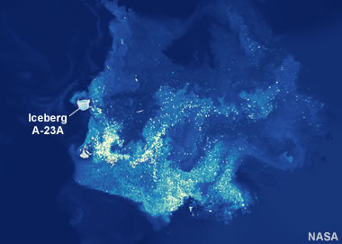
In the false-color image above, plumes of chlorophyll-a are detected in the wake of Iceberg A-23A, shown here just north of South Georgia Island. Chlorophyll concentrations are used to measure the abundance of phytoplankton in the water, and we can conclude that the nutrient-rich meltwater from the iceberg has contributed to a large phytoplankton bloom in the South Atlantic Ocean. NASA Earth Observatory images by Michala Garrison, using VIIRS data from NASA EOSDIS LANCE, GIBS/Worldview, and the Suomi National Polar-orbiting Partnership, PACE data from the NASA Ocean Biology Distributed Active Archive Center OB.DAAC, and Landsat data from the U.S. Geological Survey.
NASA Earth Observatory
In the false-color image above, plumes of chlorophyll-a are detected in the wake of Iceberg A-23A, shown here just north of South Georgia Island. Chlorophyll concentrations are used to measure the abundance of phytoplankton in the water, and we can conclude that the nutrient-rich meltwater from the iceberg has contributed to a large phytoplankton bloom in the South Atlantic Ocean. NASA Earth Observatory images by Michala Garrison, using VIIRS data from NASA EOSDIS LANCE, GIBS/Worldview, and the Suomi National Polar-orbiting Partnership, PACE data from the NASA Ocean Biology Distributed Active Archive Center OB.DAAC, and Landsat data from the U.S. Geological Survey.
Satellite Views of Phytoplankton Blooms in Oceans and Seas
Geology.com

Phytoplankton Bloom Off New Jersey: An unusual phytoplankton bloom occurred in the Atlantic Ocean off the coast of New Jersey on July 6, 2016. This bloom received nutrients from a process known as "upwelling". Strong, persistent winds, blowing off the continent and towards the east, carried surface waters away from the coast. This brought cold, nutrient-rich waters up the continental slope to replace the waters that were blown out to sea. The result was a near-shore phytoplankton bloom. Similar blooms occur periodically along the Atlantic coast in the summer. This NASA satellite image was prepared by Jeff Schmaltz.
Geology.com
Phytoplankton Bloom Off New Jersey: An unusual phytoplankton bloom occurred in the Atlantic Ocean off the coast of New Jersey on July 6, 2016. This bloom received nutrients from a process known as "upwelling". Strong, persistent winds, blowing off the continent and towards the east, carried surface waters away from the coast. This brought cold, nutrient-rich waters up the continental slope to replace the waters that were blown out to sea. The result was a near-shore phytoplankton bloom. Similar blooms occur periodically along the Atlantic coast in the summer. This NASA satellite image was prepared by Jeff Schmaltz.
Scoria Cones on Earth and Mars
NASA Earth Observatory
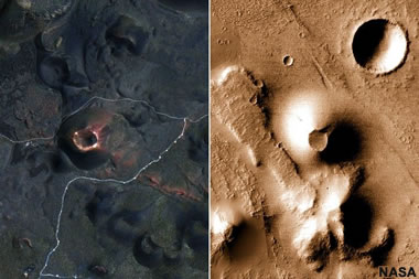
Here we see a side-by-side comparison of the San Francisco Volcanic Field in Arizona, USA, and the Ulysses Colles area in the Tharsis quadrangle of Mars. "Understanding similar features on Earth helps us know what to look for on Mars and interpret processes that we can’t observe directly," said Patrick Whelley, a NASA volcanologist. NASA Earth Observatory images by Lauren Dauphin, using Landsat data from the U.S. Geological Survey and CTX data from the Mars Reconnaissance Orbiter.
NASA Earth Observatory
Here we see a side-by-side comparison of the San Francisco Volcanic Field in Arizona, USA, and the Ulysses Colles area in the Tharsis quadrangle of Mars. "Understanding similar features on Earth helps us know what to look for on Mars and interpret processes that we can’t observe directly," said Patrick Whelley, a NASA volcanologist. NASA Earth Observatory images by Lauren Dauphin, using Landsat data from the U.S. Geological Survey and CTX data from the Mars Reconnaissance Orbiter.
What is Scoria?
Geology.com
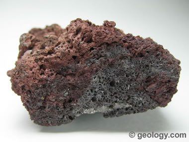
Scoria is a dark-colored, vesicular igneous rock that forms from basaltic magmas.
Geology.com
Scoria is a dark-colored, vesicular igneous rock that forms from basaltic magmas.
What is a Scoria Cone?
Geology.com

Scoria cones, also called pyroclastic cones or cinder cones, are the simplest and most common type of volcano on Earth. In the image above, Cumbre Vieja Volcano erupts cinders on Spain's Canary Island of La Palma in September 2021.
Geology.com
Scoria cones, also called pyroclastic cones or cinder cones, are the simplest and most common type of volcano on Earth. In the image above, Cumbre Vieja Volcano erupts cinders on Spain's Canary Island of La Palma in September 2021.
Birthstones for the Month of March: Aquamarine and Bloodstone
Geology.com

Aquamarine is a greenish blue to blue variety of the mineral beryl. Compared to other varieties of beryl such as emerald and red beryl, aquamarine gemstones are abundant and affordable.
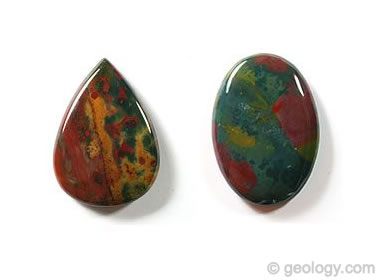
Bloodstone is a green chalcedony with splashes of red. It is sometimes referred to as "heliotrope" in books from the 18th century. It has been used as a birthstone for the month of March since 1912.
Geology.com
Aquamarine is a greenish blue to blue variety of the mineral beryl. Compared to other varieties of beryl such as emerald and red beryl, aquamarine gemstones are abundant and affordable.
Bloodstone is a green chalcedony with splashes of red. It is sometimes referred to as "heliotrope" in books from the 18th century. It has been used as a birthstone for the month of March since 1912.
Cloud Seeding: Why More Countries are Turning to Weather Modification
CNBC
The process of "cloud seeding" involves introducing tiny particles of a substance (such as silver iodide) to existing clouds in an effort to induce precipitation. According to the World Meteorological Organization, over 50 countries are experimenting with cloud seeding to alleviate drought, reduce air pollution, or simply control the weather for major events.
Chilled New York City
NASA Earth Observatory
This image shows the large chunks of ice floating in the Hudson River during an extended cold spell in late January. In this false-color image, the ice appears light blue, water appears dark blue, and vegetation appears red. NASA Earth Observatory image by Michala Garrison, using Landsat data from the U.S. Geological Survey.
Showy Swirls Around Jeju Island
NASA Earth Observatory
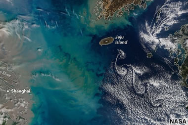
From the article: "Winds blowing past the volcanic landmass near the Korean Peninsula created a trail of spiraling clouds, while murky water churned nearby." NASA Earth Observatory image by Michala Garrison, using MODIS data from NASA EOSDIS LANCE and GIBS/Worldview. Story by Lindsey Doermann.
NASA Earth Observatory
From the article: "Winds blowing past the volcanic landmass near the Korean Peninsula created a trail of spiraling clouds, while murky water churned nearby." NASA Earth Observatory image by Michala Garrison, using MODIS data from NASA EOSDIS LANCE and GIBS/Worldview. Story by Lindsey Doermann.
The Irishman Reviving the Forgotten Sport of Stone Lifting
The Guardian
Not an Olympic Sport, but in many parts of the world people participate in an athletic (and mental) activity of lifting very heavy stones. See the Wikipedia article to learn a few of the places where it is practiced. The photo above shows a lifting stone weighing 143 kilograms that is said to have been lifted overhead by Bybon son of Phola in Greece during the early 6th century BC (Image by an unknown photographer, shown here under a Creative Commons license. Learn more at LiftingStones.org
What A Solar Superstorm Could Mean for the United States
United States Geological Survey
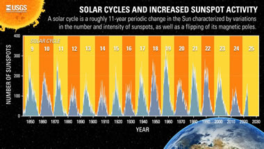
If a geomagnetic storm as large as the famed “Carrington Event” of 1859 were to occur today, it could adversely affect telecommunications and electric power transmission systems across the U.S., especially in the Midwest and the East Coast. About the image: The graphic shows the last 17 solar cycles and their related increased sunspot activity. A solar cycle is a roughly 11-year periodic change in the Sun characterized by variations in the number and intensity of sunspots, as well as a flipping of its magnetic poles.
The table shows the peaks and troughs of solar activity from when measurements began in 1850 until today. Public domain image by the United States Geological Survey.
United States Geological Survey
If a geomagnetic storm as large as the famed “Carrington Event” of 1859 were to occur today, it could adversely affect telecommunications and electric power transmission systems across the U.S., especially in the Midwest and the East Coast. About the image: The graphic shows the last 17 solar cycles and their related increased sunspot activity. A solar cycle is a roughly 11-year periodic change in the Sun characterized by variations in the number and intensity of sunspots, as well as a flipping of its magnetic poles.
The table shows the peaks and troughs of solar activity from when measurements began in 1850 until today. Public domain image by the United States Geological Survey.
Reaching Top Speed in the Dolomites
NASA
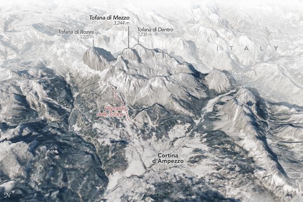
Nestled among high snowy peaks in northern Italy, the city of Cortina d'Ampezzo is hosting athletes in the 2026 Winter Olympics and Paralympics who are skiing, sliding, and curling toward a spot on the podium. The scenic mountain town is the co-host, along with Milan, of the international sporting extravaganza.
Cortina sits within the Dolomites, a mountain range in the northern Italian Alps known for its sheer cliffs, rock pinnacles, tall peaks, and deep, narrow valleys. The three-dimensional oblique map above (click the image to enlarge it), shows the city of Cortina, and to the north, several peaks over 3,000 meters (10,000 feet) tall rise above the town.
The oblique image map above was created by Michala Garrison, using Landsat data from the U.S. Geological Survey and elevation data from TINITALY. Story by Lindsey Doermann. Garrison and Doermann are on the staff of NASA Earth Observatory.
What Is Dolomite?
Geology.com
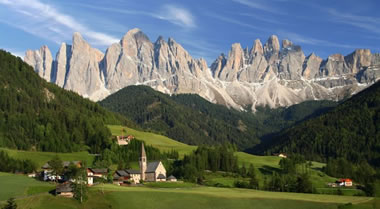
"Dolomite" is a sedimentary rock similar to limestone. It is also known as "dolostone" and "dolomite rock." The gray rocks in the mountain range above are composed mostly of dolomite.
"The Dolomites" are a mountain range in northeastern Italy and part of the Italian Alps. They are one of the largest exposures of dolomite rock on Earth - from which their name is obtained. The Dolomites are a UNESCO World Heritage Site. Image copyright iStockphoto / Dan Breckwoldt.
Geology.com
"Dolomite" is a sedimentary rock similar to limestone. It is also known as "dolostone" and "dolomite rock." The gray rocks in the mountain range above are composed mostly of dolomite.
"The Dolomites" are a mountain range in northeastern Italy and part of the Italian Alps. They are one of the largest exposures of dolomite rock on Earth - from which their name is obtained. The Dolomites are a UNESCO World Heritage Site. Image copyright iStockphoto / Dan Breckwoldt.
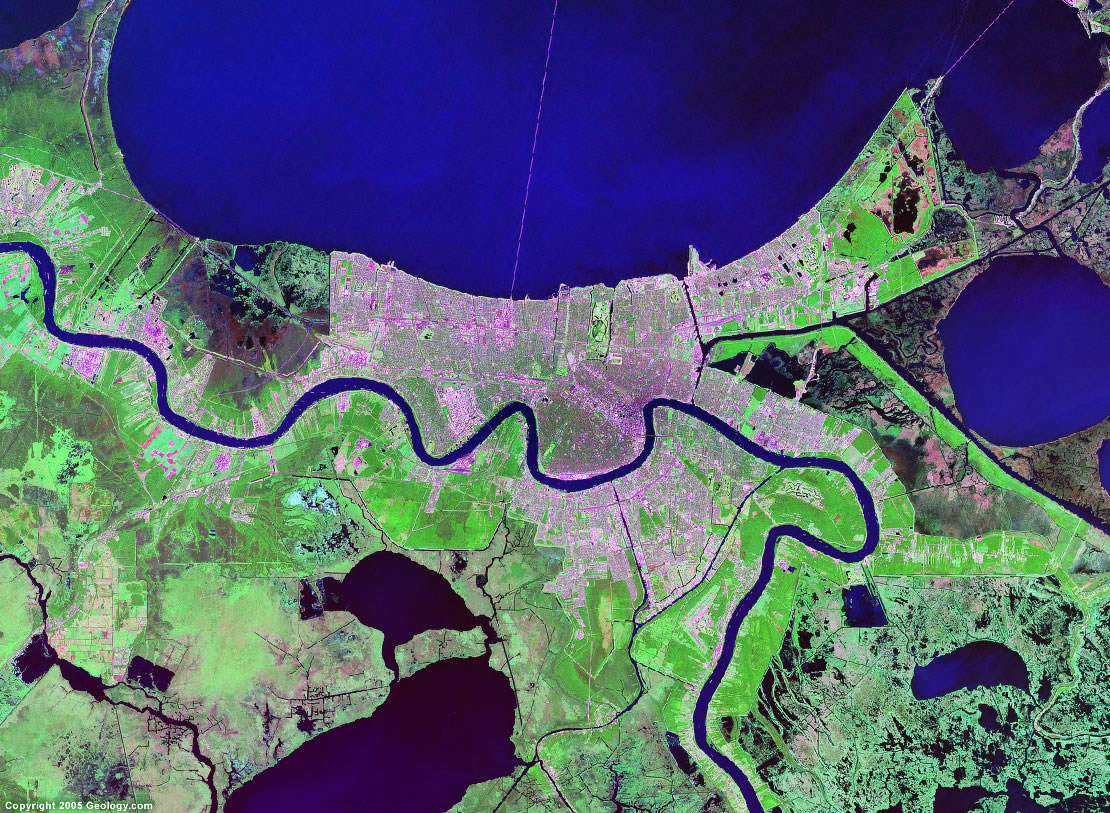
New Radar Images from the NISAR Satellite Mission -
A joint mission by NASA and the Indian Space Research Organisation
NASA
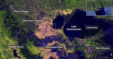
The Joint NISAR project uses a radar instrument that has the ability to "see through cloud cover". They recently produced images of the area around New Orleans, Baton Rouge, Lake Pontchartrain and surrounding wetlands. Click the image above to see a four megabyte view. Image produced by NASA and the Indian Space Research Organisation.
A joint mission by NASA and the Indian Space Research Organisation
NASA
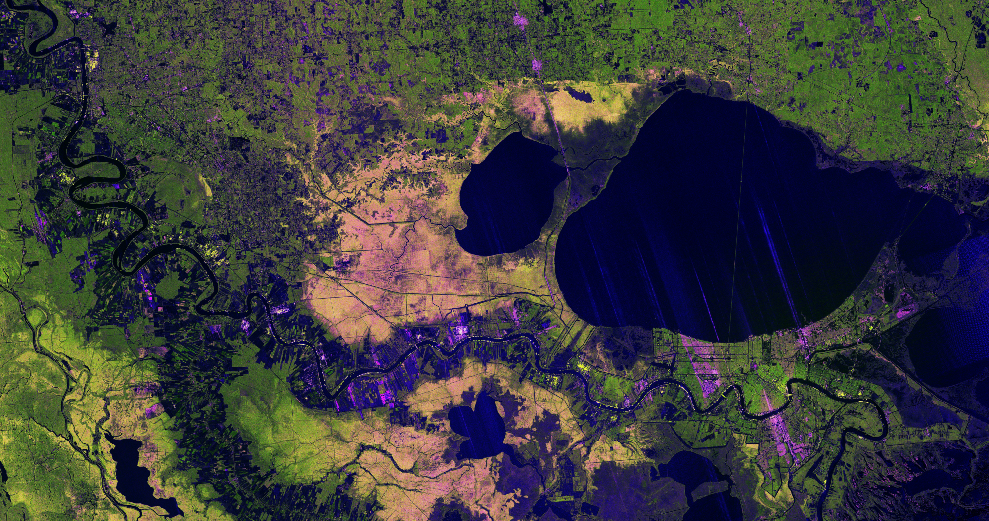
The Joint NISAR project uses a radar instrument that has the ability to "see through cloud cover". They recently produced images of the area around New Orleans, Baton Rouge, Lake Pontchartrain and surrounding wetlands. Click the image above to see a four megabyte view. Image produced by NASA and the Indian Space Research Organisation.
Successful Fund Raising Appeal Helps Buy the Land Around Cerne Abbas Giant
Bournemouth Daily Echo
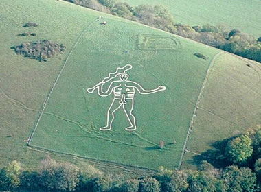
A successful fund-raising appeal helped The National Trust produce approximately £330,000 needed to help purchase the land around the Cerne Abbas Giant Sculpture near Dorset, England. This enormous artwork is thought to have been first carved in the Early Medieval Period (770-1100 AD). It is one of many similar figures carved into the chalky earth in that area. Some consider it to be a landscape-sized petroglyph. Aerial photo taken on 2001-10-07 by Pete Harlow from a Cessna 150 aircraft using a Nikon F70, AF Nikkor 35-80mm on Fujichrome Velvia. Copyright © 2001 Pete Harlow – www.catnip.co.uk This photograph is displayed here under a Creative Commons License.
Bournemouth Daily Echo
A successful fund-raising appeal helped The National Trust produce approximately £330,000 needed to help purchase the land around the Cerne Abbas Giant Sculpture near Dorset, England. This enormous artwork is thought to have been first carved in the Early Medieval Period (770-1100 AD). It is one of many similar figures carved into the chalky earth in that area. Some consider it to be a landscape-sized petroglyph. Aerial photo taken on 2001-10-07 by Pete Harlow from a Cessna 150 aircraft using a Nikon F70, AF Nikkor 35-80mm on Fujichrome Velvia. Copyright © 2001 Pete Harlow – www.catnip.co.uk This photograph is displayed here under a Creative Commons License.
Types of Rock Art: Petroglyphs and Pictographs
Geology.com
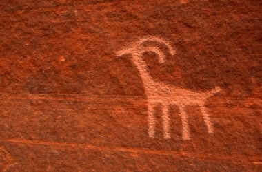
A petroglyph is an image that is carved into a rock. This "carving" can produce a visible indentation in the rock, or it can simply be the scratching away of a weathered surface to reveal unweathered material of a different color below. Image copyright iStockphoto / amygdala_imagery.
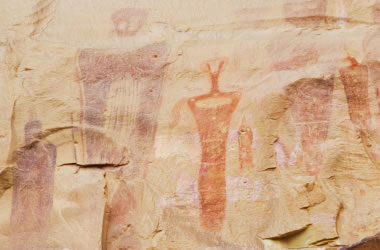
A pictograph is a drawing or painting that is created on a rock. It is not "carved" into the rock. Image copyright iStockphoto / Andrea Gingerich.
Geology.com
A petroglyph is an image that is carved into a rock. This "carving" can produce a visible indentation in the rock, or it can simply be the scratching away of a weathered surface to reveal unweathered material of a different color below. Image copyright iStockphoto / amygdala_imagery.
A pictograph is a drawing or painting that is created on a rock. It is not "carved" into the rock. Image copyright iStockphoto / Andrea Gingerich.
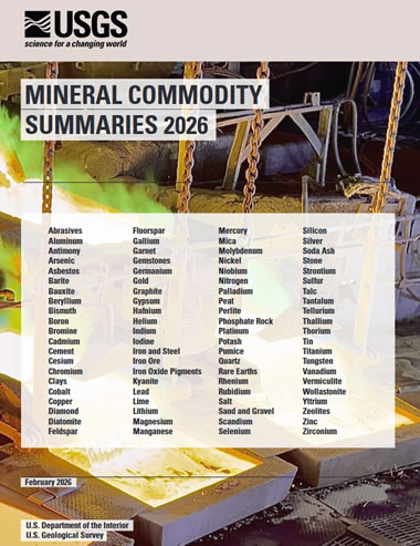
USGS Releases Its Annual Mineral Commodity Summaries for 2026
United States Geological Survey
This publication is the first and most authoritative source for mineral production, trade and consumption data. Published by the United States Geological Survey; you can get a PDF online here.
United States Geological Survey
This publication is the first and most authoritative source for mineral production, trade and consumption data. Published by the United States Geological Survey; you can get a PDF online here.
Nevada, Arizona and Texas Are the Top U.S. Mineral Producers for 2025
United States Geological Survey
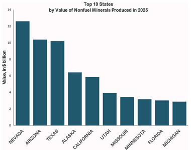
The graph above shows the ten U.S. states with the highest dollar value of non-fuel mineral production. See page 14 and 15 in the Mineral Commodity Summary for a list of the top mineral commodities for each state. Top commodities for Nevada, Arizona and Texas are listed below.
United States Geological Survey
The graph above shows the ten U.S. states with the highest dollar value of non-fuel mineral production. See page 14 and 15 in the Mineral Commodity Summary for a list of the top mineral commodities for each state. Top commodities for Nevada, Arizona and Texas are listed below.
Nevada
produced $12.6 billion dollars worth of copper, diatomite, gold, sand and gravel, silver, and other commodities.Arizona
produced $10.4 billion dollars worth of cement, copper, molybdenum mineral concentrates, sand and gravel, crushed stone, and other commodities.Texas
produced $10.2 billion dollars worth of cement, lime, sand and gravel, industrial sand, and crushed stone.Diatomite: The Rock Used to Make Beer
Geology.com

Diatomite is a rock composed of the siliceous skeletal remains of diatoms. It has a very small particle size, a high porosity, and is relatively inert. That makes it an excellent material for use as a filter. Much of the beer brewed in the United States is filtered through crushed diatomite, known as diatomaceous earth.
Geology.com
Diatomite is a rock composed of the siliceous skeletal remains of diatoms. It has a very small particle size, a high porosity, and is relatively inert. That makes it an excellent material for use as a filter. Much of the beer brewed in the United States is filtered through crushed diatomite, known as diatomaceous earth.
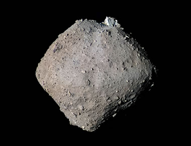
An Asteroid Might Slam Into the Moon in 2032
and Create a Fiery Flash That’s Visible to Earthlings
Smithsonian Magazine
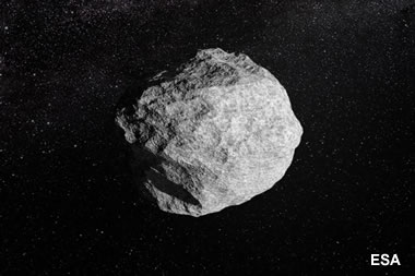
From the article: "Currently, NASA estimates that asteroid 2024 YR4 has a 4.3 percent chance of hitting our lunar companion." The image is an artist's creation of an asteroid - by the European Space Agency Science Office.
and Create a Fiery Flash That’s Visible to Earthlings
Smithsonian Magazine
From the article: "Currently, NASA estimates that asteroid 2024 YR4 has a 4.3 percent chance of hitting our lunar companion." The image is an artist's creation of an asteroid - by the European Space Agency Science Office.
New Earthquake Model Goes Against the Grain
EOS
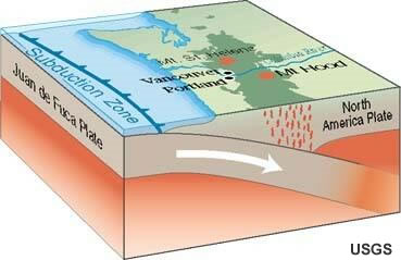
From the article: "Subducting plates are stronger in certain directions than in others, which may be a factor in how earthquakes occur and how seismic waves propagate." Subduction zone image by the United States Geological Survey.
EOS
From the article: "Subducting plates are stronger in certain directions than in others, which may be a factor in how earthquakes occur and how seismic waves propagate." Subduction zone image by the United States Geological Survey.
Record Natural Gas Withdrawals During the Week Ending January 30, 2026
Energy Information Administration
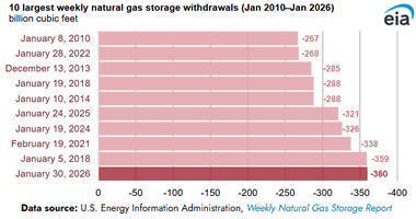
Working natural gas stocks fell 360 billion cubic feet (Bcf) in the Lower 48 states for the week ending January 30, 2026, amid Winter Storm Fern -- the largest weekly net withdrawal reported in the history of the Weekly Natural Gas Storage Report. The withdrawal exceeded the five-year average for the same week by 89% (170 Bcf). The large withdrawals resulted from increased heating demand for natural gas and natural gas production curtailments because of severe winter weather.
Energy Information Administration
Working natural gas stocks fell 360 billion cubic feet (Bcf) in the Lower 48 states for the week ending January 30, 2026, amid Winter Storm Fern -- the largest weekly net withdrawal reported in the history of the Weekly Natural Gas Storage Report. The withdrawal exceeded the five-year average for the same week by 89% (170 Bcf). The large withdrawals resulted from increased heating demand for natural gas and natural gas production curtailments because of severe winter weather.
The Green River Flows ‘Uphill.’ Geologists Think They Finally Know Why.
Popular Science
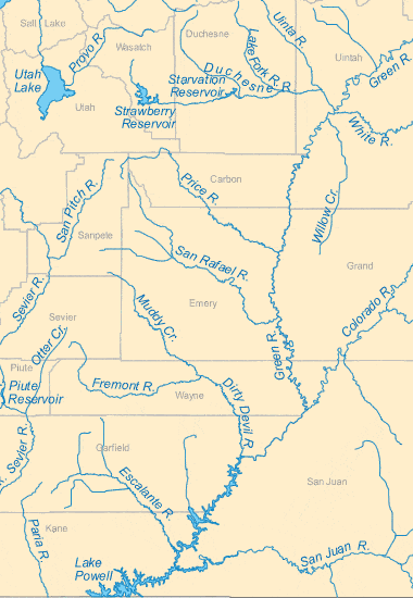
From the article: "An international research team now believes they can explain this longtime mystery behind one of North America’s most prominent river systems. Map shows the confluence of the Green and Colorado Rivers in southeastern Utah. Map by Geology.com.
Popular Science
From the article: "An international research team now believes they can explain this longtime mystery behind one of North America’s most prominent river systems. Map shows the confluence of the Green and Colorado Rivers in southeastern Utah. Map by Geology.com.
Fossils of the Green River Formation
Geology.com
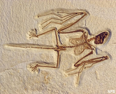
Spectacular fish, animal, plant, insect, and other fossils have been found in the rocks of the Green River Formation in Colorado, Utah and Wyoming. Shown above is a fossilized bat found in the formation. It is the most primitive bat known. Photo by the National Park Service.
Geology.com
Spectacular fish, animal, plant, insect, and other fossils have been found in the rocks of the Green River Formation in Colorado, Utah and Wyoming. Shown above is a fossilized bat found in the formation. It is the most primitive bat known. Photo by the National Park Service.
CIA Ends Publication of its Popular World Factbook Reference Tool
The Associated Press
On February 4, the CIA's website published an announcement that The World Factbook will no longer be available. The sudden termination of this important resource is a huge loss to the millions of people around the world who depend on The World Factbook for reliable maps and information, especially teachers, students, researchers, journalists, and international travelers.
When Is a Sapphire Truly a "Color Change" Sapphire?
Lotus Gemology
Some sapphires change color when exposed to varying wavelengths of light from different light sources. Trace elements in the stone such as Cr, V, or Fe often cause the stone to have different apparent colors under different wavelengths / light sources. Spectacular photo here!
Lotus Gemology
Some sapphires change color when exposed to varying wavelengths of light from different light sources. Trace elements in the stone such as Cr, V, or Fe often cause the stone to have different apparent colors under different wavelengths / light sources. Spectacular photo here!
Dinosaur National Monument Construction Work Turns Up New Fossils
Smithsonian Magazine
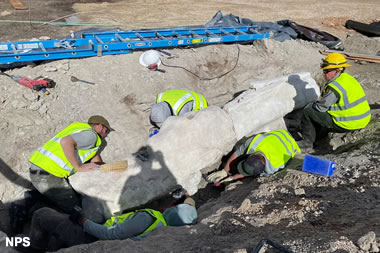
Recent digs revealed roughly 20 feet of a long-necked dinosaur’s skeleton, and paleontologists suspect even more bones are lurking underground. About the photo: "Paleontologists removed roughly 3,000 pounds of rocks and fossils from the site between mid-September and mid-October 2025." National Park Service photo, caption and article by ReBecca Hunt-Foster
Smithsonian Magazine
Recent digs revealed roughly 20 feet of a long-necked dinosaur’s skeleton, and paleontologists suspect even more bones are lurking underground. About the photo: "Paleontologists removed roughly 3,000 pounds of rocks and fossils from the site between mid-September and mid-October 2025." National Park Service photo, caption and article by ReBecca Hunt-Foster
A ‘Very Rare’ Kind of Space Rock Fell in Germany
Smithsonian Magazine
From the article: "Analyses revealed the asteroid was an “aubrite,” a classification that applies to only 80 of 70,000 previously found meteorite fragments."
Smithsonian Magazine
From the article: "Analyses revealed the asteroid was an “aubrite,” a classification that applies to only 80 of 70,000 previously found meteorite fragments."
Cracking Antarctic Sea Ice
NASA Earth Observatory
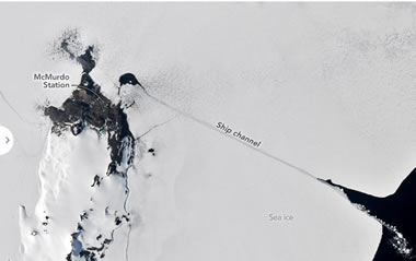
Icebreakers play a critical role in delivering supplies to America's largest research base in Antarctica. In the austral summer, usually in January, an icebreaker rams a path through the fast ice—a type of sea ice that is anchored to the shore—that often covers McMurdo Sound. This annual effort allows cargo ships to reach McMurdo Station, a research base operated by the United States Antarctic Program.
Where Is This Place?
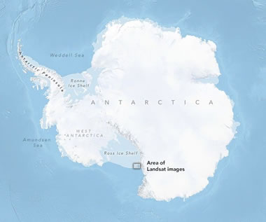
NASA Earth Observatory
Icebreakers play a critical role in delivering supplies to America's largest research base in Antarctica. In the austral summer, usually in January, an icebreaker rams a path through the fast ice—a type of sea ice that is anchored to the shore—that often covers McMurdo Sound. This annual effort allows cargo ships to reach McMurdo Station, a research base operated by the United States Antarctic Program.
Where Is This Place?
Amethyst: Birthstone for February
Geology.com
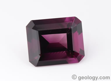
Amethyst is the purple color variety of quartz. Because it is widely available and inexpensive, amethyst is the world's most popular purple gemstone.
Geology.com
Amethyst is the purple color variety of quartz. Because it is widely available and inexpensive, amethyst is the world's most popular purple gemstone.
Watch the Geographic Fluctuation of Air Temperature for January 21st through January 29th
NOAA
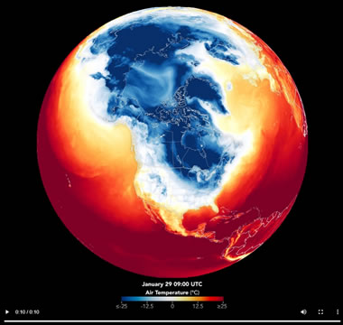
For more information visit NOAA's Extreme January Cold. Following a significant winter storm, frigid temperatures lingered in late January 2026 across a vast swath of the U.S. Watch the cold progress into the Gulf states. Animation by NOAA.
NOAA
For more information visit NOAA's Extreme January Cold. Following a significant winter storm, frigid temperatures lingered in late January 2026 across a vast swath of the U.S. Watch the cold progress into the Gulf states. Animation by NOAA.
As Seas Rise, Corals Can’t Keep Up
EOS

Coral reefs are not growing fast enough to keep up with sea level rise. Photograph of Acropora spp by Jonathan Brown, NOAA Fisheries.
EOS
Coral reefs are not growing fast enough to keep up with sea level rise. Photograph of Acropora spp by Jonathan Brown, NOAA Fisheries.
Jinxiuite: A New Nickel Bismuth Antimony Arsenic Sulfide Mineral Discovered in China
MinDat.org
Geologists from the Chinese Academy of Geological Sciences discovered a new nickel bismuth antimony arsenic sulfide mineral named Jinxiuite at the Longhua Ni-Co deposit, Xiangzhou County, Laibin, Guangxi, China. The mineral has an extraordinary chemical composition of Ni18Bi2SbAsS16.
MinDat.org
Geologists from the Chinese Academy of Geological Sciences discovered a new nickel bismuth antimony arsenic sulfide mineral named Jinxiuite at the Longhua Ni-Co deposit, Xiangzhou County, Laibin, Guangxi, China. The mineral has an extraordinary chemical composition of Ni18Bi2SbAsS16.
World's Deepest Seismometer Braces the South Pole!
United States Geological Survey
Get ready to journey to the bottom of the world! The Deep Ice Seismometer is a groundbreaking new tool that will revolutionize how we monitor earthquakes across the globe. Why Antarctica? Because it offers the perfect conditions to eliminate noise and distortion, allowing the seismometer to detect even the faintest vibrations from anywhere on Earth.
Silver Hits $100/ounce, as Gold Nears $5,000/ounce
JCK Online
Two milestones: on Friday, January 23rd, silver broke $100/ounce and gold was only $14 short of $5,000/ounce. These prices are surpassing what almost anyone expected one year ago. Where will these rockets stop?
JCK Online
Two milestones: on Friday, January 23rd, silver broke $100/ounce and gold was only $14 short of $5,000/ounce. These prices are surpassing what almost anyone expected one year ago. Where will these rockets stop?
Lab-Grown Diamonds Are Destroying Economies. Is That Okay?
JCK Online
Botswana, a country in Africa and a leading producer of natural diamonds, is in economic collapse. Their diamond revenues are declining as more diamond shoppers elect to purchase lab-grown diamonds instead of natural diamonds produced from a mine.
JCK Online
Botswana, a country in Africa and a leading producer of natural diamonds, is in economic collapse. Their diamond revenues are declining as more diamond shoppers elect to purchase lab-grown diamonds instead of natural diamonds produced from a mine.
Which Countries Mine the Most Gem-Quality Diamonds?
Geology.com
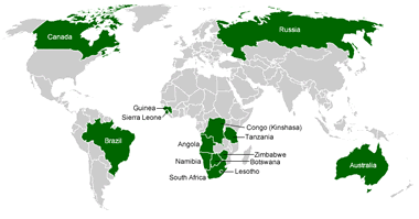
Once centered in Africa, diamond mining now occurs in many countries throughout the world. In recent years, Russia, Canada, and Botswana have been leading producers of mined diamonds.
Geology.com
Once centered in Africa, diamond mining now occurs in many countries throughout the world. In recent years, Russia, Canada, and Botswana have been leading producers of mined diamonds.
"Repatriate the Gold": Economists Advise Withdrawal From U.S. Vaults
The Guardian
Many German economists, politicians, and government officials are calling for the 1,236 tonnes of German government gold being stored in the United States to be brought home to Germany. Why ?? They don't trust the political environment of the United States. The United States and Germany are the two countries with the world's highest gold reserves.
The Many Uses of Gold
Geology.com
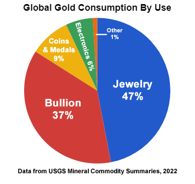
The United States government currently mints coins from gold and other precious metals; however, they are intended for investment and collecting. They are not intended for use as legal tender.
Geology.com
The United States government currently mints coins from gold and other precious metals; however, they are intended for investment and collecting. They are not intended for use as legal tender.
WARNINGS From the National Weather Service: Staying Safe in Extreme Cold
National Weather Service
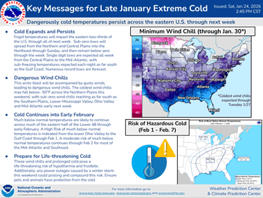
Guidance on dealing with extremely cold weather from the National Weather Service. Please check it out !!
National Weather Service
Guidance on dealing with extremely cold weather from the National Weather Service. Please check it out !!
U.S. Natural Gas Prices Spike in January - WOW !!
U.S. Energy Information Administration
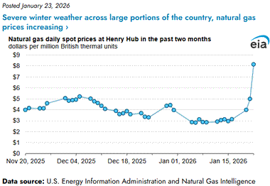
U.S. natural gas prices spiked to nearly $8.15 per million BTU on January 22, 2026 at Henry Hub as severe cold weather across much of the United States caused an enormous spike in demand. Higher natural gas prices generally translate into higher electricity prices - your electric bill that includes the last two weeks of January 2026 might shock you !
U.S. Energy Information Administration
U.S. natural gas prices spiked to nearly $8.15 per million BTU on January 22, 2026 at Henry Hub as severe cold weather across much of the United States caused an enormous spike in demand. Higher natural gas prices generally translate into higher electricity prices - your electric bill that includes the last two weeks of January 2026 might shock you !
Blooming Seas Around the Chatham Islands
NASA Earth Observatory
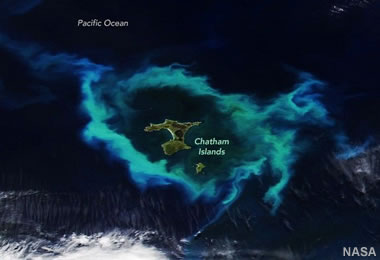
The Chatham Islands are a remote archipelago of islands located about 500 miles east of New Zealand. Phytoplankton blooms are common here because the islands sit atop an underwater plateau called the Chatham Rise, where warm subtropical water mixes with cold, nutrient-rich Antarctic currents. With the summer sunshine facilitating photosynthesis, it is a great environment for phytoplankton to thrive. NASA Earth Observatory image by Lauren Dauphin, using VIIRS data from NASA EOSDIS LANCE, GIBS/Worldview, and the Joint Polar Satellite System (JPSS).
NASA Earth Observatory
The Chatham Islands are a remote archipelago of islands located about 500 miles east of New Zealand. Phytoplankton blooms are common here because the islands sit atop an underwater plateau called the Chatham Rise, where warm subtropical water mixes with cold, nutrient-rich Antarctic currents. With the summer sunshine facilitating photosynthesis, it is a great environment for phytoplankton to thrive. NASA Earth Observatory image by Lauren Dauphin, using VIIRS data from NASA EOSDIS LANCE, GIBS/Worldview, and the Joint Polar Satellite System (JPSS).
Satellite Views of Phytoplankton Blooms in Oceans and Seas
Geology.com
Phytoplankton Bloom Off New Jersey: An unusual phytoplankton bloom occurred in the Atlantic Ocean off the coast of New Jersey on July 6, 2016. This bloom received nutrients from a process known as "upwelling". Strong, persistent winds, blowing off the continent and towards the east, carried surface waters away from the coast. This brought cold, nutrient-rich waters up the continental slope to replace the waters that were blown out to sea. The result was a near-shore phytoplankton bloom. Similar blooms occur periodically along the Atlantic coast in the summer. This NASA satellite image was prepared by Jeff Schmaltz.
Astronomers Find a New Type of Celestial Object
Smithsonian Magazine
From the article: "Named 'Cloud-9,' the discovery is a new type of celestial object known as a RELHIC, that is unlike anything scientists have ever observed." The gas-rich cloud, which is akin to a galaxy without stars, could help astronomers unravel the mysteries of dark matter.
Why Do So Many Mudflows Occur in California?
Associated Press
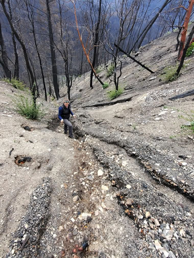
Start with steep slopes covered by hydrophobic soils, denude them of vegetation with a wildfire, and follow up with torrential rains. There you have it! USGS photographer Matt Thomas shot this interesting photo after a wildfire burned through an area near Eagle Rock, California. The land is incredibly steep, there's almost no vegetation to hold the soil in place, and the surface is covered by easily-eroded debris... The perfect recipe for a mudflow.
Associated Press
Start with steep slopes covered by hydrophobic soils, denude them of vegetation with a wildfire, and follow up with torrential rains. There you have it! USGS photographer Matt Thomas shot this interesting photo after a wildfire burned through an area near Eagle Rock, California. The land is incredibly steep, there's almost no vegetation to hold the soil in place, and the surface is covered by easily-eroded debris... The perfect recipe for a mudflow.
Nature Picks the Best Science Images of 2025
Nature
Spectacular copyrighted images of science topics ranging from Villarrica Volcano, to a lab-grown human kidney, to emerald green algae spheres, to red lightning, to a solar-powered slug, and many other subjects that are as colorful as they are interesting.
Nature
Spectacular copyrighted images of science topics ranging from Villarrica Volcano, to a lab-grown human kidney, to emerald green algae spheres, to red lightning, to a solar-powered slug, and many other subjects that are as colorful as they are interesting.
Lessons and Lingering Questions from Collapsing Basaltic Calderas
EOS
From the article: "Research into the hazardous collapses of basaltic volcanoes has revealed common physical processes, but addressing remaining questions requires learning more from historical events."
EOS
From the article: "Research into the hazardous collapses of basaltic volcanoes has revealed common physical processes, but addressing remaining questions requires learning more from historical events."
Amid the Arctic’s Hottest Year, Arctic Science Faces a Data Deficiency
EOS
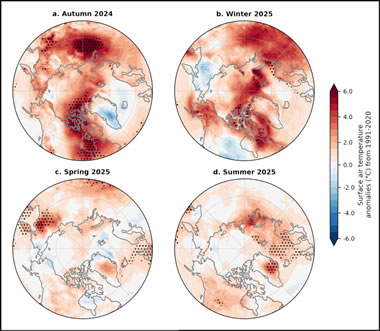
From the article: "The 20th annual Arctic Report Card reveals new highs in temperature and new lows in sea ice, as well as an uncertain outlook for the availability of federal data." The image above shows seasonal surface air temperature anomalies (in °C) for (a) autumn 2024, (b) winter 2025, (c) spring 2025, and (d) summer 2025. Image by NOAA.
EOS
From the article: "The 20th annual Arctic Report Card reveals new highs in temperature and new lows in sea ice, as well as an uncertain outlook for the availability of federal data." The image above shows seasonal surface air temperature anomalies (in °C) for (a) autumn 2024, (b) winter 2025, (c) spring 2025, and (d) summer 2025. Image by NOAA.
USGS Releases Assessment of Undiscovered Oil and Gas in the Woodford and Barnett Shales
United States Geological Survey
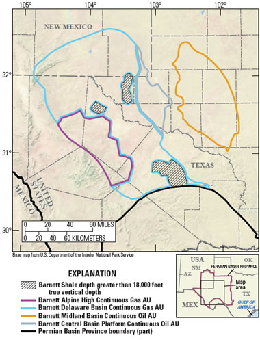
The USGS Energy Resources Program is assessing the potential undiscovered oil and gas resources in Texas and New Mexico. Two methodologies are used: one assesses conventional oil and gas resources, and one assesses unconventional (continuous) oil and gas resources (such as shale gas and coalbed gas). Map by USGS.
United States Geological Survey
The USGS Energy Resources Program is assessing the potential undiscovered oil and gas resources in Texas and New Mexico. Two methodologies are used: one assesses conventional oil and gas resources, and one assesses unconventional (continuous) oil and gas resources (such as shale gas and coalbed gas). Map by USGS.
NASA's Voyager Just Exited the Solar System -- and Found Something Wild
NASA Space News on YouTube
From the video caption: "NASA's Voyager spacecraft crossed the heliopause — the boundary where the Sun's influence ends and interstellar space begins. New data reveal that this region is far more structured and energetic than scientists expected, changing how we understand the true edge of the Solar System."
Petra Diamonds Discovers a 41.82 Carat Blue Diamond
JCK Online
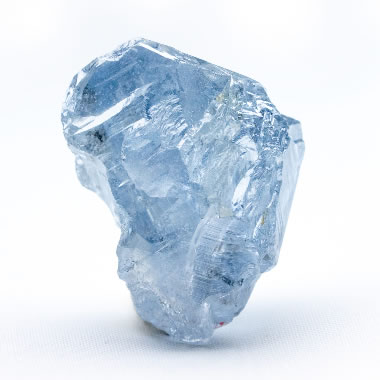
Petra Diamonds has discovered a 41.82-carat blue diamond at its famous Cullinan mine in South Africa. They say it is one of the most important blue diamonds ever found. The image is a photograph of the diamond shared by Petra Diamonds.
JCK Online
Petra Diamonds has discovered a 41.82-carat blue diamond at its famous Cullinan mine in South Africa. They say it is one of the most important blue diamonds ever found. The image is a photograph of the diamond shared by Petra Diamonds.
The Cause of Color in Blue Diamonds
Geology.com
Boron Substitution in Diamond: When boron atoms substitute for carbon atoms in the diamond crystal lattice, it causes the diamond to selectively absorb red wavelengths of light and selectively transmit blue. The blue wavelengths are what reach the eye of the observer. Illustration modified after a Creative Commons image by Materialscientist.
Freedom from China? The Mine at the Centre of Europe’s Push for Rare Earth Metals
The Guardian
From the article: "Swedish producer is trying to accelerate the process of extracting the elements vital for hi-tech products." Image: The Rare Earth Periodic Table: The Rare Earth Elements are the 15 lanthanide series elements, plus yttrium. Scandium is found in most rare earth element deposits and is sometimes classified as a rare earth element. Image by Geology.com.
Rare Earth Element Production is Up... China Is Still the Big Producer
Geology.com

This chart shows a history of rare earth element production, in metric tons of rare earth oxide equivalent, between 1950 and 2024. It clearly shows the United States' entry into the market in the mid-1960s when color television exploded demand. When China began selling rare earths at very low prices in the late 1980s and early 1990s, mines in the United States were forced to close because... read the full caption and article.
Geology.com
This chart shows a history of rare earth element production, in metric tons of rare earth oxide equivalent, between 1950 and 2024. It clearly shows the United States' entry into the market in the mid-1960s when color television exploded demand. When China began selling rare earths at very low prices in the late 1980s and early 1990s, mines in the United States were forced to close because... read the full caption and article.
15 Awesome Images From One of the World’s Most Impressive Aerial Photographers
Smithsonian Magazine
From the article: "From the cockpit of his plane, photographer Jassen Todorov’s eagle eye captures memorable landscapes"
Smithsonian Magazine
From the article: "From the cockpit of his plane, photographer Jassen Todorov’s eagle eye captures memorable landscapes"
January Birthstone: Garnet, A Mineral (and Gemstone) of Many Colors
Geology.com

Gem Garnets: When most people think of garnet, they think of a red gemstone. However, garnet is a mineral which occurs in a wide variety of colors. Clockwise from the top left: red almandine (Madagascar), green tsavorite (Tanzania), yellow mali (Mali), orange spessartite (Mozambique), pink malaya (Tanzania), green merelani mint (Tanzania), red pyrope (Cote d'Ivoire), green demantoid (Namibia), purple rhodolite (Mozambique), and orange hessonite (Sri Lanka).
Geology.com
Gem Garnets: When most people think of garnet, they think of a red gemstone. However, garnet is a mineral which occurs in a wide variety of colors. Clockwise from the top left: red almandine (Madagascar), green tsavorite (Tanzania), yellow mali (Mali), orange spessartite (Mozambique), pink malaya (Tanzania), green merelani mint (Tanzania), red pyrope (Cote d'Ivoire), green demantoid (Namibia), purple rhodolite (Mozambique), and orange hessonite (Sri Lanka).
25 Years of Chocolate Diamonds: Le Vian Marks a Jewelry Milestone
JCK Online
The name "Chocolate Diamonds®" is a registered trademark of Le Vian, a family-owned jewelry company with a long history dating back to the 15th century. In the early 2000s, Le Vian started using the name Chocolate Diamonds® for diamonds that graded to a limited range of brown hues - carefully chosen to register "chocolate" in a shopper's eye. The name was descriptive, fun, and became very popular. It elevated common brown diamonds to a new and special plane of desirability. Take a look at the diamonds shown in this article and see for yourself.
Maduro's Capture in Oil-Rich Venezuela Will Not Drop U.S. Gasoline Prices Any Time Soon
CNBC Oil and Gas
Although the United States says it is going to take over Venezuela's oil and gas industry, imports from Venezuela into the U.S. will not lower U.S. gasoline prices right away. Why? 1) Venezuela currently produces less than a million barrels per day, 2) the country's oil & gas infrastructure is in terrible condition, and, 3) ramping up production will take years.
A Siberian Snowman in Billings (Siberia)
NASA Earth Observatory

Icons of winter are sometimes found in unexpected places. In one striking example, a series of oval lagoons in a remote part of Siberia forms the shape of a towering snowman when viewed from above. NASA Earth Observatory image by Michala Garrison, using Landsat data from USGS. Story by Adam Voiland.
NASA Earth Observatory
Icons of winter are sometimes found in unexpected places. In one striking example, a series of oval lagoons in a remote part of Siberia forms the shape of a towering snowman when viewed from above. NASA Earth Observatory image by Michala Garrison, using Landsat data from USGS. Story by Adam Voiland.
Lake Eyre Blushes
NASA Earth Observatory

Rounding out a remarkable year, the outback lake displayed distinct green and reddish water in its two main bays. NASA Earth Observatory image by Lauren Dauphin, using Landsat data from USGS. Story by Lindsey Doermann.
NASA Earth Observatory
Rounding out a remarkable year, the outback lake displayed distinct green and reddish water in its two main bays. NASA Earth Observatory image by Lauren Dauphin, using Landsat data from USGS. Story by Lindsey Doermann.
Don’t Miss These Ten Celestial Events in 2026, From Aligned Planets to a Total Solar Eclipse
Smithsonian Magazine

Mark your 2026 Calendar to make sure that you don't miss your favorite events. The "progression of a solar eclipse" image displayed above is a public domain image created by Keegan Barber of NASA.


Get free printable calendars, graph paper, targets and outline maps at our WaterproofPaper.com website.
Smithsonian Magazine
Mark your 2026 Calendar to make sure that you don't miss your favorite events. The "progression of a solar eclipse" image displayed above is a public domain image created by Keegan Barber of NASA.
Get free printable calendars, graph paper, targets and outline maps at our WaterproofPaper.com website.
USGS National Water Dashboard ** Highly Recommended **
United States Geological Survey

The USGS National Water Dashboard is an interactive U.S. map with lots of useful water and weather data. You can find real-time stream gage data, current and forecasted weather and hazard conditions, alerts for flooding, fire, air quality, and more. The base map is customizable to show topographic information, roads and streets, or satellite imagery. Check it out!
United States Geological Survey
The USGS National Water Dashboard is an interactive U.S. map with lots of useful water and weather data. You can find real-time stream gage data, current and forecasted weather and hazard conditions, alerts for flooding, fire, air quality, and more. The base map is customizable to show topographic information, roads and streets, or satellite imagery. Check it out!