What Is An Archipelago?
A closely scattered cluster of islands.
Article by: Hobart M. King, PhD
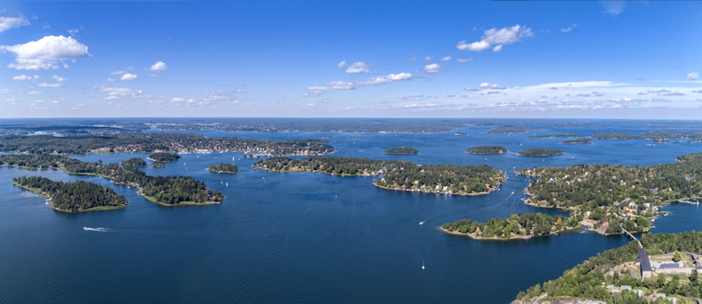
Stockholm Archipelago: With over 30,000 islands and islets, the Stockholm Archipelago is one of the world's largest. It is located along the Baltic coast of Sweden, and the city of Stockholm stretches across 14 of the islands. Over two million people live on the islands, but many of the islands are remote or tiny and uninhabited. Image copyright by Remus Kotsell / iStockphoto.
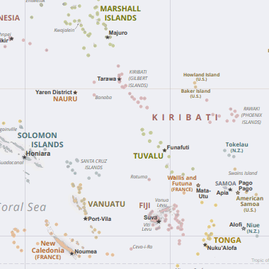
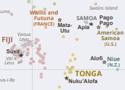
Pacific Archipelagos: There are dozens of archipelagos in the Pacific Ocean. The map above shows several archipelagos in the western Pacific. They include: Fiji, Gilbert Islands, Marshall Islands, New Caledonia, Phoenix Islands, Solomon Islands, Tokelau, Tonga, Tuvalu, and Vanuatu. Image is from the Map of Oceania, published by the United States Central Intelligence Agency.
What Is An Archipelago?
The name "archipelago" is often used when referring to a closely scattered cluster of islands. The islands of an archipelago can be in a cluster, in a chain, or scattered irregularly.
The islands of an archipelago can be in an ocean, a lake, a river, or any other body of water. A body of water that contains many closely scattered islands can also be called an "archipelago".
The Hawaiian islands, the Aleutian Islands, the Florida Keys, Bermuda, The Bahamas, the Philippines, the Canary Islands, Indonesia, and islands in the Aegean Sea are all examples of archipelagos.
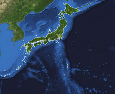
Archipelago Produced by Seafloor Volcanism: The islands of Japan (islands outlined in white) are an example of an archipelago produced by seafloor volcanism. Japan consists of four large islands, Hokkaido, Honshu, Shikoku and Kyushu, with 6848 smaller islands either clustered around them or extending from them in chains and island arcs. It is an example of an archipelago that defines a country. Volcanic activity occasionally adds a new island to the archipelago. The map above was produced by NASA.
How Do Archipelagos Form?
Archipelagos have been formed by seafloor volcanism, sea level rise or fall, coral reefs, and occasionally by the actions of people. Some of the methods by which these archipelagos have formed are explained below:
Seafloor Volcanism
The archipelago formation process that is easiest to understand is seafloor volcanism. A volcano erupts on the sea floor and grows in height until it emerges from the water's surface as an island. Then other nearby volcanoes form to make an archipelago.
Examples of volcanic archipelagos include: the Japanese Islands (see accompanying image), the Hawaiian Islands, the Canary Islands, the Azores, the Aleutian Islands, the Philippines, and Indonesia.
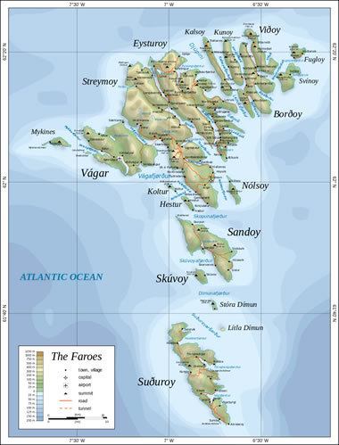
Sea Level Rise Archipelago: The Faroes are a group of islands in the North Atlantic Ocean about 200 miles (320 kilometers) north-northwest of Scotland and southeast of Iceland. The islands have a bedrock of layered basalt that was deeply glaciated during the Ice Age. Sea level rise (and isostatic subsidence) since the end of the Ice Age is flooding stream valleys, fjords, and other areas of low elevation. This has produced the 18 major islands and nearly 800 smaller islands and islets that comprise the Faroes archipelago. The map above was prepared by Oona Räisänen (Mysid), displayed here under a Creative Commons License.
Sea Level Rise
When sea level rise floods a landscape, the rising water will fill stream valleys, fjords, and other low areas. This often makes islands out of mountains, ridges, and other high areas located between the flooded valleys.
When sea level rises, it floods the lowlands and strands the highlands as islands.
The Faroe Islands are an example of an archipelago produced when an increase in sea level floods a glaciated landscape (see the accompanying image).
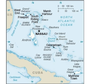
Coral Reef Archipelago: The Bahamas are an archipelago country in the Atlantic Ocean, located southeast of Florida and northeast of Cuba. The islands are composed of limestone formed from coral reef deposits and other carbonate sediments. The Bahamas archipelago and the Turks and Caicos archipelago (to the southeast), together make up the Lucayan Archipelago. Image by United States Central Intelligence Agency.
Coral Reefs
Many of today's oceanic archipelagos began as coral reefs or limestone platforms that formed in the ocean during a time of high sea level before the Ice Age. The reefs and platforms were left high and dry as water was removed from the ocean and locked into glaciers that covered much of the Earth during the Ice Age. Since the Ice Age, melting glaciers have caused global sea levels to rise, and some of those coral reefs and limestone platforms are now islands.
Examples of coral reef archipelagos include: the Florida Keys, the Bahamas, and the Turks and Caicos Islands.
The Virgin Islands archipelago contains a mix of coral islands and volcanic islands.
The Maldives are an archipelago that consists of coral atolls that were built when coral reefs colonized subsiding volcanoes.
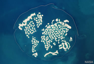
Man-Made Islands: This astronaut photograph shows how "The World," a man-made archipelago, looked in 2010. At that time, only one island had been developed for use. See our article about The Artificial Islands of Dubai). Image by NASA / ISS Expedition 22 crew. Click to enlarge.
Man-Made Archipelagos
People have built a number of archipelagos. Construction began on some of the world's largest artificial island projects in 2001, on the coast of Dubai in the United Arab Emirates. These include Palm Jumeirah, Palm Jebel Ali, Deira Islands, and The World islands (see our article about The Artificial Islands of Dubai).
The World islands project was especially interesting because it was designed to resemble a map of the world when viewed from above (see the accompanying image). These man-made island projects have only been partially completed, and some have been damaged by current and wave action. Most natural islands are only temporary features, but those built with man-made materials can be more vulnerable.
| More Maps |
 |
Gifts That Rock |
 |
Great Lakes |
 |
Map of the Oceans |
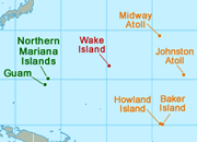 |
U.S. Territories |
 |
Types of Maps |
 |
Wall Maps |
 |
Map of the Ten Largest Deserts |
 |
What Is An Archipelago? |

Find Other Topics on Geology.com:

|

| ||

|

| ||

|

| ||

|

|