Home » US Maps » Alaska » Lakes and Rivers
Alaska Lakes, Rivers and Water Resources
ADVERTISEMENT
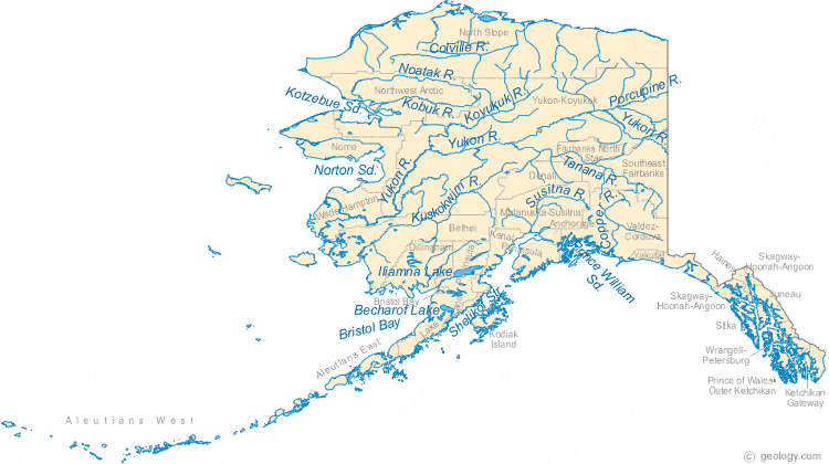
Alaska Rivers Shown on the Map: Colville River, Copper River, Kubuk River, Kuskokwim River, Noatak River, Porcupine River, Susitna River, Tanana River and Yukon River.
Alaska Lakes Shown on the Map: Becharof Lake and Iliamna Lake.
| Alaska Stream and River Levels |
 The United States Geological Survey has a number of stream gages located throughout Alaska. These estimate stream levels, discharges and record them over time. This data is published on the web and many stations allow users to plot custom graphs. Get updated Alaska river and stream levels from USGS here.
| Alaska Stream and River Level Alerts |
 The United States Geological Survey has a system that will send you an email message when flood levels are reached on any stream with USGS gaging equipment that you have selected. Sign up here to receive Alaska stream and river level alerts.
| Alaska Water Publications |
 The United States Geological Survey has a number of publications related to water use and water resources in Alaska. Visit the USGS Alaska Science Center here.

| Alaska Waterfall: Brooks Falls |
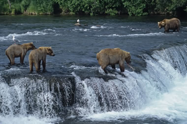 Brooks Falls is located in Katmai National Park and Preserve, between Brooks Lake and Naknek Lake. This waterfall is a famous destination for wildlife photographers. Every year, salmon have to leap up Brooks Falls to reach their spawning ground at Brooks Lake. Because of this, the waterfall has become a seasonal hangout for hungry bears (and brave photographers). In this photo, a mama bear catches a fish as her cubs look on. Image copyright by iStockphoto / JohnPitcher.
| Alaska Drought Map |
 The United States Geological Survey publishes updated drought maps on their website. There you can view a map that shows where below normal 7-day average stream flow conditions were recently recorded. The maps are updated daily. Get a current Alaska drought map here.


Find Other Topics on Geology.com:

|

| ||

|

| ||

|

| ||

|

|