Home » US Maps » Oklahoma » Lakes and Rivers
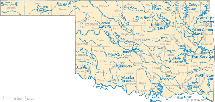
Oklahoma Lakes, Rivers and Water Resources
ADVERTISEMENT
Oklahoma Rivers Shown on the Map: Arkansas River, Beaver River, Bird Creek, Black Bear Creek, Canadian River, Caney River, Cimarron River, Deep Fork, Kiamichi River, Little River, North Canadian River, North Fork Red River, Red River, Salt Fork Arkansas River, Salt Fork Red River, Turkey Creek, Verdigris River, Washita River and Wolf Creek.
Oklahoma Lakes Shown on the Map: Atoka Reservoir, Broken Bow Lake, Canton Lake, Eufaula Reservoir, Fort Gibson Lake, Hugo Lake, Kaw Lake, Keystone Lake, Lake Ellsworth, Lake O' the Cherokee, Lake Texoma, Lake Thunderbird, Oologah Lake, Optima Lake, Robert S. Kerr Reservoir and Waurika Lake.
| Oklahoma Stream and River Levels |
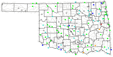 The United States Geological Survey has a number of stream gages located throughout Oklahoma. These estimate stream levels, discharges and record them over time. This data is published on the web and many stations allow users to plot custom graphs. Get updated Oklahoma river and stream levels from USGS here.
| Oklahoma Stream and River Level Alerts |
 The United States Geological Survey has a system that will send you an email message when flood levels are reached on any stream with USGS gaging equipment that you have selected. Sign up here to receive Oklahoma stream and river level alerts.

| Oklahoma Drought Map |
 The United States Geological Survey publishes updated drought maps on their website. There you can view a map that shows where below normal 7-day average stream flow conditions were recently recorded. The maps are updated daily. Get a current Oklahoma drought map here.
| Oklahoma Water Publications |
 The United States Geological Survey has a number of publications related to water use and water resources in Oklahoma. View the Oklahoma-Texas Water Science Center here.
| Oklahoma Elevation Map |
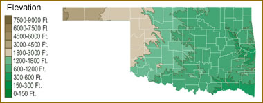 The topography of an area determines the direction of stream flow and often is a primary influence on the geographic distribution of precipitation. View a detailed Oklahoma elevation map.


Find Other Topics on Geology.com:

|

| ||

|

| ||

|

| ||

|

|