Home » US Maps » Texas » Lakes and Rivers
Texas Lakes, Rivers and Water Resources

ADVERTISEMENT
Texas Rivers Shown on the Map: Alamito Creek, Beals Creek, Brazos River, Canadian River, Carrizo Creek, Clear Fork, Colorado River, Concho River, Double Mt. Fork, Frio River, Guadalupe River, Leon River, Llano River, Neches River, Nueces River, Pease River, Pecos River, Prairie Dog Town Fork, Red River, Rio Grande, Rita Blanca Creek, Sabine River, San Antonio River, San Saba River, Sulphur River, Trinity River, West Nueces River, White River and Wichita River.
Texas Lakes Shown on the Map: Amistad Reservoir, Cedar Creek Reservoir, Corpus Christi Bay, Falcon Lake, Galveston Bay, Lake Conroe, Lake Livingston, Lake Meredith, Lake Texoma, Lake Whitney, Matagorda Bay, Ray Roberts Lake, Red Bluff Lake, Sabine Lake, San Antonio Bay, Twin Buttes Reservoir, W. V. Spence Reservoir and Wright Patman Lake.
| Texas Stream and River Levels |
 The United States Geological Survey has a number of stream gages located throughout Texas. These estimate stream levels, discharges and record them over time. This data is published on the web and many stations allow users to plot custom graphs. Get updated Texas river and stream levels from USGS here.
| Texas Stream and River Level Alerts |
 The United States Geological Survey has a system that will send you an email message when flood levels are reached on any stream with USGS gaging equipment that you have selected. Sign up here to receive Texas stream and river level alerts.

| Texas Drought Map |
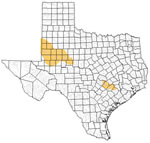 The United States Geological Survey publishes updated drought maps on their website. There you can view a map that shows where below normal 7-day average stream flow conditions were recently recorded. The maps are updated daily. Get a current Texas drought map here.
| Texas Water Publications |
 The United States Geological Survey has a number of publications related to water use and water resources in Texas. Visit the Oklahoma-Texas Water Science Center here.
| Texas Elevation Map |
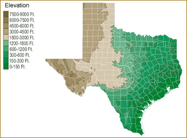 The topography of an area determines the direction of stream flow and often is a primary influence on the geographic distribution of precipitation. View a detailed Texas elevation map.


Find Other Topics on Geology.com:

|

| ||

|

| ||

|

| ||

|

|