Home » Satellite Images » US States » Delaware
Satellite Image of Delaware
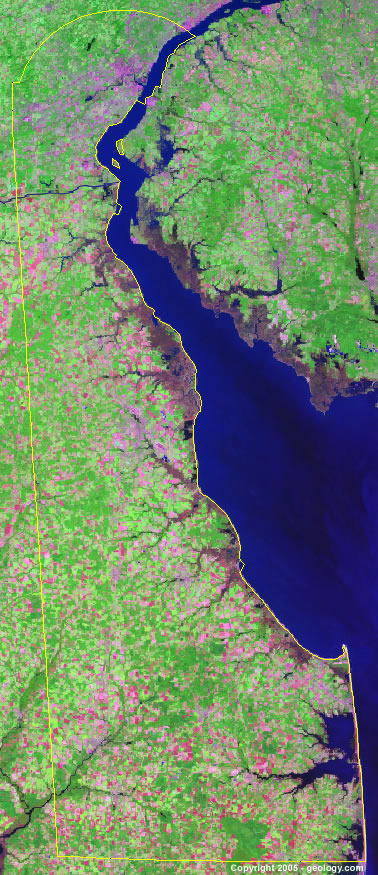
Delaware Satellite Image - View Cities, Rivers, Lakes & Environment
Satellite Images for Neighboring States:
Maryland New Jersey PennsylvaniaThis is a Landsat GeoCover 2000 satellite image map of Delaware. Cities, rivers, lakes, mountains and other features shown in this image include:
Delaware Cities:
Dover, DE
Milford, DE
Newark, DE
Seaford, DE
Wilmington, DE
Delaware Rivers, Lakes, Water Features:
Christina River
Delaware River
Edgar M. Hoopes Reservoir
Killens Pond
Lum's Pond
Mispillion River
Nanticoke River
Red Mill Pond
Shearness Pool
St. Jones River
Other Prominent Delaware Features:
Chesapeake and Delaware Canal
Cypress Swamp
Delaware Bay
Delaware farm land
Indian River Bay
Rehoboth Bay
Shoreline Marshes
ADVERTISEMENT
More Satellite Images
 State Satellite Images: Color Landsat views of all 50 states. Spectacular images.
 Use Google Earth for FREE: Browse seamless worldwide satellite images. Free.
 Earth from Space at Night: Composite images show worldwide patterns of night light and heat.
 Oil & Gas Fields from Space at Night: Drill pad lighting and flaring make them stand out at night.
 Country Satellite Images: Satellite images for over 170 countries from Landsat GeoCover data.
  Satellite Views of US Cities: Images of 120 cities and their surrounding environment.
 Land Below Sea Level: The top ten locations where land is below the level of the ocean.
  Satellite Views of 64 World Cities: Spectacular images showing the city and surrounding environment.
Copyright information: The images on this page were composed by Angela King and are copyright by Geology.com. These images are not available for use beyond our websites. If you would like to share them with others, please link to this page. The satellite image was produced using Landsat data from NASA.