Home » World Maps » Canada » Yukon Territory
Yukon Territory Map - Yukon Territory Satellite Image
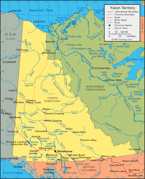
| Yukon Territory is located in northwest Canada. Yukon Territory is bordered by the Beaufort Sea to the north, the United States to the west, Northwest Territories to the east, and British Columbia to the south. |
ADVERTISEMENT
Yukon Territory Bordering Provinces/Territories:
British Columbia, Northwest TerritoriesRegional Maps:
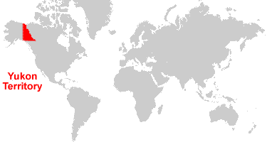
Map of Canada, World MapWhere is Yukon Territory?
Yukon Territory Satellite Image
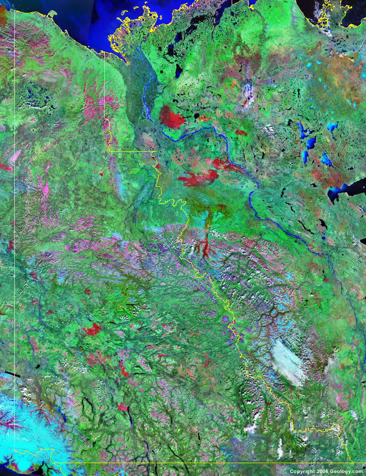
Click for high-resolution image.
ADVERTISEMENT

Explore Yukon Territory, Canada Using Google Earth
Google Earth is a free program from Google that allows you to explore satellite images showing the cities and landscapes of Yukon Territory and all of North America in fantastic detail. It works on your desktop computer, tablet, or mobile phone. The images in many areas are detailed enough that you can see houses, vehicles and even people on a city street. Google Earth is free and easy-to-use.
Canada Topo Maps
Get a custom printed large-format Canadian Topographic Map on waterproof, laminated or glossy paper. You can center the map anywhere in Canada that you want and adjust the scale with easy-to-use tools on the MyTopo website. They will then print and ship your map rolled in a tube or folded neatly in an envelope - your choice.
Yukon Territory, Canada on a World Wall Map
Canada is one of nearly 200 countries illustrated on our Blue Ocean Laminated Map of the World. The Canadian province and territory boundaries are shown on the map along with other political and physical features. It displays symbols for major cities. Major mountains are shown in shaded relief. Ocean depths are indicated with a blue color gradient. This is a great map for students, schools, offices and anywhere that a nice map of the world is needed for education, display or decor.
Yukon Territory, Canada On a Large Wall Map of North America
If you are interested in Yukon Territory and the geography of Canada, our large laminated map of North America might be just what you need. It is a large political map of North America that also shows many of the continent's physical features in color and shaded relief. Major lakes, rivers, cities, roads, country/province/territory boundaries, coastlines and surrounding islands are all shown on the map.Yukon Territory Cities:
Aishihik, Bear Creek, Beaver Creek, Brooks Brook, Burwash Landing, Carcross, Carmacks, Champagne, Clear Creek, Dawson, Destruction Bay, Elsa, Faro, Frances Lake, Gold Creek, Haines Junction, Herschel, Jakes Corner, Keno Hill, Koidern, Mayo, Old Crow, Pelly Crossing, Rancheria, Robinson, Rock Creek, Ross River, Sixtymile, Stewart Crossing, Tagish, Teslin, Upper Liard, Watson Lake, and Whitehorse.Yukon Territory Lakes, Rivers and Locations:
Aishihik Lake, Anvil Range, Beaufort Sea, Bonnet Plume River, Cassiar Mountains, Dezadeash Lake, Donjek River, Frances Lake, Hart River, Hess River, Kluane Lake, Knorr Range, Kusawa Lake, Lake Laberge, Liard River, Little Atlin Lake, Mackenzie Bay, Mackenzie Mountains, Marsh Lake, Miner River, Morris Lake, Peel River, Pelly Mountain, Pelly River, Porcupine River, Richardson Mountains, Ruby Range, Selwyn Mountains, Snake River, St. Cyr Range, Stewart River, Teslin River, White River, Wind River, Wolf Lake, and Yukon River.