Home » Earthquakes » San Andreas Fault
The San Andreas Fault
By David K. Lynch, PhD, author of SanAndreasFault.org.

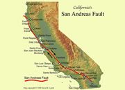
San Andreas Map: The red line on this map follows the surface trace of the San Andreas Fault across California. Areas to the east (right) of the fault are on the North American tectonic plate. Areas to the west (left) of the fault are part of the Pacific tectonic plate. The arrows show the directions of relative motion along the fault. Map copyright by David Lynch (click to enlarge).
What is the San Andreas Fault?
The San Andreas Fault is the sliding boundary between the Pacific Plate and the North American Plate. It slices California in two from Cape Mendocino to the Mexican border. San Diego, Los Angeles and Big Sur are on the Pacific Plate. San Francisco, Sacramento and the Sierra Nevada are on the North American Plate. And despite San Francisco’s legendary 1906 earthquake, the San Andreas Fault does not go through the city. But communities like Desert Hot Springs, San Bernardino, Wrightwood, Palmdale, Gorman, Frazier Park, Daly City, Point Reyes Station and Bodega Bay lie squarely on the fault and are sitting ducks.
What Type of Fault is the San Andreas?
The San Andreas Fault is a transform fault. Imagine placing two slices of pizza on the table and sliding them past one another where they touch along a common straight edge. Bits of pepperoni from one side crumble across the boundary onto the anchovy side. The same thing happens with the fault, and the geology and landforms along the mighty rift are extremely complicated.
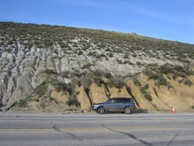
You Can See a Plate Boundary! Photo of the San Andreas Fault near Gorman, California, showing rocks of the Pacific Plate (gray rocks on the left side of the fault) and the North American Plate (tan rocks on the right side of the fault). There are very few places on Earth where you can see two plates in contact like this. Photograph copyright by David Lynch. Click to enlarge.
How Fast Does It Move?
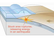
The plates are slowly moving past one another at a couple of inches a year - about the same rate that your fingernails grow. But this is not a steady motion, it is the average motion. For years the plates will be locked with no movement at all as they push against one another. Suddenly the built-up strain breaks the rock along the fault, and the plates slip a few feet all at once. The breaking rock sends out waves in all directions, and it is the waves that we feel as earthquakes.
Is the Fault Visible at the Surface?
In many places like the Carrizo Plain (San Luis Obispo County) and the Olema Trough (Marin County), the fault is easy to see as a series of scarps and pressure ridges. In other places, it is more subtle because the fault hasn’t moved in many years and is covered with alluvium, or overgrown with brush. In San Bernardino and Los Angeles Counties, many of the roads along the fault cut through great mountains of gouge, the powdery, crumbled rock that has been pulverized by the moving plates.
The hallmark of the San Andreas Fault is the different rocks on either side of it. Being about 28 million years old, rocks from great distances have been juxtaposed against rocks from very different locations and origins. The Salinian block of granite in central and northern California originated in Southern California, and some even say northern Mexico. Pinnacles National Monument in Monterey County is only half of a volcanic complex, the other part being 200 miles southeast in Los Angeles County and known as the Neenach Volcanics.
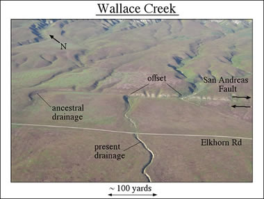
Offset Drainage: Aerial photo of the San Andreas Fault showing drainage that is offset by movement of the fault. Photograph copyright by David Lynch. Click to enlarge.
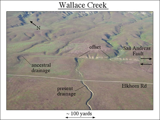
Fault Myths
There are many myths and legends about the San Andreas Fault, the biggest being that it will one day crack and California will slide into the sea. WRONG! It won’t happen and it can’t happen. Nor is there any thing such as “earthquake weather” or preferred times of day when earthquakes hit.
The World's Most Famous Fault
The San Andreas Fault is more accessible than any other fault in the world. With California’s large population and temperate climate, there are many roads that snake along the fault. They are uncrowded and peaceful, perfect for family outings. There is abundant camping, bird watching, wild flowers and wildlife, rock collecting and natural beauty along the way. State and National parks are strung along the fault like beads on a string. All it takes is a good map, a comfortable car and a desire to see the world’s most famous fault.
About the Author
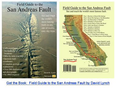
David K. Lynch, PhD, is an astronomer and planetary scientist living in Topanga, CA. When not hanging around the fault or using the large telescopes on Mauna Kea, he plays fiddle, collects rattlesnakes, gives public lectures on rainbows and writes books (Color and Light in Nature, Cambridge University Press) and essays. Dr. Lynch's latest book is the Field Guide to the San Andreas Fault. The book contains twelve one-day driving trips along different parts of the fault, and includes mile-by-mile road logs and GPS coordinates for hundreds of fault features. As it happens, Dave's house was destroyed in 1994 by the magnitude 6.7 Northridge earthquake.
| More Earthquakes |
 |
What is the San Andreas Fault? |
 |
What Causes a Tsunami? |
 |
Largest Earthquake |
 |
California Earthquake Maps |
 |
Teaching Plate Tectonics |
 |
Earthquake Lessons |
 |
Gifts That Rock |
 |
The Japan Earthquake |

Find Other Topics on Geology.com:

|

| ||

|

| ||

|

| ||

|

|