Home » US Maps » Colorado » Lakes and Rivers
Colorado Lakes, Rivers and Water Resources

ADVERTISEMENT
Colorado Rivers Shown on the Map: Animas River, Apishapa River, Arikaree River, Arkansas River, Beaver Creek, Big Sandy Creek, Blue River, Box Elder Creek, Cache la Poudre River, Cherry Creek, Colorado River, Dolores River, Gunnison River, Huerfano River, Laramie River, Little Snake River, Mancos River, North Platte River, Platte River, Purgatoire River, Rio Grande, Rush Creek, San Miguel River, South Fork Republican River, South Platte River, Two Butte Creek, Uncompahgre River, White River and Yampa River.
Colorado Lakes Shown on the Map: Blue Mesa Reservoir, John Martin Reservoir and Lake Granby.
| Colorado Elevation Map |
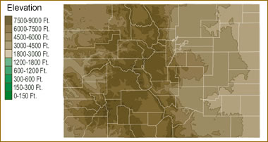 The topography of an area determines the direction of stream flow and often is a primary influence on the geographic distribution of precipitation. View a detailed Colorado elevation map.
| Colorado Stream and River Levels |
 The United States Geological Survey has a number of stream gages located throughout Colorado. These estimate stream levels, discharges and record them over time. This data is published on the web and many stations allow users to plot custom graphs. Get updated Colorado river and stream levels from USGS here.
| Colorado Stream and River Level Alerts |
 The United States Geological Survey has a system that will send you an email message when flood levels are reached on any stream with USGS gaging equipment that you have selected. Sign up here to receive Colorado stream and river level alerts.
| Colorado Water Publications |
 The United States Geological Survey has a number of publications related to water use and water resources in Colorado. Visit the Colorado Water Science Center here.

| Colorado Waterfall: Bridal Veil Falls |
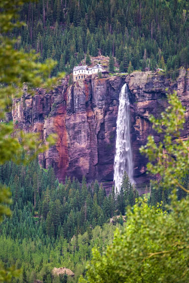 Bridal Veil Falls is the highest waterfall in Colorado, at a height of 365 feet. It is a two-pronged waterfall which overlooks the town of Telluride. The hydroelectric power plant at the top of the falls was built in 1907, and it is listed on the National Register of Historic Places. The plant now provides about 25% of the electricity used in Telluride. The town is a popular destination for ice climbers, and the frozen Bridal Veil Falls is regarded as a particularly challenging and dangerous climb. Image copyright iStockphoto / thittaya itthithepphana.
| Colorado Drought Map |
 The United States Geological Survey publishes updated drought maps on their website. There you can view a map that shows where below normal 7-day average stream flow conditions were recently recorded. The maps are updated daily. Get a current Colorado drought map here.


Find Other Topics on Geology.com:

|

| ||

|

| ||

|

| ||

|

|