Home » US Maps » Georgia » Lakes and Rivers
Georgia Lakes, Rivers and Water Resources

ADVERTISEMENT
Georgia Rivers Shown on the Map: Alapaha River, Altamaha River, Brier Creek, Broad River, Canoche River, Chattahoochee River, Etowah River, Flint River, Ochlockonee River, Ocmulgee River, Oconee River, Ogeechee River, Ohoopee River, Oostanaula River, Satilla River, Savannah River, St. Marys River and Withlacoochee River.
Georgia Lakes Shown on the Map: Allatoona Lake, Blue Ridge Lake, Hartwell Lake, J. Strom Thurmond Reservoir, Jackson Lake, Lake Blackshear, Lake Burton, Lake Oconee, Lake Seminole, Lake Sidney Lanier, Lake Sinclair, Russell Lake, Walter F. George Reservoir, Weiss Lake and West Point Lake.
| Georgia Stream and River Levels |
 The United States Geological Survey has a number of stream gages located throughout Georgia. These estimate stream levels, discharges and record them over time. This data is published on the web and many stations allow users to plot custom graphs. Get updated Georgia river and stream levels from USGS here.
| Georgia Stream and River Level Alerts |
 The United States Geological Survey has a system that will send you an email message when flood levels are reached on any stream with USGS gaging equipment that you have selected. Sign up here to receive Georgia stream and river level alerts.

| Georgia Drought Map |
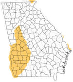 The United States Geological Survey publishes updated drought maps on their website. There you can view a map that shows where below normal 7-day average stream flow conditions were recently recorded. The maps are updated daily. Get a current Georgia drought map here.
| Georgia Water Publications |
 The United States Geological Survey has a number of publications related to water use and water resources in Georgia. Visit the South Atlantic Water Science Center here.
| Georgia Elevation Map |
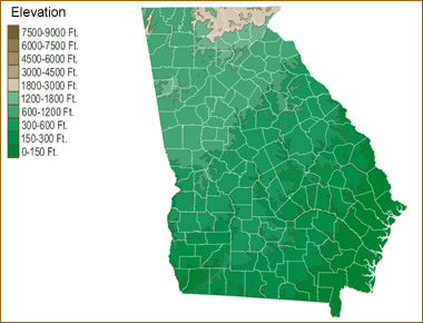 The topography of an area determines the direction of stream flow and often is a primary influence on the geographic distribution of precipitation. View a detailed Georgia elevation map.


Find Other Topics on Geology.com:

|

| ||

|

| ||

|

| ||

|

|