Home » US Maps » Missouri » Lakes and Rivers
Missouri Lakes, Rivers and Water Resources

ADVERTISEMENT
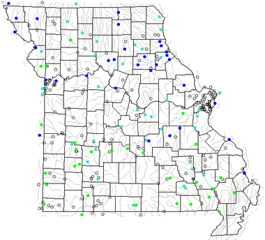
Missouri Rivers Shown on the Map: Big Piney River, Black River, Blackwater River, Bourbeuse River, Charriton River, Cuivre River, Current River, Eleven Point River, Gasconade River, Grand River, James River, Lamine River, Locust Creek, Marais des Cygnes River, Meramec River, Mississippi River, Missouri River, Mussel Fork, Niangua River, North Fabius River, North Fork Salt River, Osage River, Platte River, Sac River, Salt River, South Grand River, St. Francis River and Thompson River.
Missouri Lakes Shown on the Map: Bull Shoals Lake, Harry S. Truman Reservoir, Lake of the Ozarks, Mark Twain Lake, Stockton Lake, Table Rock Lake and Thomas Hill Reservoir.
| Missouri Stream and River Levels |
 The United States Geological Survey has a number of stream gages located throughout Missouri. These estimate stream levels, discharges and record them over time. This data is published on the web and many stations allow users to plot custom graphs. Get updated Missouri river and stream levels from USGS here.
| Missouri Stream and River Level Alerts |
 The United States Geological Survey has a system that will send you an email message when flood levels are reached on any stream with USGS gaging equipment that you have selected. Sign up here to receive Missouri stream and river level alerts.

| Missouri Drought Map |
 The United States Geological Survey publishes updated drought maps on their website. There you can view a map that shows where below normal 7-day average stream flow conditions were recently recorded. The maps are updated daily. Get a current Missouri drought map here.
| Missouri Water Publications |
 The United States Geological Survey has a number of publications related to water use and water resources in Missouri. Visit the Central Midwest Water Science Center here.
| Missouri Elevation Map |
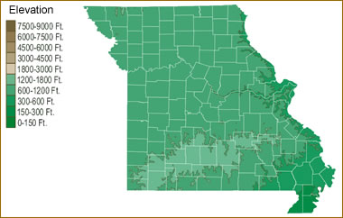 The topography of an area determines the direction of stream flow and often is a primary influence on the geographic distribution of precipitation. View a detailed Missouri elevation map.


Find Other Topics on Geology.com:

|

| ||

|

| ||

|

| ||

|

|