Home » US Maps » Missouri » County Map
Missouri County Map with County Seat Cities

ADVERTISEMENT
County Maps for Neighboring States:
Arkansas Illinois Iowa Kansas Kentucky Nebraska Oklahoma Tennessee
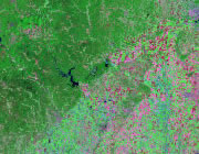


The map above is a Landsat satellite image of Missouri with County boundaries superimposed. We have a more detailed satellite image of Missouri without County boundaries.


ADVERTISEMENT
Missouri Counties and County Seats |
|
|
Adair County - Kirksville Andrew County - Savannah Atchison County - Rock Port Audrain County - Mexico Barry County - Cassville Barton County - Lamar Bates County - Butler Benton County - Warsaw Bollinger County - Marble Hill Boone County - Columbia Buchanan County - St. Joseph Butler County - Poplar Bluff Caldwell County - Kingston Callaway County - Fulton Camden County - Camdenton Cape Girardeau County - Jackson Carroll County - Carrollton Carter County - Van Buren Cass County - Harrisonville Cedar County - Stockton Chariton County - Keytesville Christian County - Ozark Clark County - Kahoka Clay County - Liberty Clinton County - Plattsburg Cole County - Jefferson City Cooper County - Boonville Crawford County - Steelville Dade County - Greenfield Dallas County - Buffalo Daviess County - Gallatin De Kalb County - Maysville Dent County - Salem Douglas County - Ava Dunklin County - Kennett Franklin County - Union Gasconade County - Hermann Gentry County - Albany Greene County - Springfield Grundy County - Trenton Harrison County - Bethany Henry County - Clinton Hickory County - Hermitage Holt County - Oregon Howard County - Fayette Howell County - West Plains Iron County - Ironton Jackson County - Independence Jasper County - Carthage Jefferson County - Hillsboro Johnson County - Warrensburg Knox County - Edina Laclede County - Lebanon Lafayette County - Lexington Lawrence County - Mount Vernon Lewis County - Monticello Lincoln County - Troy |
Linn County - Linneus Livingston County - Chillicothe Macon County - Macon Madison County - Fredericktown Maries County - Vienna Marion County - Palmyra McDonald County - Pineville Mercer County - Princeton Miller County - Tuscumbia Mississippi County - Charleston Moniteau County - California Monroe County - Paris Montgomery County - Montgomery City Morgan County - Versailles New Madrid County - New Madrid Newton County - Neosho Nodaway County - Maryville Oregon County - Alton Osage County - Linn Ozark County - Gainesville Pemiscot County - Caruthersville Perry County - Perryville Pettis County - Sedalia Phelps County - Rolla Pike County - Bowling Green Platte County - Platte City Polk County - Bolivar Pulaski County - Waynesville Putnam County - Unionville Ralls County - New London Randolph County - Huntsville Ray County - Richmond Reynolds County - Centerville Ripley County - Doniphan Saline County - Marshall Schuyler County - Lancaster Scotland County - Memphis Scott County - Benton Shannon County - Eminence Shelby County - Shelbyville St. Charles County - St. Charles St. Clair County - Osceola St. Francois County - Farmington St. Louis County - Clayton Ste. Genevieve County - Ste. Genevieve Stoddard County - Bloomfield Stone County - Galena Sullivan County - Milan Taney County - Forsyth Texas County - Houston Vernon County - Nevada Warren County - Warrenton Washington County - Potosi Wayne County - Greenville Webster County - Marshfield Worth County - Grant City Wright County - Hartville |
