Home » US Maps » Arkansas » County Map
Arkansas County Map with County Seat Cities

ADVERTISEMENT
County Maps for Neighboring States:
Louisiana Mississippi Missouri Oklahoma Tennessee Texas
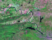


The map above is a Landsat satellite image of Arkansas with County boundaries superimposed. We have a more detailed satellite image of Arkansas without County boundaries.


ADVERTISEMENT
Arkansas Counties and County Seats |
|
|
Arkansas County - De Witt, Stuttgart Ashley County - Hamburg Baxter County - Mountain Home Benton County - Bentonville Boone County - Harrison Bradley County - Warren Calhoun County - Hampton Carroll County - Berryville , Eureka Springs Chicot County - Lake Village Clark County - Arkadelphia Clay County - Piggott, Corning Cleburne County - Heber Springs Cleveland County - Rison Columbia County - Magnolia Conway County - Morrilton Craighead County - Lake City, Jonesboro Crawford County - Van Buren Crittenden County - Marion Cross County - Wynne Dallas County - Fordyce Desha County - Arkansas City Drew County - Monticello Faulkner County - Conway Franklin County - Charleston, Ozark Fulton County - Salem Garland County - Hot Springs Grant County - Sheridan Green County - Paragould Hempstead County - Hope Hot Spring County - Malvern Howard County - Nashville Independence County - Batesville Izard County - Melbourne Jackson County - Newport Jefferson County - Pine Bluff Johnson County - Clarksville Lafayette County - Lewisville Lawrence County - Walnut Ridge |
Lee County - Marianna Lincoln County - Star City Little River County - Ashdown Logan County - Booneville, Paris Lonoke County - Lonoke Madison County - Huntsville Marion County - Yellville Miller County - Texarkana Mississippi County - Blytheville, Osceola Monroe County - Clarendon Montgomery County - Mount Ida Nevada County - Prescott Newton County - Jasper Ouachita County - Camden Perry County - Perryville Phillips County - Helena-West Helena Pike County - Murfreesboro Poinsett County - Harrisburg Polk County - Mena Pope County - Russellville Prairie County - Des Arc , De Valls Bluff Pulaski County - Little Rock Randolph County - Pocahontas St. Francis County - Forrest City Saline County - Benton Scott County - Waldron Searcy County - Marshall Sebastian County - Greenwood, Fort Smith Sevier County - De Queen Sharp County - Ash Flat Stone County - Mountain View Union County - El Dorado Van Buren County - Clinton Washington County - Fayetteville White County - Searcy Woodruff County - Augusta Yell County - Dardanelle, Danville |
