Home » US Maps » Kansas » County Map
Kansas County Map with County Seat Cities

ADVERTISEMENT
County Maps for Neighboring States:
Colorado Missouri Nebraska Oklahoma
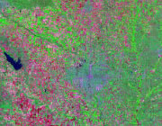


The map above is a Landsat satellite image of Kansas with County boundaries superimposed. We have a more detailed satellite image of Kansas without County boundaries.


ADVERTISEMENT
Kansas Counties and County Seats |
|
|
Allen County - Iola Anderson County - Garnett Atchison County - Atchison Barber County - Medicine Lodge Barton County - Great Bend Bourbon County - Fort Scott Brown County - Hiawatha Butler County - El Dorado Chase County - Cottonwood Falls Chautauqua County - Sedan Cherokee County - Columbus Cheyenne County - St. Francis Clark County - Ashland Clay County - Clay Center Cloud County - Concordia Coffey County - Burlington Comanche County - Coldwater Cowley County - Winfield Crawford County - Girard Decatur County - Oberlin Dickinson County - Abilene Doniphan County - Troy Douglas County - Lawrence Edwards County - Kinsley Elk County - Howard Ellis County - Hays Ellsworth County - Ellsworth Finney County - Garden City Ford County - Dodge City Franklin County - Ottawa Geary County - Junction City Gove County - Gove Graham County - Hill City Grant County - Ulysses Gray County - Cimarron Greeley County - Tribune Greenwood County - Eureka Hamilton County - Syracuse Harper County - Anthony Harvey County - Newton Haskell County - Sublette Hodgeman County - Jetmore Jackson County - Holton Jefferson County - Oskaloosa Jewell County - Mankato Johnson County - Olathe Kearny County - Lakin Kingman County - Kingman Kiowa County - Greensburg Labette County - Oswego Lane County - Dighton Leavenworth County - Leavenworth Lincoln County - Lincoln Center |
Linn County - Mound City Logan County - Oakley Lyon County - Emporia Marion County - Marion Marshall County - Marysville McPherson County - McPherson Meade County - Meade Miami County - Paola Mitchell County - Beloit Montgomery County - Independence Morris County - Council Grove Morton County - Elkhart Nemaha County - Seneca Neosho County - Erie Ness County - Ness City Norton County - Norton Osage County - Lyndon Osborne County - Osborne Ottawa County - Minneapolis Pawnee County - Larned Phillips County - Phillipsburg Pottawatomie County - Westmoreland Pratt County - Pratt Rawlins County - Atwood Reno County - Hutchinson Republic County - Belleville Rice County - Lyons Riley County - Manhattan Rooks County - Stockton Rush County - La Crosse Russell County - Russell Saline County - Salina Scott County - Scott City Sedgwick County - Wichita Seward County - Liberal Shawnee County - Topeka Sheridan County - Hoxie Sherman County - Goodland Smith County - Smith Center Stafford County - St. John Stanton County - Johnson City Stevens County - Hugoton Sumner County - Wellington Thomas County - Colby Trego County - WaKeeney Wabaunsee County - Alma Wallace County - Sharon Springs Washington County - Washington Wichita County - Leoti Wilson County - Fredonia Woodson County - Yates Center Wyandotte County - Kansas City |
