Home » US Maps » North Dakota » Lakes and Rivers
North Dakota Lakes, Rivers and Water Resources
ADVERTISEMENT
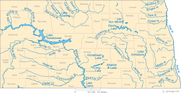
North Dakota Rivers Shown on the Map: Beaver Creek, Cannonball River, Cedar Creek, Cut Bank Creek, Des Lacs River, Forest River, Goose River, Heart River, James River, Knife River, Little Missouri River, Little Muddy River, Maple River, Missouri River, Park River, Pembina River, Pipestem Creek, Red River, Sheyenne River, Souris River, Spring Creek, Tongue River, White Earth River and Wild Rice River.
North Dakota Lakes Shown on the Map: Alkaline Lake, Devils lake, Horsehead Lake, Lac Aux Morts, Lake Ashtabu, Lake Darling, Lake Oahe, Lake Sakakawea and Long Lake.
| North Dakota Stream and River Levels |
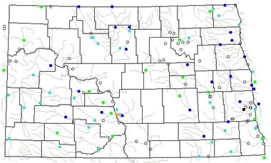 The United States Geological Survey has a number of stream gages located throughout North Dakota. These estimate stream levels, discharges and record them over time. This data is published on the web and many stations allow users to plot custom graphs. Get updated North Dakota river and stream levels from USGS here.
| North Dakota Stream and River Level Alerts |
 The United States Geological Survey has a system that will send you an email message when flood levels are reached on any steam with USGS gaging equipment that you have selected. Sign up here to recieve North Dakota stream and river level alerts.

| North Dakota Drought Map |
 The United States Geological Survey publishes updated drought maps on their website. There you can view a map that shows where below normal 7-day average stream flow conditions were recently recorded. The maps are updated daily. Get a current North Dakota drought map here.
| North Dakota Water Publications |
 The United States Geological Survey has a number of publications related to water use and water resources in North Dakota. Visit the Dakota Water Science Center here.
| North Dakota Elevation Map |
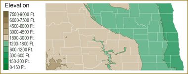 The topography of an area determines the direction of stream flow and often is a primary influence on the geographic distribution of precipitation. View a detailed North Dakota elevation map.


Find Other Topics on Geology.com:

|

| ||

|

| ||

|

| ||

|

|