Home » US Maps » Virginia » Lakes and Rivers
Virginia Lakes, Rivers and Water Resources

ADVERTISEMENT
Virginia Rivers Shown on the Map: Appomattox River, Blackwater River, Clinch River, Dan River, Jackson River, James River, Maury River, Meherrin River, New River, North Fork Holston River, Nottoway River, Potomac River, Powell River, Rapidan River, Rappahannock River, Rivanna River, Roanoke River, Smith River, South Anna River and South Fork Shenandoah River.
Virginia Lakes Shown on the Map: John H. Kerr Reservoir, Lake Anna, Lake Chesdin, Smith Mountain Lake and South Holston Lake.
| Virginia Stream and River Levels |
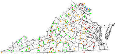 The United States Geological Survey has a number of stream gages located throughout Virginia. These estimate stream levels, discharges and record them over time. This data is published on the web and many stations allow users to plot custom graphs. Get updated Virginia river and stream levels from USGS here.
| Virginia Stream and River Level Alerts |
 The United States Geological Survey has a system that will send you an email message when flood levels are reached on any stream with USGS gaging equipment that you have selected. Sign up here to receive Virginia stream and river level alerts.

| Virginia Drought Map |
 The United States Geological Survey publishes updated drought maps on their website. There you can view a map that shows where below normal 7-day average stream flow conditions were recently recorded. The maps are updated daily. Get a current Virginia drought map here.
| Virginia Water Publications |
 The United States Geological Survey has a number of publications related to water use and water resources in Virginia. Visit the Virginia and West Virginia Water Science Center here.
| Virginia Elevation Map |
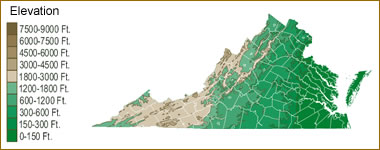 The topography of an area determines the direction of stream flow and often is a primary influence on the geographic distribution of precipitation. View a detailed Virginia elevation map.


Find Other Topics on Geology.com:

|

| ||

|

| ||

|

| ||

|

|