Home » US Maps » California Maps
California Map Collection

California County Map:
This map shows California's 58 counties. Also available is a detailed California County Map with county seat cities.
ADVERTISEMENT


Map of California Cities:
This map shows many of California's important cities and most important roads. Important north - south routes include: Interstate 5 and Interstate 15. Important east - west routes include: Interstate 8, Interstate 10, Interstate 40 and Interstate 80. We also have a more detailed Map of California Cities.

California Physical Map:
This California shaded relief map shows the major physical features of the state. For other nice views of the state, see our California Satellite image or the California map by Google.
ADVERTISEMENT

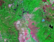
California Rivers Map:
This map shows the major streams and rivers of California and some of the larger lakes. Most of California is in the Pacific Ocean watershed. Major streams that drain to the Pacific include the San Joaquin, Salinas, Russian, Eel and Trinity Rivers. Small parts of eastern California are in the Great Basin, an area of the United States that does not drain into any ocean but instead drainage flows into local basin such as Lake Tahoe or Mono Lake. Most of these lakes and streams can be clearly seen on the California Satellite Image. We also have a page about California water resources.

California Elevation Map:
This is a generalized topographic map of California. It shows elevation trends across the state. Detailed topographic maps and aerial photos of California are available in the Geology.com store. See our state high points map to learn about Mt. Whitney at 14,494 feet - the highest point in California. The lowest point is Death Valley at -282 feet.