Home » Satellite Images » US States » California
Satellite Image of California
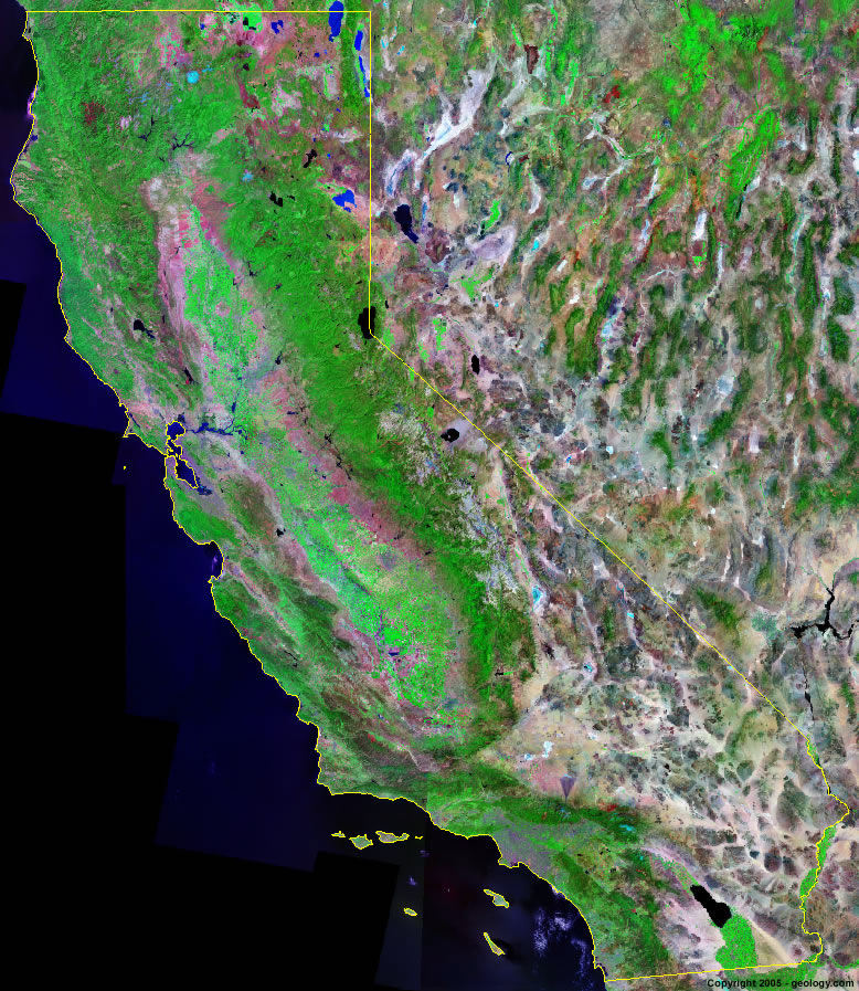
California Satellite Image - View Cities, Rivers, Lakes & Environment
Satellite Images for Neighboring States:
Arizona Nevada OregonThis is a Landsat GeoCover 2000 satellite image map of California. Cities, rivers, lakes, mountains and other features shown in this image include:
California Cities:
Bakersfield
Berkeley
Fresno
Los Angeles
Oakland
Sacramento
San Diego
San Francisco
San Jose
Santa Barbera
California Rivers, Lakes, Water Features:
Sacramento River
Colorado River
San Joaquin River
Mokelumne River
Stanislavs River
Merced River
King River
Clear Lake Reservoir
Goose Lake
Clair Engle Lake
Shasta Lake
Middle Alkali Lake
Eagle Lake
Lake Almanor
Lake Tahoe
Clear Lake
Lake Berryessa
Camanche Reservoir
New Melones Lake
Don Pedro Reservoir
Lake McClure
Turlock Lake
San Luis Reservoir
Salton Sea
Mono LakeReading, CA
Sacramento, CA
San Francisco, CA
Stockton, CA
San Jose, CA
Santa Rosa, CA
Fresno, CA
Bakersfield, CA
Los Angeles, CA
Riverside, CA
San Bernardino, CA
San Diego, CA
Modesto, CA
Other Prominent California Features:
Mt. Lassen
Mt. Shasta
Sierra Nevada Mountains
Warner Mountains
Klamoth Mountains
Coast Ranges
San Joaquin Valley
Yosemite National Park
Santa Lucia Range
Sierra Madre Mountains
San Rafael Mountains
Chocolate Mountains
Santa Rosa Mountains
San Bernardino Mountains
Mojave Desert
Death Valley
California farm land
ADVERTISEMENT
More Satellite Images
 State Satellite Images: Color Landsat views of all 50 states. Spectacular images.
 Use Google Earth for FREE: Browse seamless worldwide satellite images. Free.
 Earth from Space at Night: Composite images show worldwide patterns of night light and heat.
 Oil & Gas Fields from Space at Night: Drill pad lighting and flaring make them stand out at night.
 Country Satellite Images: Satellite images for over 170 countries from Landsat GeoCover data.
  Satellite Views of US Cities: Images of 120 cities and their surrounding environment.
 Land Below Sea Level: The top ten locations where land is below the level of the ocean.
  Satellite Views of 64 World Cities: Spectacular images showing the city and surrounding environment.
Copyright information: The images on this page were composed by Angela King and are copyright by Geology.com. These images are not available for use beyond our websites. If you would like to share them with others, please link to this page. The satellite image was produced using Landsat data from NASA.