Montana Map Collection
Montana County Map:
This map shows Montana's 56 counties. Also available is a detailed Montana County Map with county seat cities.
ADVERTISEMENT


Map of Montana Cities:
This map shows many of Montana's important cities and most important roads. The important north - south route is Interstate 15. The Important east - west route is Interstate 90. We also have a more detailed Map of Montana Cities.
Montana Physical Map:
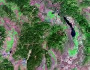
This Montana shaded relief map shows the major physical features of the state. For other nice views of the state, see our Montana Satellite image or the Montana map by Google.
ADVERTISEMENT

Montana Rivers Map:
This map shows the major streams and rivers of Montana and some of the larger lakes. The Great Continental Divide and the Northern Divide pass through Montana. The eastern part of the state is in the Gulf of America Drainage Basin and much of the drainage leaves the state through the Missouri and Yellowstone Rivers. The western part of the state is in the Pacific Ocean Watershed. A small area in the Glacier National Park area is within the Arctic Ocean Watershed. Here, Triple Divide Peak marks the intersection of the Great Continental Divide and the Northern Divide. Most of these lakes and streams can be clearly seen on the Montana Satellite Image. We also have a page about Montana water resources.
Montana Elevation Map:
This is a generalized topographic map of Montana. It shows elevation trends across the state. Detailed topographic maps and aerial photos of Montana are available in the Geology.com store. See our state high points map to learn about Granite Peak at 12,799 feet - the highest point in Montana. The lowest point is the Kootenai River at 1,800 feet.