Home » World Maps » Europe » Sweden
Sweden Map and Satellite Image

| Sweden is located in northern Europe. Sweden is bordered by the Gulf of Bothnia and Baltic Sea, with Norway to the west and Finland to the east. |
ADVERTISEMENT
Sweden Bordering Countries:
Finland, NorwayRegional Maps:
Map of Europe, World Map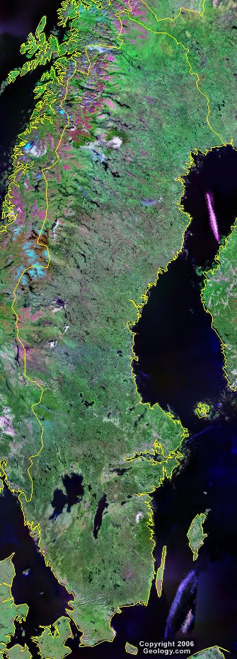
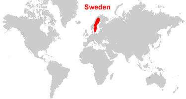
Where is Sweden?

Explore Sweden Using Google Earth:
Google Earth is a free program from Google that allows you to explore satellite images showing the cities and landscapes of Sweden and all of Europe in fantastic detail. It works on your desktop computer, tablet, or mobile phone. The images in many areas are detailed enough that you can see houses, vehicles and even people on a city street. Google Earth is free and easy-to-use.
Sweden on a World Wall Map:
Sweden is one of nearly 200 countries illustrated on our Blue Ocean Laminated Map of the World. This map shows a combination of political and physical features. It includes country boundaries, major cities, major mountains in shaded relief, ocean depth in blue color gradient, along with many other features. This is a great map for students, schools, offices and anywhere that a nice map of the world is needed for education, display or decor.
Sweden On a Large Wall Map of Europe:
If you are interested in Sweden and the geography of Europe our large laminated map of Europe might be just what you need. It is a large political map of Europe that also shows many of the continent's physical features in color or shaded relief. Major lakes, rivers,cities, roads, country boundaries, coastlines and surrounding islands are all shown on the map.ADVERTISEMENT
Sweden Cities:
Arvika, Borad, Gallivare, Gavle, Goteborg, Halmstad, Harnosand, Helsingborg, Hudiksvall, Jonkoping, Kalmar, Karlstad, Kiruna, Kramfors, Linkoping, Lulea, Malmo, Norrkoping, Orebro, Ornskoldsvik, Ostersund, Ronneby, Skelleftea, Soderhamn, Sodertalje, Solleftea, Stockholm, Sundsvall, Umea, Uppsala and Vasteras.Sweden Locations:
Angermanalven, Baltic Sea, Gulf of Bothnia, Gulf of Finland, Gulf of Riga, Harefjorden, Hjalmaren, Hudiksvallsfjorden, Irbe Strait, Kalmarsund, Kattegat, Lovstabukten, Lulevatten, Malaren, Norwegian Sea, Oregrundsgrepen, Siljan, Skagerrak, Skelleftealven, Stora Sundsvallsbukten, Tornealven, Tornetrask, Vanern and Vattern.Sweden Natural Resources:
Sweden has a number of mineral and metal resources which include iron ore, copper, lead, zinc, gold, silver, tungsten, uranium, arsenic and feldspar. Other natural resources for the country include timber and hydropower.Sweden Natural Hazards:
The waters surrounding Sweden are subject to ice floes, especially in the Gulf of Bothnia, interfering with maritime traffic.Sweden Environmental Issues:
An environmental issue for Sweden is the acid rain which is damaging the country's soils and lakes. There is also pollution of the North Sea and the Baltic Sea.
ADVERTISEMENT