Home » US Maps » New Mexico » County Map
New Mexico County Map with County Seat Cities

ADVERTISEMENT
County Maps for Neighboring States:
Arizona Colorado Oklahoma Texas Utah
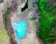


The map above is a Landsat satellite image of New Mexico with County boundaries superimposed. We have a more detailed satellite image of New Mexico without County boundaries.


ADVERTISEMENT
New Mexico Counties and County Seats |
|
|
Bernalillo County - Albuquerque Catron County - Reserve Chaves County - Roswell Cibola County - Grants Colfax County - Raton Curry County - Clovis De Baca County - Fort Sumner Doña Ana County - Las Cruces Eddy County - Carlsbad Grant County - Silver City Guadalupe County - Santa Rosa Harding County - Mosquero Hidalgo County - Lordsburg Lea County - Lovington Lincoln County - Carrizozo Los Alamos County - Los Alamos Luna County - Deming |
McKinley County - Gallup Mora County - Mora Otero County - Alamogordo Quay County - Tucumcari Rio Arriba County - Tierra Amarilla Roosevelt County - Portales San Juan County - Aztec San Miguel County - Las Vegas Sandoval County - Bernalillo Santa Fe County - Santa Fe Sierra County - Truth or Consequences Socorro County - Socorro Taos County - Taos Torrance County - Estancia Union County - Clayton Valencia County - Los Lunas |
