Home » US Maps » Utah » County Map
Utah County Map with County Seat Cities

ADVERTISEMENT
County Maps for Neighboring States:
Arizona Colorado Idaho Nevada New Mexico Wyoming
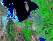


The map above is a Landsat satellite image of Utah with County boundaries superimposed. We have a more detailed satellite image of Utah without County boundaries.


ADVERTISEMENT
Utah Counties and County Seats |
|
|
Beaver County - Beaver Box Elder County - Brigham City Cache County - Logan Carbon County - Price Daggett County - Manila Davis County - Farmington Duchesne County - Duchesne Emery County - Castle Dale Garfield County - Panguitch Grand County - Moab Iron County - Parowan Juab County - Nephi Kane County - Kanab Millard County - Fillmore Morgan County - Morgan |
Piute County - Junction Rich County - Randolph Salt Lake County - Salt Lake City San Juan County - Monticello Sanpete County - Manti Sevier County - Richfield Summit County - Coalville Tooele County - Tooele Uintah County - Vernal Utah County - Provo Wasatch County - Heber City Washington County - St. George Wayne County - Loa Weber County - Ogden |
