Home » US Maps » Arkansas » Lakes and Rivers
Arkansas Lakes, Rivers and Water Resources

ADVERTISEMENT
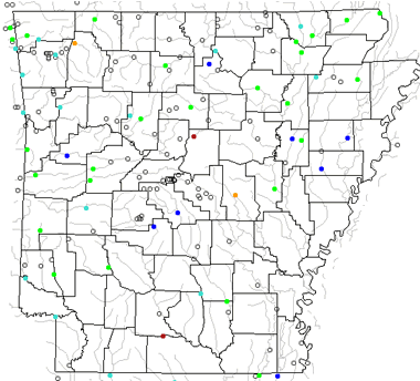
Arkansas Rivers Shown on the Map: Arkansas River, Bayou Bartholomew, Bayou DeView, Bayou Meto, Black River, Buffalo River, Cache River, Caddo River, Cossatot River, Fourche LaFave River, Hurricane Creek, Kings River, L'Anguille River, Little Missouri River, Little Red River, Mississippi River, Moro Creek, Mulberry River, Ouachita River, Petit Jean River, Red River, Saline River, Spring River, St. Francis River, Strawberry River and White River
Arkansas Lakes Shown on the Map: Beaver Lake, Bull Shoals Reservoir, Dardanelle Reservoir, DeGray Lake, Greens Ferry Lake, Lake Erling, Lake Greeson, Lake Hamilton, Lake Jack Lee, Lake Maumelle, Lake Ouachita, Millwood Reservoir and Norfork Lake.
| Arkansas Stream and River Levels |
 The United States Geological Survey has a number of stream gages located throughout Arkansas. These estimate stream levels, discharges and record them over time. This data is published on the web and many stations allow users to plot custom graphs. Get updated Arkansas river and stream levels from USGS here.
| Arkansas Stream and River Level Alerts |
 The United States Geological Survey has a system that will send you an email message when flood levels are reached on any stream with USGS gaging equipment that you have selected. Sign up here to receive Arkansas stream and river level alerts.

| Arkansas Drought Map |
 The United States Geological Survey publishes updated drought maps on their website. There you can view a map that shows where below normal 7-day average stream flow conditions were recently recorded. The maps are updated daily. Get a current Arkansas drought map here.
| Arkansas Water Publications |
 The United States Geological Survey has a number of publications related to water use and water resources in Arkansas. Visit the Lower Mississippi-Gulf Water Science Center here.
| Arkansas Elevation Map |
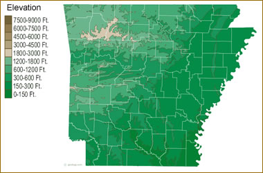 The topography of an area determines the direction of stream flow and often is a primary influence on the geographic distribution of precipitation. View a detailed Arkansas elevation map.


Find Other Topics on Geology.com:

|

| ||

|

| ||

|

| ||

|

|