Home » US Maps » Montana » Lakes and Rivers
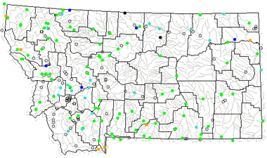
Montana Lakes, Rivers and Water Resources

ADVERTISEMENT
Montana Rivers Shown on the Map: Beaverhead River, Big Hole River, Big Horn River, Big Muddy Creek, Bitterroot River, Blackfoot Rriver, Clark Fork, Clarks Fork, Flathead River, Gallatin River, Jefferson River, Judith River, Kootenai River, Little Missouri River, Madison River, Marias River, Milk River, Missouri River, Musselshell River, O'Fallon Creek, Poplar River, Powder River, Red Rock River, Rosebud Creek, South Fork Flathead River, Sun River, Teton River, Tongue River and Yellowstone River.
Montana Lakes Shown on the Map: Canyon Ferry Lake, Flathead Lake, Fort Peck Lake, Fresno Reservoir, Hebgen Lake, Hungry Horse Reservoir, Lake Elwell, Lake Kooca, Medicine Lake and Nelson Reservoir.
| Montana Stream and River Levels |
 The United States Geological Survey has a number of stream gages located throughout Montana. These estimate stream levels, discharges and record them over time. This data is published on the web and many stations allow users to plot custom graphs. Get updated Montana river and stream levels from USGS here.
| Montana Stream and River Level Alerts |
 The United States Geological Survey has a system that will send you an email message when flood levels are reached on any steam with USGS gaging equipment that you have selected. Sign up here to recieve Montana stream and river level alerts.

| Montana Drought Map |
 The United States Geological Survey publishes updated drought maps on their website. There you can view a map that shows where below normal 7-day average stream flow conditions were recently recorded. The maps are updated daily. Get a current Montana drought map here.
| Montana Water Publications |
 The United States Geological Survey has a number of publications related to water use and water resources in Montana. Visit the Wyoming-Montana Water Science Center here.
| Montana Elevation Map |
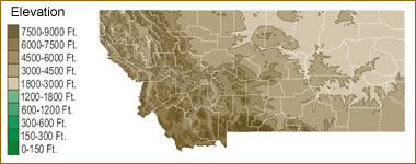 The topography of an area determines the direction of stream flow and often is a primary influence on the geographic distribution of precipitation. View a detailed Montana elevation map.


Find Other Topics on Geology.com:

|

| ||

|

| ||

|

| ||

|

|